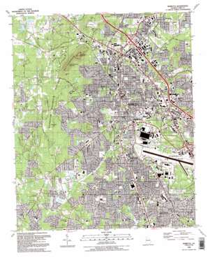
Marietta Topo Map Georgia
To zoom in, hover over the map of Marietta
USGS Topo Quad 33084h5 - 1:24,000 scale
| Topo Map Name: | Marietta |
| USGS Topo Quad ID: | 33084h5 |
| Print Size: | ca. 21 1/4" wide x 27" high |
| Southeast Coordinates: | 33.875° N latitude / 84.5° W longitude |
| Map Center Coordinates: | 33.9375° N latitude / 84.5625° W longitude |
| U.S. State: | GA |
| Filename: | o33084h5.jpg |
| Download Map JPG Image: | Marietta topo map 1:24,000 scale |
| Map Type: | Topographic |
| Topo Series: | 7.5´ |
| Map Scale: | 1:24,000 |
| Source of Map Images: | United States Geological Survey (USGS) |
| Alternate Map Versions: |
Marietta GA 1954, updated 1957 Download PDF Buy paper map Marietta GA 1954, updated 1966 Download PDF Buy paper map Marietta GA 1954, updated 1970 Download PDF Buy paper map Marietta GA 1954, updated 1974 Download PDF Buy paper map Marietta GA 1954, updated 1983 Download PDF Buy paper map Marietta GA 1954, updated 1987 Download PDF Buy paper map Marietta GA 1992, updated 1992 Download PDF Buy paper map Marietta GA 1992, updated 1992 Download PDF Buy paper map Marietta GA 2011 Download PDF Buy paper map Marietta GA 2014 Download PDF Buy paper map |
1:24,000 Topo Quads surrounding Marietta
> Back to 33084e1 at 1:100,000 scale
> Back to 33084a1 at 1:250,000 scale
> Back to U.S. Topo Maps home
Marietta topo map: Gazetteer
Marietta: Airports
Kennestone Heliport elevation 360m 1181′Matthews Heliport elevation 356m 1167′
Metro Heliport elevation 343m 1125′
Marietta: Crossings
Interchange 112 elevation 310m 1017′Interchange 113 elevation 310m 1017′
Interchange 114 elevation 340m 1115′
Interchange 115 elevation 312m 1023′
Marietta: Dams
Big Lake Dam elevation 286m 938′Brammett Lake Dam elevation 296m 971′
Canterbury Golf Club Dam elevation 327m 1072′
Cofer Lake Dam elevation 287m 941′
County Farm Lake Dam elevation 295m 967′
Daniell Lake Dam elevation 302m 990′
Haygoode Lake Dam elevation 313m 1026′
McNeels Dam elevation 294m 964′
Murrays Lake Dam elevation 306m 1003′
North Georgia Fairgrounds Lake Dam elevation 299m 980′
Reeves Lake Dam elevation 312m 1023′
Marietta: Parks
Al Bishop Park elevation 306m 1003′Al Burruss Nature Park elevation 292m 958′
American Adventure Amusement Park elevation 304m 997′
Bell Park elevation 323m 1059′
Birney Park elevation 321m 1053′
Bishop Park elevation 304m 997′
Brinkley Park elevation 325m 1066′
Centennial Park elevation 323m 1059′
Church Street Park elevation 295m 967′
Cobb Park elevation 298m 977′
Custer Park elevation 313m 1026′
Fair Oaks Park elevation 301m 987′
Glove Park elevation 344m 1128′
Gramling Street Park elevation 333m 1092′
Hedges Park elevation 335m 1099′
Hickory Hills Park elevation 332m 1089′
Kennesaw Mountain National Battlefield Park elevation 298m 977′
Kennesaw Village Park elevation 319m 1046′
Lake Drive Park elevation 321m 1053′
Larry Bell Recreational Center elevation 325m 1066′
Laurel Park elevation 318m 1043′
Lawrence Street Park elevation 348m 1141′
Lemon Street Stadium elevation 319m 1046′
Lewis Park elevation 346m 1135′
Memorial Park elevation 324m 1062′
Merritt Park elevation 299m 980′
Miller Park elevation 296m 971′
North Smyrna Park elevation 304m 997′
Odell Park elevation 305m 1000′
Page Park elevation 315m 1033′
Perry Parham Park elevation 317m 1040′
Rebel Ridge Park elevation 305m 1000′
Victory Park elevation 336m 1102′
Ward Park elevation 307m 1007′
Washington Avenue Historic District elevation 349m 1145′
White Water Theme Park elevation 309m 1013′
Whitlock Avenue Historic District elevation 317m 1040′
Wildwood Park elevation 326m 1069′
Wright Park elevation 339m 1112′
Marietta: Populated Places
Arbor Forest elevation 327m 1072′Blackwells elevation 339m 1112′
Clay Homes elevation 340m 1115′
Elizabeth elevation 354m 1161′
Fair Oaks elevation 336m 1102′
Fort Hill Homes elevation 328m 1076′
Kearns (historical) elevation 316m 1036′
Lamplighter Village Mobile Home Park elevation 305m 1000′
Marietta elevation 344m 1128′
Marietta Mobile Home Park elevation 300m 984′
Marietta Place Homes (historical) elevation 324m 1062′
Milford elevation 304m 997′
Oakton elevation 327m 1072′
Ridgewood Park elevation 295m 967′
Smyrna elevation 323m 1059′
Westoak elevation 346m 1135′
Whitlock elevation 317m 1040′
Marietta: Post Offices
Gresham Road Post Office elevation 335m 1099′Marietta: Reservoirs
Big Lake elevation 286m 938′Brammett Lake elevation 296m 971′
Canterbury Golf Club Lake elevation 327m 1072′
Cofer Lake elevation 287m 941′
County Farm Lake elevation 295m 967′
Daniell Lake elevation 302m 990′
Haygoode Lake elevation 313m 1026′
Holcomb Lake elevation 326m 1069′
McNeels Lake elevation 294m 964′
Murrays Lake elevation 306m 1003′
North Georgia Fairgrounds Lake elevation 299m 980′
Reeves Lake elevation 312m 1023′
Marietta: Summits
Cheatham Hill elevation 342m 1122′Kennesaw Mountain elevation 543m 1781′
Little Kennesaw Mountain elevation 488m 1601′
Pigeon Hill elevation 379m 1243′
Marietta digital topo map on disk
Buy this Marietta topo map showing relief, roads, GPS coordinates and other geographical features, as a high-resolution digital map file on DVD:


