La Grange Topo Map Georgia
To zoom in, hover over the map of La Grange
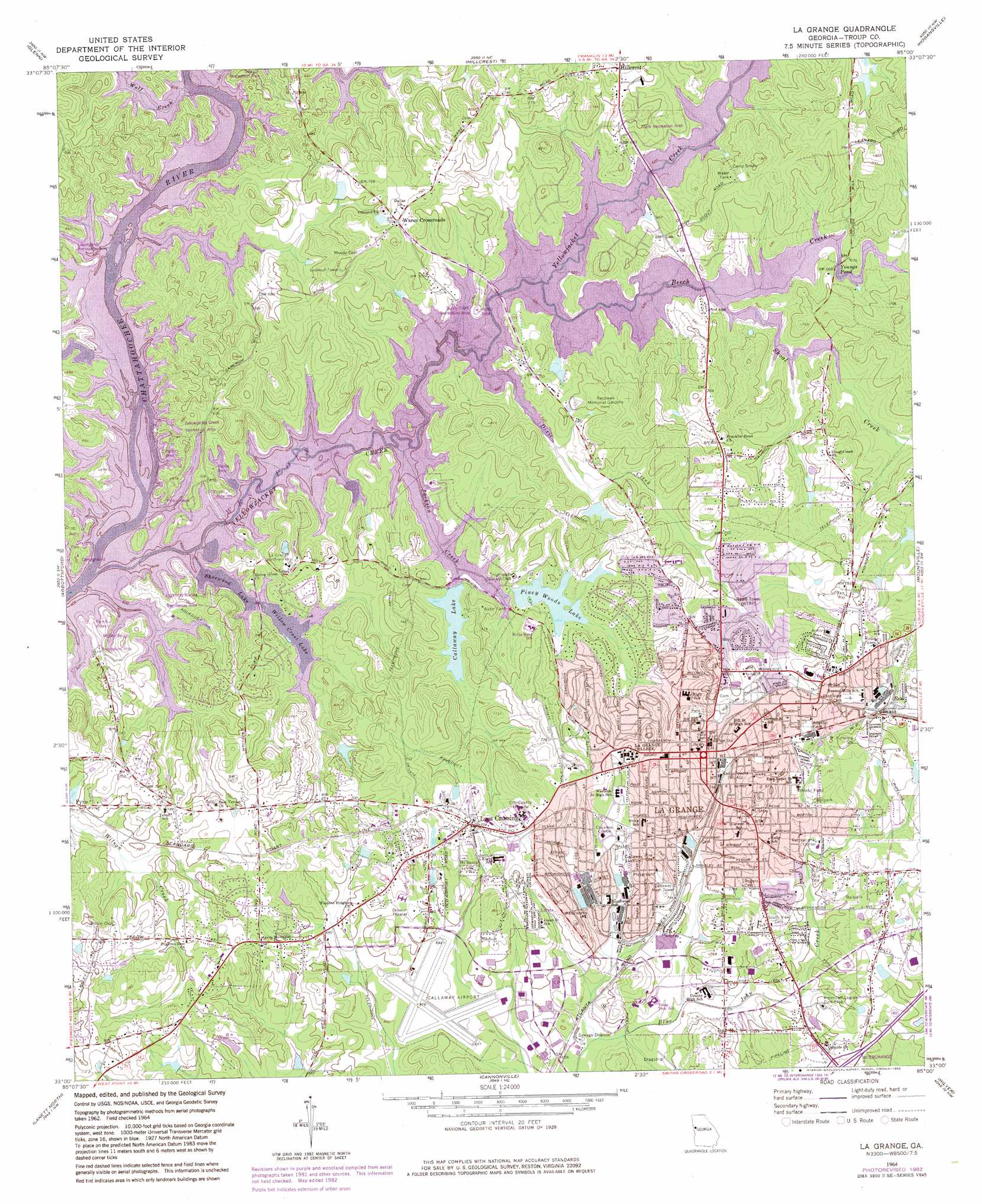
USGS Topo Quad 33085a1 - 1:24,000 scale
| Topo Map Name: | La Grange |
| USGS Topo Quad ID: | 33085a1 |
| Print Size: | ca. 21 1/4" wide x 27" high |
| Southeast Coordinates: | 33° N latitude / 85° W longitude |
| Map Center Coordinates: | 33.0625° N latitude / 85.0625° W longitude |
| U.S. State: | GA |
| Filename: | o33085a1.jpg |
| Download Map JPG Image: | La Grange topo map 1:24,000 scale |
| Map Type: | Topographic |
| Topo Series: | 7.5´ |
| Map Scale: | 1:24,000 |
| Source of Map Images: | United States Geological Survey (USGS) |
| Alternate Map Versions: |
La Grange GA 1964, updated 1975 Download PDF Buy paper map La Grange GA 1964, updated 1983 Download PDF Buy paper map La Grange GA 2011 Download PDF Buy paper map La Grange GA 2014 Download PDF Buy paper map |
1:24,000 Topo Quads surrounding La Grange
Napoleon |
Frolona |
Franklin |
Newnan Sw |
Newnan South |
Roanoke East |
Glenn |
Hillcrest |
Hogansville |
Grantville |
Five Points |
Abbottsford |
La Grange |
Mountville |
Odessadale |
Fredonia |
Lanett North |
Cannonville |
Hilyer |
Durand |
Cusseta |
Lanett South |
Whitesville |
Pine Mountain Sw |
Pine Mountain |
> Back to 33085a1 at 1:100,000 scale
> Back to 33084a1 at 1:250,000 scale
> Back to U.S. Topo Maps home
La Grange topo map: Gazetteer
La Grange: Airports
Callaway Airport elevation 207m 679′Richards Airport elevation 252m 826′
West Georgia Medical Center Heliport elevation 230m 754′
La Grange: Dams
Callaway Lake Dam elevation 195m 639′Hutchins Lake Dam elevation 205m 672′
Newnan Development Dam North elevation 210m 688′
Newnan Development Dam South elevation 202m 662′
La Grange: Islands
Swanson Island elevation 194m 636′La Grange: Lakes
Youngs Pond elevation 195m 639′La Grange: Parks
Broad Street Historic District elevation 234m 767′Callaway Park elevation 220m 721′
Callaway Stadium elevation 215m 705′
Clark Recreation Area elevation 208m 682′
Granger Park elevation 207m 679′
Highland Marina Recreation Area elevation 210m 688′
McGee Bridge Recreation Area elevation 201m 659′
Ogletree Park elevation 217m 711′
Pepperell Park elevation 235m 770′
Sunny Point Recreation Area elevation 201m 659′
Unity Park elevation 217m 711′
Yellowjacket Creek Recreation Area elevation 197m 646′
La Grange: Populated Places
Ashling Place elevation 212m 695′Beaver Cove elevation 213m 698′
Brookstone Estates elevation 236m 774′
Brookwood elevation 227m 744′
Cameron Cove elevation 207m 679′
Creek Ridge elevation 211m 692′
Eagles Rest elevation 214m 702′
Fernwood elevation 228m 748′
Foxcroft elevation 215m 705′
Greenwich Woods Estates elevation 224m 734′
Holly Hill elevation 201m 659′
La Grange elevation 240m 787′
Lake Forest Hills elevation 223m 731′
Lake West Point Estates elevation 211m 692′
Lees Crossing elevation 221m 725′
Meadowlands elevation 212m 695′
Moss Creek elevation 201m 659′
North Ridge elevation 203m 666′
Pinehaven Estates elevation 208m 682′
Piney Hills elevation 227m 744′
Riverview elevation 241m 790′
Riverwood elevation 229m 751′
Rockwell Estates elevation 235m 770′
Sassafrass Hills elevation 219m 718′
Spring Valley elevation 237m 777′
Stallings elevation 206m 675′
Sturbridge elevation 226m 741′
Sunny Point elevation 201m 659′
Teaver Hill elevation 221m 725′
The Crossings elevation 214m 702′
The Crossroads elevation 224m 734′
View Pointe elevation 205m 672′
Wares Crossroads elevation 231m 757′
Waterford Place elevation 206m 675′
West Wind elevation 225m 738′
West Wyngate elevation 235m 770′
Wildwood elevation 214m 702′
Willowcrest elevation 208m 682′
Woodfield elevation 221m 725′
Young Acres elevation 222m 728′
La Grange: Post Offices
La Grange Post Office elevation 246m 807′La Grange: Reservoirs
Callaway Lake elevation 195m 639′Hutchins Lake elevation 205m 672′
Newmans Pond elevation 207m 679′
Newnan Development Lake North elevation 210m 688′
Newnan Development Lake South elevation 202m 662′
Piney Hills Lake elevation 203m 666′
Piney Woods Lake elevation 200m 656′
Sherwood Lake elevation 194m 636′
Willow Crest Lake elevation 194m 636′
La Grange: Streams
Beech Creek elevation 194m 636′Dixie Creek elevation 194m 636′
Jackson Creek elevation 194m 636′
Shoal Creek elevation 194m 636′
Wolf Creek elevation 194m 636′
Yellowjacket Creek elevation 194m 636′
La Grange digital topo map on disk
Buy this La Grange topo map showing relief, roads, GPS coordinates and other geographical features, as a high-resolution digital map file on DVD: