Wadley North Topo Map Alabama
To zoom in, hover over the map of Wadley North
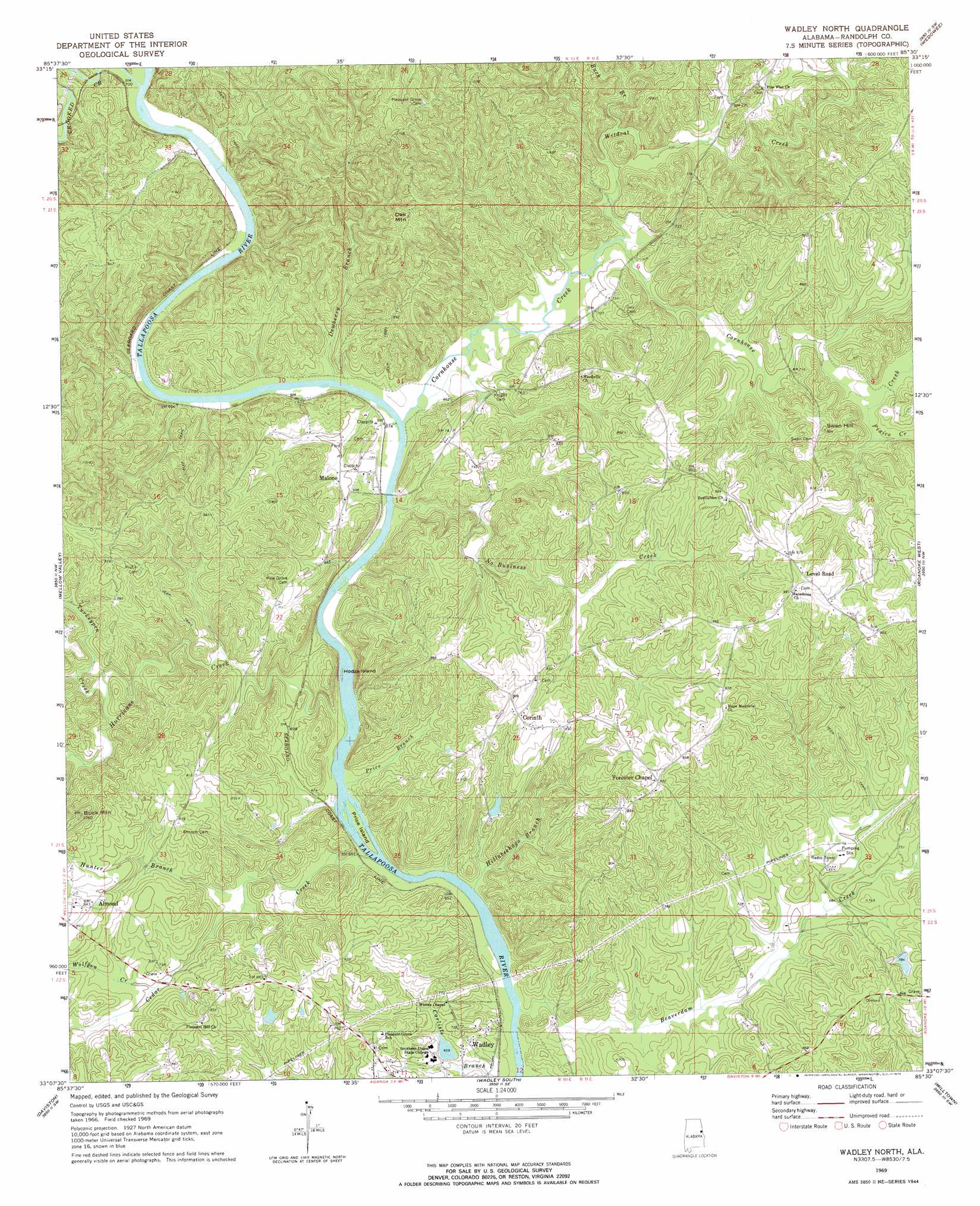
USGS Topo Quad 33085b5 - 1:24,000 scale
| Topo Map Name: | Wadley North |
| USGS Topo Quad ID: | 33085b5 |
| Print Size: | ca. 21 1/4" wide x 27" high |
| Southeast Coordinates: | 33.125° N latitude / 85.5° W longitude |
| Map Center Coordinates: | 33.1875° N latitude / 85.5625° W longitude |
| U.S. State: | AL |
| Filename: | o33085b5.jpg |
| Download Map JPG Image: | Wadley North topo map 1:24,000 scale |
| Map Type: | Topographic |
| Topo Series: | 7.5´ |
| Map Scale: | 1:24,000 |
| Source of Map Images: | United States Geological Survey (USGS) |
| Alternate Map Versions: |
Wadley North AL 1969, updated 1973 Download PDF Buy paper map Wadley North AL 1969, updated 1973 Download PDF Buy paper map Wadley North AL 2011 Download PDF Buy paper map Wadley North AL 2014 Download PDF Buy paper map |
1:24,000 Topo Quads surrounding Wadley North
Cheaha Mountain |
Delta |
Micaville |
Newell |
Graham |
Lineville West |
Lineville East |
Ofelia |
Wedowee |
Napoleon |
Gibsonville |
Mellow Valley |
Wadley North |
Roanoke West |
Roanoke East |
New Site |
Daviston |
Wadley South |
Milltown |
Five Points |
Jacksons Gap |
Buttston |
Dudleyville |
Lafayette |
Fredonia |
> Back to 33085a1 at 1:100,000 scale
> Back to 33084a1 at 1:250,000 scale
> Back to U.S. Topo Maps home
Wadley North topo map: Gazetteer
Wadley North: Crossings
Malone Ferry (historical) elevation 197m 646′Wellborne Ferry (historical) elevation 201m 659′
Wadley North: Dams
College Lake Dam elevation 199m 652′Frost Dam elevation 216m 708′
Knight Dam elevation 216m 708′
Transco Dam elevation 246m 807′
Wadley North: Islands
Hodge Island elevation 191m 626′Price Island elevation 190m 623′
Wadley North: Populated Places
Almond elevation 257m 843′Concord elevation 253m 830′
Corinth elevation 269m 882′
Forester Chapel elevation 288m 944′
Malone elevation 218m 715′
Wadley North: Reservoirs
College Lake elevation 199m 652′Frost Lake elevation 216m 708′
Wadley North: Streams
Beaverdam Creek elevation 186m 610′Buck Branch elevation 210m 688′
Cedar Creek elevation 188m 616′
Cornhouse Creek elevation 195m 639′
Crooked Creek elevation 201m 659′
Dewberry Branch elevation 197m 646′
Fixico Creek elevation 222m 728′
Hillabeehago Branch elevation 188m 616′
Hunter Branch elevation 198m 649′
Hurricane Creek elevation 192m 629′
No Business Creek elevation 194m 636′
Price Branch elevation 189m 620′
Turkeypen Creek elevation 222m 728′
Wildcat Creek elevation 207m 679′
Wolfpen Creek elevation 211m 692′
Wadley North: Summits
Buck Mountain elevation 321m 1053′Oak Mountain elevation 306m 1003′
Swan Hill elevation 276m 905′
Wadley North digital topo map on disk
Buy this Wadley North topo map showing relief, roads, GPS coordinates and other geographical features, as a high-resolution digital map file on DVD: