Cheaha Mountain Topo Map Alabama
To zoom in, hover over the map of Cheaha Mountain
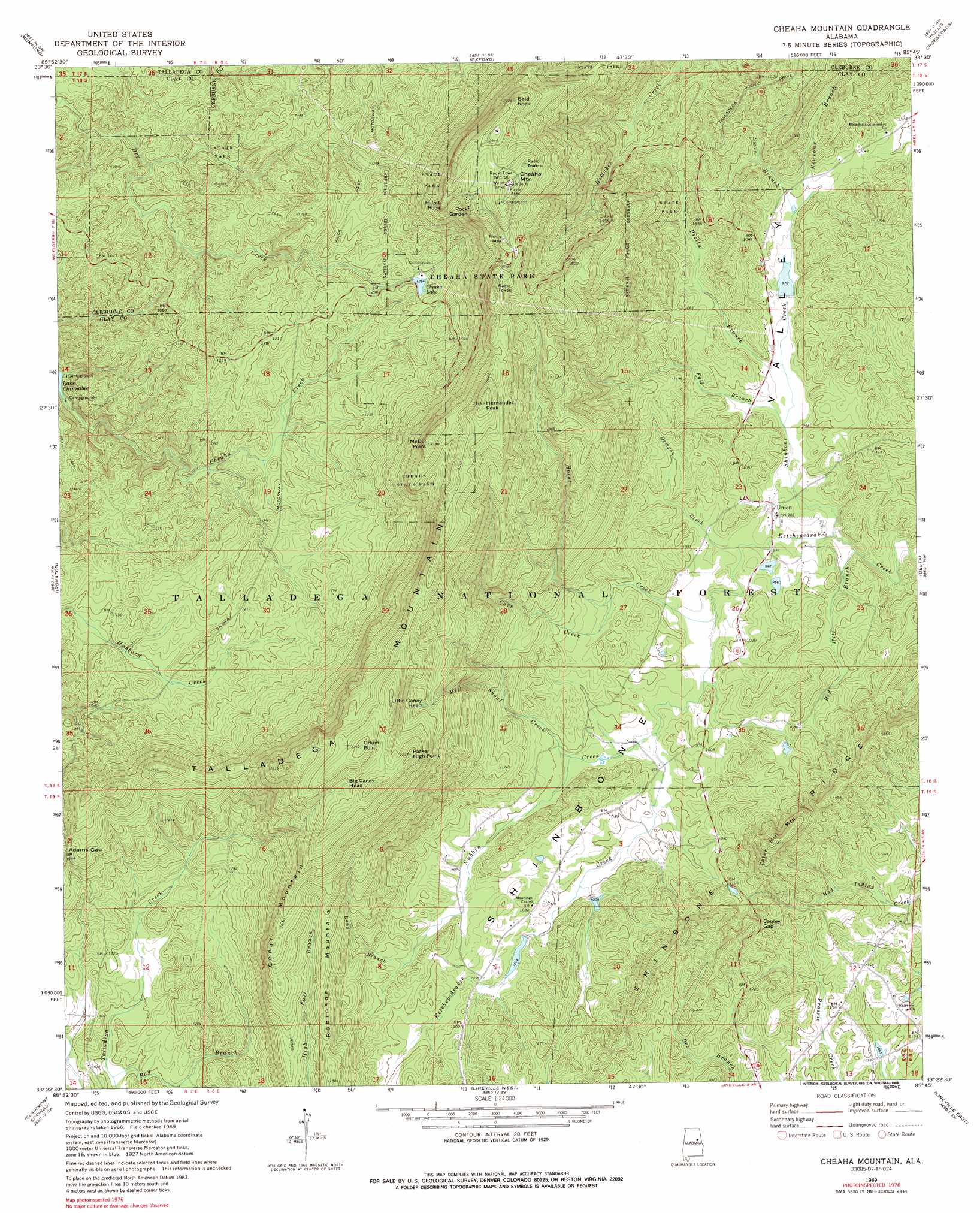
USGS Topo Quad 33085d7 - 1:24,000 scale
| Topo Map Name: | Cheaha Mountain |
| USGS Topo Quad ID: | 33085d7 |
| Print Size: | ca. 21 1/4" wide x 27" high |
| Southeast Coordinates: | 33.375° N latitude / 85.75° W longitude |
| Map Center Coordinates: | 33.4375° N latitude / 85.8125° W longitude |
| U.S. State: | AL |
| Filename: | o33085d7.jpg |
| Download Map JPG Image: | Cheaha Mountain topo map 1:24,000 scale |
| Map Type: | Topographic |
| Topo Series: | 7.5´ |
| Map Scale: | 1:24,000 |
| Source of Map Images: | United States Geological Survey (USGS) |
| Alternate Map Versions: |
Cheaha Mountain AL 1969, updated 1974 Download PDF Buy paper map Cheaha Mountain AL 1969, updated 1988 Download PDF Buy paper map Cheaha Mountain AL 1975, updated 1977 Download PDF Buy paper map Cheaha Mountain AL 2001, updated 2004 Download PDF Buy paper map Cheaha Mountain AL 2011 Download PDF Buy paper map Cheaha Mountain AL 2014 Download PDF Buy paper map |
| FStopo: | US Forest Service topo Cheaha Mountain is available: Download FStopo PDF Download FStopo TIF |
1:24,000 Topo Quads surrounding Cheaha Mountain
Francis Mill |
Eulaton |
Anniston |
Choccolocco |
Heflin |
Eastaboga |
Munford |
Oxford |
Hollis Crossroads |
Ross Mountain |
Talladega |
Ironaton |
Cheaha Mountain |
Delta |
Micaville |
Porter Gap |
Clairmont Springs |
Lineville West |
Lineville East |
Ofelia |
Bulls Gap |
Millerville |
Gibsonville |
Mellow Valley |
Wadley North |
> Back to 33085a1 at 1:100,000 scale
> Back to 33084a1 at 1:250,000 scale
> Back to U.S. Topo Maps home
Cheaha Mountain topo map: Gazetteer
Cheaha Mountain: Cliffs
Pulpit Rock elevation 599m 1965′Cheaha Mountain: Gaps
Adams Gap elevation 440m 1443′Cauley Gap elevation 377m 1236′
Cheaha Mountain: Islands
Rock Garden elevation 636m 2086′Cheaha Mountain: Mines
Brown Prospect elevation 329m 1079′Dempsey Mine elevation 299m 980′
Dempsey Prospect elevation 301m 987′
Dunlin Mine elevation 305m 1000′
Dye Prospect elevation 342m 1122′
Freeman Pit elevation 339m 1112′
Liberty Mine elevation 358m 1174′
M and G Mine elevation 358m 1174′
M and G Number Two Mine elevation 403m 1322′
McKay Prospect elevation 345m 1131′
McNamara Mine elevation 384m 1259′
Smith Mine elevation 317m 1040′
Yates Mine elevation 318m 1043′
Cheaha Mountain: Parks
Cheaha State Park elevation 645m 2116′Cheaha Mountain: Populated Places
Elder (historical) elevation 303m 994′Union elevation 294m 964′
Cheaha Mountain: Ranges
Talladega Mountain elevation 715m 2345′Cheaha Mountain: Reservoirs
Bonner Lake elevation 327m 1072′Burchfield Lake elevation 349m 1145′
Cheaha Lake elevation 390m 1279′
Headricks Lake elevation 343m 1125′
Lake Henry elevation 296m 971′
Cheaha Mountain: Ridges
Cedar Mountain elevation 556m 1824′Cheaha Mountain: Streams
Cave Creek elevation 310m 1017′Dempsy Creek elevation 283m 928′
Fall Branch elevation 288m 944′
Horse Creek elevation 286m 938′
Long Branch elevation 323m 1059′
Mill Shoal Creek elevation 298m 977′
Newsome Branch elevation 303m 994′
Nubbin Creek elevation 291m 954′
Pretty Branch elevation 290m 951′
Ray Branch elevation 296m 971′
Red Hill Branch elevation 280m 918′
Shinbone Creek elevation 280m 918′
Swan Branch elevation 301m 987′
Cheaha Mountain: Summits
Bald Rock elevation 696m 2283′Big Caney Head elevation 648m 2125′
Cheaha Mountain elevation 726m 2381′
Hernandez Peak elevation 703m 2306′
Little Caney Head elevation 572m 1876′
McDill Point elevation 648m 2125′
Odum Point elevation 714m 2342′
Parker High Point elevation 667m 2188′
Robinson Mountain elevation 479m 1571′
Tater Hill Mountain elevation 493m 1617′
Cheaha Mountain: Trails
Odum Trail elevation 677m 2221′Cheaha Mountain: Valleys
Shinbone Valley elevation 318m 1043′Cheaha Mountain digital topo map on disk
Buy this Cheaha Mountain topo map showing relief, roads, GPS coordinates and other geographical features, as a high-resolution digital map file on DVD: