Bowdon East Topo Map Georgia
To zoom in, hover over the map of Bowdon East
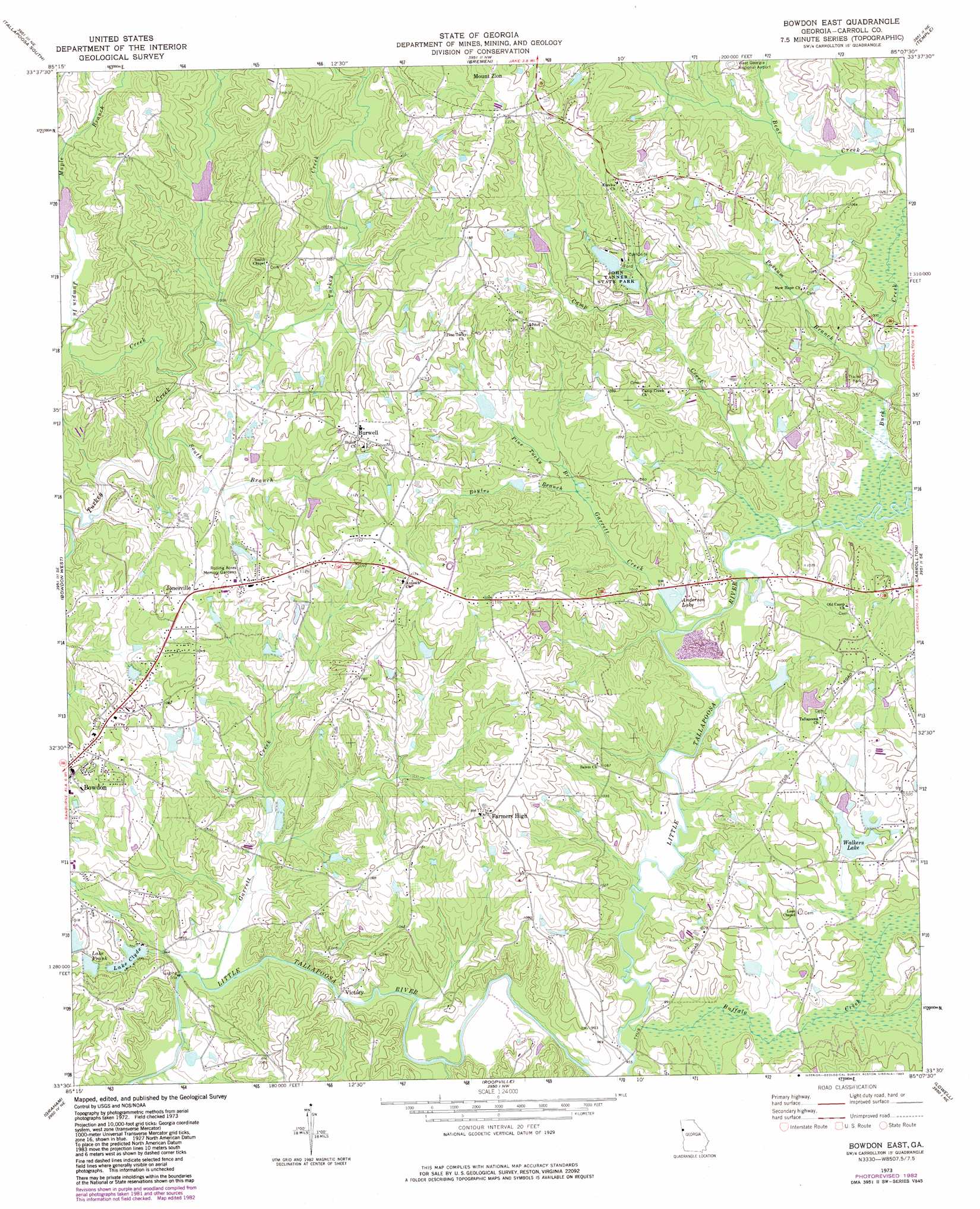
USGS Topo Quad 33085e2 - 1:24,000 scale
| Topo Map Name: | Bowdon East |
| USGS Topo Quad ID: | 33085e2 |
| Print Size: | ca. 21 1/4" wide x 27" high |
| Southeast Coordinates: | 33.5° N latitude / 85.125° W longitude |
| Map Center Coordinates: | 33.5625° N latitude / 85.1875° W longitude |
| U.S. State: | GA |
| Filename: | o33085e2.jpg |
| Download Map JPG Image: | Bowdon East topo map 1:24,000 scale |
| Map Type: | Topographic |
| Topo Series: | 7.5´ |
| Map Scale: | 1:24,000 |
| Source of Map Images: | United States Geological Survey (USGS) |
| Alternate Map Versions: |
Bowdon East GA 1973, updated 1975 Download PDF Buy paper map Bowdon East GA 1973, updated 1983 Download PDF Buy paper map Bowdon East GA 2011 Download PDF Buy paper map Bowdon East GA 2014 Download PDF Buy paper map |
1:24,000 Topo Quads surrounding Bowdon East
Oak Level |
Tallapoosa North |
Buchanan |
Draketown |
New Georgia |
Fruithurst |
Tallapoosa South |
Bremen |
Temple |
Villa Rica |
Hightower |
Bowdon West |
Bowdon East |
Carrollton |
Hulett |
Newell |
Graham |
Roopville |
Lowell |
Whitesburg |
Wedowee |
Napoleon |
Frolona |
Franklin |
Newnan Sw |
> Back to 33085e1 at 1:100,000 scale
> Back to 33084a1 at 1:250,000 scale
> Back to U.S. Topo Maps home
Bowdon East topo map: Gazetteer
Bowdon East: Bridges
Brock Bridge (historical) elevation 280m 918′New Bridge elevation 293m 961′
Bowdon East: Dams
Cole Lake Dam elevation 304m 997′Inman Dam elevation 322m 1056′
John Tanner State Park Lake Dam A elevation 329m 1079′
John Tanner State Park Lake Dam B elevation 325m 1066′
Lake Clyde Dam elevation 296m 971′
Lake Frank Dam elevation 302m 990′
Nessinger Lake Dam elevation 314m 1030′
Shadinger Lake Dam elevation 317m 1040′
Swins Lake Dam A elevation 309m 1013′
Swins Lake Dam B elevation 320m 1049′
W Walkers Dam elevation 308m 1010′
Walkers Dam elevation 300m 984′
Wessinger Dam elevation 311m 1020′
Bowdon East: Lakes
Lake Woodfin elevation 302m 990′Bowdon East: Parks
John Tanner State Park elevation 334m 1095′Bowdon East: Populated Places
Burwell elevation 336m 1102′Double Branches elevation 299m 980′
Fairview (historical) elevation 335m 1099′
Farmers High elevation 341m 1118′
Jonesville elevation 329m 1079′
Luckie (historical) elevation 358m 1174′
Plowshare (historical) elevation 327m 1072′
Victory elevation 287m 941′
Bowdon East: Reservoirs
Anderson Lake elevation 296m 971′Carroll Lake elevation 330m 1082′
Cole Lake elevation 304m 997′
Inman Lake elevation 322m 1056′
John Tanner State Park Lake A elevation 329m 1079′
John Tanner State Park Lake B elevation 325m 1066′
Lake Clyde elevation 293m 961′
Lake Frank elevation 305m 1000′
Moon Lake elevation 317m 1040′
Shadinger Lake elevation 317m 1040′
Swins Lake A elevation 309m 1013′
Swins Lake B elevation 320m 1049′
Tanners Lake elevation 320m 1049′
W Walkers Lake elevation 308m 1010′
Walkers Lake elevation 300m 984′
Wessinger Lake elevation 314m 1030′
Wessinger Lake elevation 311m 1020′
Bowdon East: Streams
Boyles Branch elevation 305m 1000′Buck Creek elevation 297m 974′
Buffalo Creek elevation 293m 961′
Camp Creek elevation 299m 980′
Garrett Creek elevation 286m 938′
Garrett Creek elevation 293m 961′
Jumpin In Creek elevation 305m 1000′
Maple Branch elevation 317m 1040′
Pine Tucky Branch elevation 305m 1000′
Possum Branch elevation 299m 980′
South Branch Turkey Creek elevation 305m 1000′
Words Creek elevation 287m 941′
Bowdon East digital topo map on disk
Buy this Bowdon East topo map showing relief, roads, GPS coordinates and other geographical features, as a high-resolution digital map file on DVD: