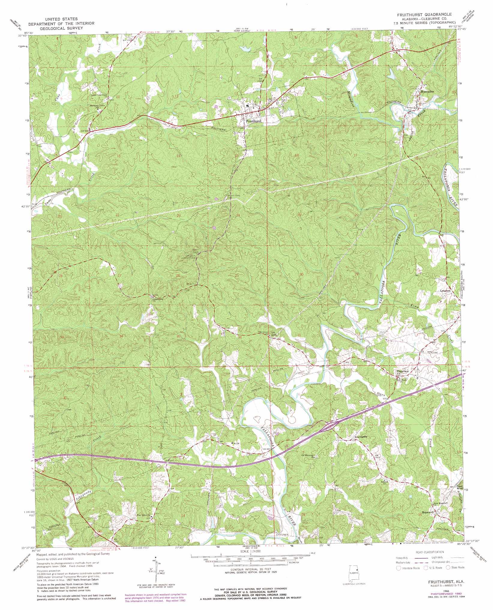
Fruithurst Topo Map Alabama
To zoom in, hover over the map of Fruithurst
USGS Topo Quad 33085f4 - 1:24,000 scale
| Topo Map Name: | Fruithurst |
| USGS Topo Quad ID: | 33085f4 |
| Print Size: | ca. 21 1/4" wide x 27" high |
| Southeast Coordinates: | 33.625° N latitude / 85.375° W longitude |
| Map Center Coordinates: | 33.6875° N latitude / 85.4375° W longitude |
| U.S. State: | AL |
| Filename: | o33085f4.jpg |
| Download Map JPG Image: | Fruithurst topo map 1:24,000 scale |
| Map Type: | Topographic |
| Topo Series: | 7.5´ |
| Map Scale: | 1:24,000 |
| Source of Map Images: | United States Geological Survey (USGS) |
| Alternate Map Versions: |
Fruithurst AL 1966, updated 1968 Download PDF Buy paper map Fruithurst AL 1966, updated 1980 Download PDF Buy paper map Fruithurst AL 1975, updated 1977 Download PDF Buy paper map Fruithurst AL 2011 Download PDF Buy paper map Fruithurst AL 2014 Download PDF Buy paper map |
1:24,000 Topo Quads surrounding Fruithurst
Piedmont Nw |
Piedmont |
Borden Springs |
Benedict |
Felton |
Jacksonville East |
Piedmont Se |
Oak Level |
Tallapoosa North |
Buchanan |
Choccolocco |
Heflin |
Fruithurst |
Tallapoosa South |
Bremen |
Hollis Crossroads |
Ross Mountain |
Hightower |
Bowdon West |
Bowdon East |
Delta |
Micaville |
Newell |
Graham |
Roopville |
> Back to 33085e1 at 1:100,000 scale
> Back to 33084a1 at 1:250,000 scale
> Back to U.S. Topo Maps home
Fruithurst topo map: Gazetteer
Fruithurst: Crossings
Interchange 210 elevation 299m 980′Smith Ford elevation 276m 905′
Fruithurst: Dams
Laminack Dam elevation 302m 990′Nelson Dam elevation 311m 1020′
Fruithurst: Gaps
Mains Gap elevation 308m 1010′Fruithurst: Populated Places
Abernathy elevation 313m 1026′Ai elevation 298m 977′
Fruithurst elevation 329m 1079′
Hopewell elevation 323m 1059′
Muscadine elevation 311m 1020′
Plainview elevation 306m 1003′
Fruithurst: Post Offices
Fair Play Post Office (historical) elevation 302m 990′Kemps Post Office (historical) elevation 274m 898′
Fruithurst: Reservoirs
Laminack Lake elevation 302m 990′Nelsons Lake elevation 311m 1020′
Fruithurst: Streams
Albright Creek elevation 299m 980′Bennett Creek elevation 299m 980′
Kemp Creek elevation 274m 898′
Macola Creek elevation 263m 862′
Owen Creek elevation 268m 879′
Fruithurst digital topo map on disk
Buy this Fruithurst topo map showing relief, roads, GPS coordinates and other geographical features, as a high-resolution digital map file on DVD: