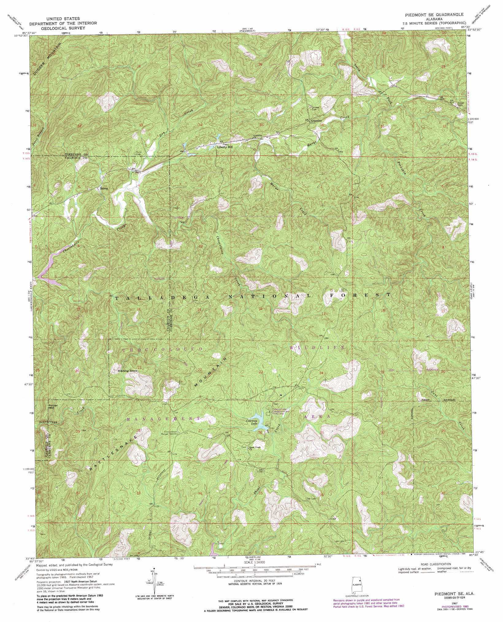
Piedmont Se Topo Map Alabama
To zoom in, hover over the map of Piedmont Se
USGS Topo Quad 33085g5 - 1:24,000 scale
| Topo Map Name: | Piedmont Se |
| USGS Topo Quad ID: | 33085g5 |
| Print Size: | ca. 21 1/4" wide x 27" high |
| Southeast Coordinates: | 33.75° N latitude / 85.5° W longitude |
| Map Center Coordinates: | 33.8125° N latitude / 85.5625° W longitude |
| U.S. State: | AL |
| Filename: | o33085g5.jpg |
| Download Map JPG Image: | Piedmont Se topo map 1:24,000 scale |
| Map Type: | Topographic |
| Topo Series: | 7.5´ |
| Map Scale: | 1:24,000 |
| Source of Map Images: | United States Geological Survey (USGS) |
| Alternate Map Versions: |
Piedmont SE AL 1967, updated 1970 Download PDF Buy paper map Piedmont SE AL 1967, updated 1985 Download PDF Buy paper map Piedmont SE AL 1975, updated 1977 Download PDF Buy paper map Piedmont SE AL 2001, updated 2004 Download PDF Buy paper map Piedmont SE AL 2011 Download PDF Buy paper map Piedmont SE AL 2014 Download PDF Buy paper map |
| FStopo: | US Forest Service topo Piedmont SE is available: Download FStopo PDF Download FStopo TIF |
1:24,000 Topo Quads surrounding Piedmont Se
Ballplay |
Weisner Mountain |
Ellisville |
Indian Mountain |
Cedartown West |
Colvin Gap |
Piedmont Nw |
Piedmont |
Borden Springs |
Benedict |
Jacksonville West |
Jacksonville East |
Piedmont Se |
Oak Level |
Tallapoosa North |
Anniston |
Choccolocco |
Heflin |
Fruithurst |
Tallapoosa South |
Oxford |
Hollis Crossroads |
Ross Mountain |
Hightower |
Bowdon West |
> Back to 33085e1 at 1:100,000 scale
> Back to 33084a1 at 1:250,000 scale
> Back to U.S. Topo Maps home
Piedmont Se topo map: Gazetteer
Piedmont Se: Dams
Choccolocco Number 2 Dam elevation 231m 757′Coleman Dam elevation 363m 1190′
Coleman Dam elevation 387m 1269′
Piedmont Se: Parks
Choccolocco Wildlife Management Area elevation 403m 1322′Coleman Lake Campground and Picnic Area elevation 359m 1177′
Shoal Creek Picnic Area elevation 335m 1099′
Piedmont Se: Populated Places
Abernathy (historical) elevation 372m 1220′Burns elevation 259m 849′
Grantley elevation 298m 977′
Liberty Hill elevation 288m 944′
Piedmont Se: Reservoirs
Coleman Lake elevation 387m 1269′Coleman Lake elevation 347m 1138′
Piedmont Se: Streams
Dry Creek elevation 249m 816′Marys Creek elevation 236m 774′
Piedmont Se: Summits
Hitching Beech elevation 380m 1246′Potter Mountain elevation 389m 1276′
Rattlesnake Mountain elevation 460m 1509′
Wilkinson Mountain elevation 505m 1656′
Piedmont Se digital topo map on disk
Buy this Piedmont Se topo map showing relief, roads, GPS coordinates and other geographical features, as a high-resolution digital map file on DVD: