Benedict Topo Map Georgia
To zoom in, hover over the map of Benedict
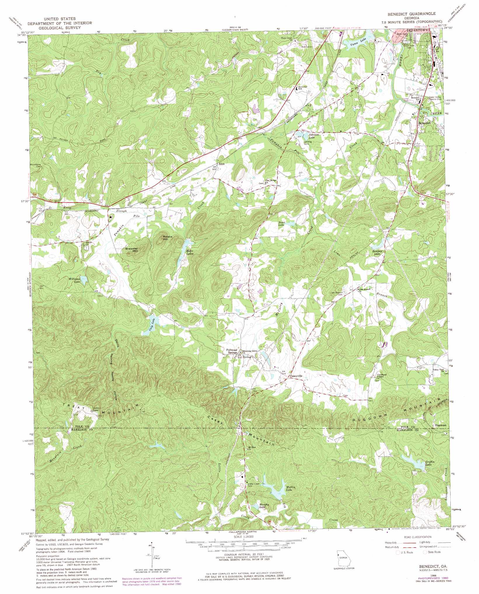
USGS Topo Quad 33085h3 - 1:24,000 scale
| Topo Map Name: | Benedict |
| USGS Topo Quad ID: | 33085h3 |
| Print Size: | ca. 21 1/4" wide x 27" high |
| Southeast Coordinates: | 33.875° N latitude / 85.25° W longitude |
| Map Center Coordinates: | 33.9375° N latitude / 85.3125° W longitude |
| U.S. State: | GA |
| Filename: | o33085h3.jpg |
| Download Map JPG Image: | Benedict topo map 1:24,000 scale |
| Map Type: | Topographic |
| Topo Series: | 7.5´ |
| Map Scale: | 1:24,000 |
| Source of Map Images: | United States Geological Survey (USGS) |
| Alternate Map Versions: |
Benedict GA 1966, updated 1967 Download PDF Buy paper map Benedict GA 1966, updated 1980 Download PDF Buy paper map Benedict GA 2011 Download PDF Buy paper map Benedict GA 2014 Download PDF Buy paper map |
1:24,000 Topo Quads surrounding Benedict
Cedar Bluff |
Melson |
Livingston |
Rome South |
Wax |
Ellisville |
Indian Mountain |
Cedartown West |
Cedartown East |
Rockmart North |
Piedmont |
Borden Springs |
Benedict |
Felton |
Rockmart South |
Piedmont Se |
Oak Level |
Tallapoosa North |
Buchanan |
Draketown |
Heflin |
Fruithurst |
Tallapoosa South |
Bremen |
Temple |
> Back to 33085e1 at 1:100,000 scale
> Back to 33084a1 at 1:250,000 scale
> Back to U.S. Topo Maps home
Benedict topo map: Gazetteer
Benedict: Dams
Big Cedar Creek Structure Number 13 Dam elevation 268m 879′Culp Lake Dam elevation 276m 905′
Griffin Lake Dam elevation 332m 1089′
Lower Elder Lake Dam elevation 256m 839′
Mullin Lake Dam elevation 323m 1059′
Upper Elder Lake Dam elevation 271m 889′
Vance Lake Dam elevation 241m 790′
Williams Lake Dam elevation 273m 895′
Benedict: Mines
Woodward Mine elevation 266m 872′Benedict: Populated Places
Akes elevation 253m 830′Benedict elevation 248m 813′
Caseyville elevation 277m 908′
Dugdown elevation 343m 1125′
Fullwood Springs elevation 274m 898′
Greenway (historical) elevation 271m 889′
Little Creek elevation 354m 1161′
Treat (historical) elevation 388m 1272′
Walthrall (historical) elevation 262m 859′
Benedict: Reservoirs
Benedicts Pond elevation 238m 780′Bentley Lake elevation 264m 866′
Culp Lake elevation 276m 905′
Elder Lakes elevation 263m 862′
Griffin Lake elevation 332m 1089′
Johnson Lake elevation 251m 823′
Lower Elder Lake elevation 256m 839′
Mullin Lake elevation 348m 1141′
Murphy Lake elevation 333m 1092′
Pettit Lake elevation 251m 823′
Shiloh Lake elevation 268m 879′
Upper Elder Lake elevation 271m 889′
Vance Lake elevation 241m 790′
Williams Lake elevation 273m 895′
Benedict: Springs
West Spring elevation 250m 820′Benedict: Streams
Esom Slough elevation 256m 839′Esom Slough elevation 256m 839′
Lime Branch elevation 244m 800′
Little Creek elevation 323m 1059′
McCurry Creek elevation 241m 790′
Pumpkin Pile Creek elevation 235m 770′
Benedict: Summits
Brewster Mountain elevation 343m 1125′Casey Mountain elevation 379m 1243′
Dugdown Mountain elevation 356m 1167′
Loveless Mountain elevation 377m 1236′
Potato Hill elevation 320m 1049′
Treat Mountain elevation 420m 1377′
Benedict: Valleys
Devils Darning Needle Hollow elevation 293m 961′Benedict digital topo map on disk
Buy this Benedict topo map showing relief, roads, GPS coordinates and other geographical features, as a high-resolution digital map file on DVD: