Goodwater Topo Map Alabama
To zoom in, hover over the map of Goodwater
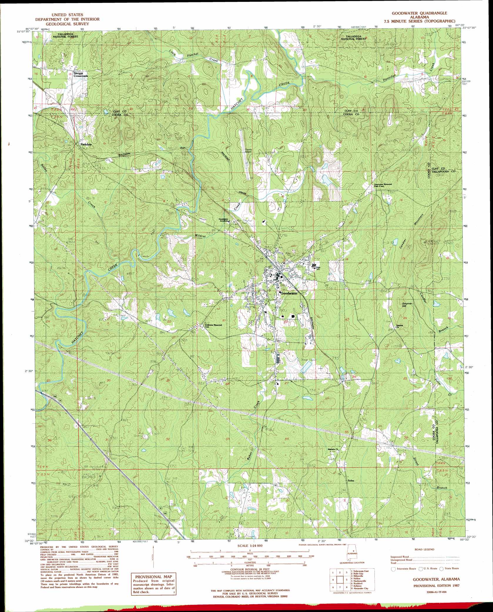
USGS Topo Quad 33086a1 - 1:24,000 scale
| Topo Map Name: | Goodwater |
| USGS Topo Quad ID: | 33086a1 |
| Print Size: | ca. 21 1/4" wide x 27" high |
| Southeast Coordinates: | 33° N latitude / 86° W longitude |
| Map Center Coordinates: | 33.0625° N latitude / 86.0625° W longitude |
| U.S. State: | AL |
| Filename: | o33086a1.jpg |
| Download Map JPG Image: | Goodwater topo map 1:24,000 scale |
| Map Type: | Topographic |
| Topo Series: | 7.5´ |
| Map Scale: | 1:24,000 |
| Source of Map Images: | United States Geological Survey (USGS) |
| Alternate Map Versions: |
Goodwater SW AL 1975, updated 1977 Download PDF Buy paper map Goodwater AL 1987, updated 1987 Download PDF Buy paper map Goodwater AL 2001, updated 2004 Download PDF Buy paper map Goodwater AL 2011 Download PDF Buy paper map Goodwater AL 2014 Download PDF Buy paper map |
| FStopo: | US Forest Service topo Goodwater is available: Download FStopo PDF Download FStopo TIF |
1:24,000 Topo Quads surrounding Goodwater
Childersburg |
Winterboro |
Porter Gap |
Clairmont Springs |
Lineville West |
Sylacauga West |
Sylacauga East |
Bulls Gap |
Millerville |
Gibsonville |
Weogufka |
Hollins |
Goodwater |
Hackneyville |
New Site |
Flag Mountain |
Rockford |
Kellyton |
Alexander City |
Jacksons Gap |
Richville |
Rockford Sw |
Equality |
Our Town |
Dadeville |
> Back to 33086a1 at 1:100,000 scale
> Back to 33086a1 at 1:250,000 scale
> Back to U.S. Topo Maps home
Goodwater topo map: Gazetteer
Goodwater: Airports
Coosa County Airport elevation 284m 931′Goodwater: Crossings
Ross Ford elevation 216m 708′Goodwater: Dams
Bailey Dam elevation 235m 770′Baker Creek Lagoon Dam elevation 221m 725′
Griffin Harris Lake Dam elevation 264m 866′
Peoples Lake Dam elevation 245m 803′
Peoples Lake Number 2 Dam elevation 248m 813′
Goodwater: Populated Places
Goodwater elevation 256m 839′Hatchet elevation 273m 895′
Parkdale elevation 259m 849′
Skeggs Crossroads elevation 256m 839′
Soleo elevation 231m 757′
Goodwater: Reservoirs
Bailey Lake elevation 235m 770′Baker Creek Lagoon elevation 221m 725′
Griffin Harris Lake elevation 264m 866′
Peoples Lake Number 2 elevation 248m 813′
Goodwater: Streams
Camp Branch elevation 222m 728′Little Hatchet Creek elevation 217m 711′
Partridge Creek elevation 220m 721′
Wildcat Creek elevation 209m 685′
Goodwater: Summits
Candler Mountain elevation 350m 1148′Smyrna Hill elevation 240m 787′
Goodwater digital topo map on disk
Buy this Goodwater topo map showing relief, roads, GPS coordinates and other geographical features, as a high-resolution digital map file on DVD: