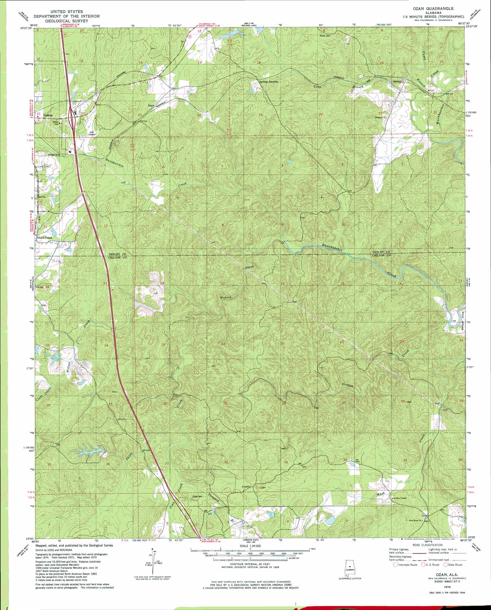
Ozan Topo Map Alabama
To zoom in, hover over the map of Ozan
USGS Topo Quad 33086a6 - 1:24,000 scale
| Topo Map Name: | Ozan |
| USGS Topo Quad ID: | 33086a6 |
| Print Size: | ca. 21 1/4" wide x 27" high |
| Southeast Coordinates: | 33° N latitude / 86.625° W longitude |
| Map Center Coordinates: | 33.0625° N latitude / 86.6875° W longitude |
| U.S. State: | AL |
| Filename: | o33086a6.jpg |
| Download Map JPG Image: | Ozan topo map 1:24,000 scale |
| Map Type: | Topographic |
| Topo Series: | 7.5´ |
| Map Scale: | 1:24,000 |
| Source of Map Images: | United States Geological Survey (USGS) |
| Alternate Map Versions: |
Columbiana SW AL 1975, updated 1977 Download PDF Buy paper map Ozan AL 1979, updated 1980 Download PDF Buy paper map Ozan AL 2011 Download PDF Buy paper map Ozan AL 2014 Download PDF Buy paper map |
1:24,000 Topo Quads surrounding Ozan
Greenwood |
Helena |
Chelsea |
Westover |
Harpersville |
Pea Ridge |
Alabaster |
Bounds Lake |
Columbiana |
Wilsonville |
Aldrich |
Montevallo |
Ozan |
Shelby |
Talladega Springs |
Randolph |
Jemison West |
Jemison East |
Lay Dam |
Mitchell Dam Nw |
Maplesville West |
Maplesville East |
Clanton West |
Clanton East |
Mitchell Dam |
> Back to 33086a1 at 1:100,000 scale
> Back to 33086a1 at 1:250,000 scale
> Back to U.S. Topo Maps home
Ozan topo map: Gazetteer
Ozan: Crossings
Interchange 228 elevation 165m 541′Ozan: Dams
Gilbert Lake Dam elevation 174m 570′Gulf States Columbiana SW Dam elevation 184m 603′
Mitchell Lake Dam elevation 166m 544′
Ozan: Populated Places
Ozan elevation 164m 538′South Calera elevation 163m 534′
Springs Junction elevation 169m 554′
Ozan: Reservoirs
Gilberts Lake elevation 174m 570′Gulf States Columbiana SW Lake elevation 184m 603′
Mitchell Lake elevation 166m 544′
Ozan: Streams
Camp Branch elevation 127m 416′Clear Creek elevation 157m 515′
Cobb Creek elevation 156m 511′
Long Branch elevation 128m 419′
Stumps Creek elevation 121m 396′
Tanyard Branch elevation 161m 528′
Third Creek elevation 141m 462′
Watson Creek elevation 131m 429′
Ozan digital topo map on disk
Buy this Ozan topo map showing relief, roads, GPS coordinates and other geographical features, as a high-resolution digital map file on DVD: