Alabaster Topo Map Alabama
To zoom in, hover over the map of Alabaster
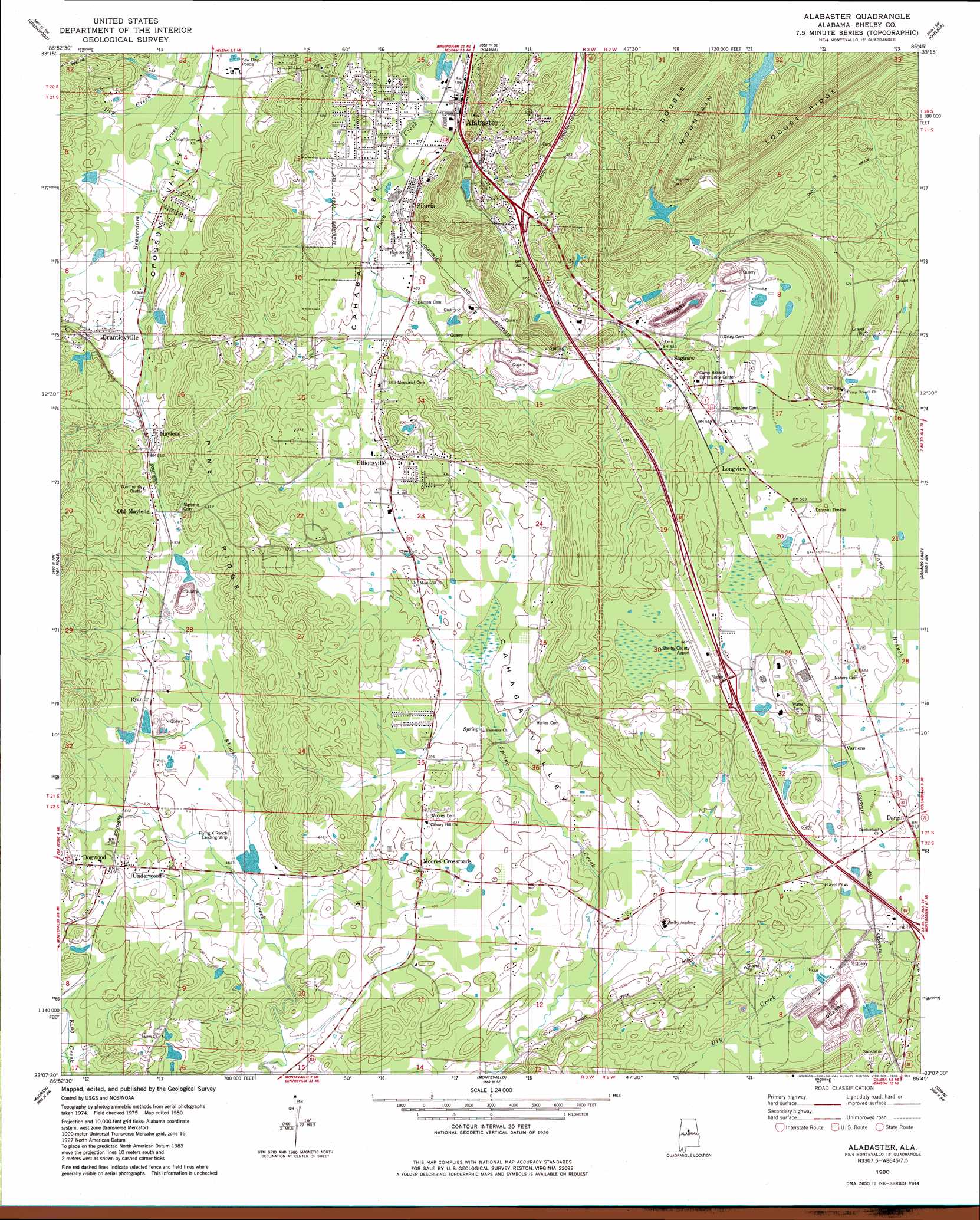
USGS Topo Quad 33086b7 - 1:24,000 scale
| Topo Map Name: | Alabaster |
| USGS Topo Quad ID: | 33086b7 |
| Print Size: | ca. 21 1/4" wide x 27" high |
| Southeast Coordinates: | 33.125° N latitude / 86.75° W longitude |
| Map Center Coordinates: | 33.1875° N latitude / 86.8125° W longitude |
| U.S. State: | AL |
| Filename: | o33086b7.jpg |
| Download Map JPG Image: | Alabaster topo map 1:24,000 scale |
| Map Type: | Topographic |
| Topo Series: | 7.5´ |
| Map Scale: | 1:24,000 |
| Source of Map Images: | United States Geological Survey (USGS) |
| Alternate Map Versions: |
Montevallo NE AL 1975, updated 1977 Download PDF Buy paper map Alabaster AL 1980, updated 1980 Download PDF Buy paper map Alabaster AL 1980, updated 1984 Download PDF Buy paper map Alabaster AL 1980, updated 1984 Download PDF Buy paper map Alabaster AL 2011 Download PDF Buy paper map Alabaster AL 2014 Download PDF Buy paper map |
1:24,000 Topo Quads surrounding Alabaster
Concord |
Bessemer |
Birmingham South |
Cahaba Heights |
Vandiver |
Mccalla |
Greenwood |
Helena |
Chelsea |
Westover |
Halfmile Shoals |
Pea Ridge |
Alabaster |
Bounds Lake |
Columbiana |
West Blocton East |
Aldrich |
Montevallo |
Ozan |
Shelby |
Centreville East |
Randolph |
Jemison West |
Jemison East |
Lay Dam |
> Back to 33086a1 at 1:100,000 scale
> Back to 33086a1 at 1:250,000 scale
> Back to U.S. Topo Maps home
Alabaster topo map: Gazetteer
Alabaster: Airports
Flying X Ranch Airport elevation 143m 469′Shelby County Airport elevation 171m 561′
Alabaster: Crossings
Interchange 234 elevation 182m 597′Interchange 238 elevation 168m 551′
Alabaster: Dams
Fulton Lake Dam elevation 198m 649′Kimberly-Clark Dam elevation 207m 679′
Salter Dam elevation 140m 459′
Alabaster: Mines
Calera Quarry elevation 166m 544′Alabaster: Populated Places
Alabaster elevation 153m 501′Brantleyville elevation 169m 554′
Camp Branch elevation 181m 593′
Country Hills elevation 162m 531′
Dargin elevation 171m 561′
Dogwood elevation 164m 538′
Eaglewood Estates elevation 146m 479′
Elliotsville elevation 158m 518′
Glen Forest elevation 153m 501′
Ivanhoe elevation 170m 557′
Longview elevation 177m 580′
Maylene elevation 150m 492′
Meadow Green elevation 153m 501′
Mission Hills elevation 173m 567′
Montalla Acres elevation 182m 597′
Monte Bello elevation 163m 534′
Moores Crossroads elevation 149m 488′
Old Maylene elevation 163m 534′
Pasqua elevation 175m 574′
Ryan elevation 161m 528′
Saginaw elevation 166m 544′
Scottsdale elevation 171m 561′
Siluria elevation 150m 492′
Stems elevation 176m 577′
Underwood elevation 159m 521′
Varnons elevation 171m 561′
Verlie elevation 159m 521′
Willmay elevation 177m 580′
Willow Glen elevation 161m 528′
Woodland Hills elevation 143m 469′
Alabaster: Post Offices
Flora Post Office (historical) elevation 163m 534′Lees Cove Post Office (historical) elevation 154m 505′
Maylene Post Office elevation 150m 492′
Woodsboro Post Office (historical) elevation 164m 538′
Alabaster: Reservoirs
Fultons Lake elevation 198m 649′Kimberly-Clark Lake elevation 207m 679′
Salter Lake elevation 140m 459′
Alabaster: Ridges
Pine Ridge elevation 206m 675′Alabaster: Springs
Blue Spring elevation 143m 469′Buck Creek Spring elevation 146m 479′
Griffin Spring elevation 145m 475′
Stancel Spring elevation 146m 479′
Alabaster: Valleys
Cahaba Valley elevation 140m 459′Opossum Valley elevation 148m 485′
Alabaster digital topo map on disk
Buy this Alabaster topo map showing relief, roads, GPS coordinates and other geographical features, as a high-resolution digital map file on DVD: