Winterboro Topo Map Alabama
To zoom in, hover over the map of Winterboro
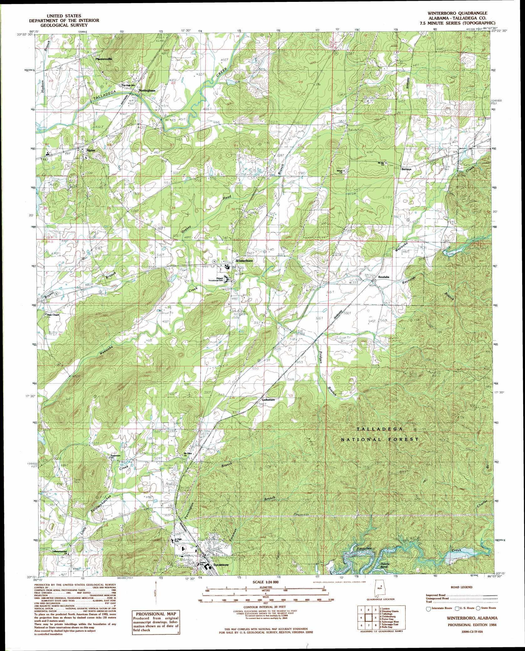
USGS Topo Quad 33086c2 - 1:24,000 scale
| Topo Map Name: | Winterboro |
| USGS Topo Quad ID: | 33086c2 |
| Print Size: | ca. 21 1/4" wide x 27" high |
| Southeast Coordinates: | 33.25° N latitude / 86.125° W longitude |
| Map Center Coordinates: | 33.3125° N latitude / 86.1875° W longitude |
| U.S. State: | AL |
| Filename: | o33086c2.jpg |
| Download Map JPG Image: | Winterboro topo map 1:24,000 scale |
| Map Type: | Topographic |
| Topo Series: | 7.5´ |
| Map Scale: | 1:24,000 |
| Source of Map Images: | United States Geological Survey (USGS) |
| Alternate Map Versions: |
Talladega SW AL 1975, updated 1977 Download PDF Buy paper map Winterboro AL 1984, updated 1985 Download PDF Buy paper map Winterboro AL 2001, updated 2004 Download PDF Buy paper map Winterboro AL 2011 Download PDF Buy paper map Winterboro AL 2014 Download PDF Buy paper map |
| FStopo: | US Forest Service topo Winterboro is available: Download FStopo PDF Download FStopo TIF |
1:24,000 Topo Quads surrounding Winterboro
Cooks Springs |
Pell City |
Riverside |
Eastaboga |
Munford |
Vincent |
Laniers |
Sleeping Giants |
Talladega |
Ironaton |
Harpersville |
Childersburg |
Winterboro |
Porter Gap |
Clairmont Springs |
Wilsonville |
Sylacauga West |
Sylacauga East |
Bulls Gap |
Millerville |
Talladega Springs |
Weogufka |
Hollins |
Goodwater |
Hackneyville |
> Back to 33086a1 at 1:100,000 scale
> Back to 33086a1 at 1:250,000 scale
> Back to U.S. Topo Maps home
Winterboro topo map: Gazetteer
Winterboro: Bends
Oxbow Bend elevation 178m 583′Winterboro: Dams
Killough Dam elevation 141m 462′Riser Dam elevation 141m 462′
Winterboro: Falls
Rendalia Water Falls elevation 161m 528′Winterboro: Mines
Bowies Quarry elevation 210m 688′Winterboro: Populated Places
Abihka (historical) elevation 173m 567′Alpine elevation 143m 469′
Berneys elevation 183m 600′
Kingston elevation 153m 501′
Ledbetters elevation 182m 597′
Nottingham elevation 141m 462′
Papertown elevation 151m 495′
Plantersville elevation 145m 475′
Rendalia elevation 164m 538′
Reubenville elevation 147m 482′
Reynolds Mill elevation 133m 436′
Risers elevation 154m 505′
Sycamore elevation 165m 541′
Tallaseehatchee elevation 150m 492′
Winterboro elevation 155m 508′
Winterboro: Reservoirs
Kellys Lake elevation 183m 600′Killough Lake elevation 141m 462′
Riser Lake elevation 141m 462′
Winterboro: Springs
Darby Spring elevation 151m 495′Winterboro: Streams
Baker Branch elevation 165m 541′Charles Branch elevation 183m 600′
Greasy Head Branch elevation 143m 469′
Pennington Branch elevation 145m 475′
Pridgen Branch elevation 153m 501′
Reynolds Branch elevation 154m 505′
Swept Creek elevation 184m 603′
Winterboro: Summits
Andeluvia Mountain elevation 330m 1082′Heacock Mountain elevation 279m 915′
Jack Mountain elevation 239m 784′
Mallory Mountain elevation 252m 826′
Winterboro: Swamps
Greasy Head Swamp elevation 147m 482′Winterboro digital topo map on disk
Buy this Winterboro topo map showing relief, roads, GPS coordinates and other geographical features, as a high-resolution digital map file on DVD: