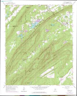
Vandiver Topo Map Alabama
To zoom in, hover over the map of Vandiver
USGS Topo Quad 33086d5 - 1:24,000 scale
| Topo Map Name: | Vandiver |
| USGS Topo Quad ID: | 33086d5 |
| Print Size: | ca. 21 1/4" wide x 27" high |
| Southeast Coordinates: | 33.375° N latitude / 86.5° W longitude |
| Map Center Coordinates: | 33.4375° N latitude / 86.5625° W longitude |
| U.S. State: | AL |
| Filename: | o33086d5.jpg |
| Download Map JPG Image: | Vandiver topo map 1:24,000 scale |
| Map Type: | Topographic |
| Topo Series: | 7.5´ |
| Map Scale: | 1:24,000 |
| Source of Map Images: | United States Geological Survey (USGS) |
| Alternate Map Versions: |
Vandiver AL 1959, updated 1960 Download PDF Buy paper map Vandiver AL 1959, updated 1960 Download PDF Buy paper map Vandiver AL 1959, updated 1971 Download PDF Buy paper map Vandiver AL 1959, updated 1978 Download PDF Buy paper map Vandiver AL 1959, updated 1978 Download PDF Buy paper map Vandiver AL 1975, updated 1977 Download PDF Buy paper map Vandiver AL 2011 Download PDF Buy paper map Vandiver AL 2014 Download PDF Buy paper map |
1:24,000 Topo Quads surrounding Vandiver
> Back to 33086a1 at 1:100,000 scale
> Back to 33086a1 at 1:250,000 scale
> Back to U.S. Topo Maps home
Vandiver topo map: Gazetteer
Vandiver: Capes
Baker Point elevation 358m 1174′Vandiver: Cliffs
Laurel Point elevation 421m 1381′Vandiver: Dams
Chelsea Game Preserve Lake Dam elevation 177m 580′Davis Lake Dam Number Two elevation 163m 534′
Finger Lake Dam elevation 224m 734′
Lake Wehapa Dam elevation 208m 682′
North Valley View Lake Dam elevation 162m 531′
Pless Lake Dam elevation 159m 521′
Saunders Lake Dam elevation 171m 561′
Shelton Lake Dam elevation 147m 482′
Smyer Lake Dam Number Two elevation 221m 725′
Smyers Lake Dam Number One elevation 222m 728′
Valley View Lake Dam elevation 162m 531′
Yielding Lake Dam elevation 163m 534′
Vandiver: Gaps
Devils Gap elevation 268m 879′Lowry Gap elevation 322m 1056′
Rattlesnake Gap elevation 180m 590′
Rock Cutter Gap elevation 153m 501′
Shephard Gap elevation 313m 1026′
Wyatts Gap elevation 305m 1000′
Vandiver: Lakes
Cedar Lake elevation 221m 725′Chelsea Game Preserve Lake elevation 168m 551′
Great Pine Lake elevation 220m 721′
Mountain View Lake elevation 159m 521′
Spring Lake elevation 240m 787′
Valley Lake elevation 208m 682′
Valley View Lake elevation 162m 531′
Vandiver: Populated Places
Dunavant elevation 203m 666′Vandiver elevation 162m 531′
Vandiver: Post Offices
Vandiver Post Office elevation 165m 541′Vandiver: Reservoirs
Alpines Lakes elevation 223m 731′Crystal Lake elevation 211m 692′
Finger Lake elevation 218m 715′
Hollybrook Lake elevation 222m 728′
Kerscoha Lake elevation 213m 698′
Lake Gorman elevation 171m 561′
Little Deer Lakes elevation 224m 734′
Mirror Lakes elevation 221m 725′
Moore Lake elevation 163m 534′
North Valley View Lake elevation 162m 531′
Shelton Lake elevation 147m 482′
Twin Pine Lake elevation 159m 521′
Wehapa Lake elevation 208m 682′
Yielding Lake elevation 163m 534′
Vandiver: Ridges
Coosa Mountain elevation 341m 1118′Double Oak Mountain elevation 395m 1295′
Pine Mountain elevation 291m 954′
Potato Ridge elevation 276m 905′
Rock Ridge elevation 202m 662′
Straight Ridge elevation 174m 570′
Vandiver: Streams
Anders Branch elevation 163m 534′Big Branch elevation 183m 600′
Bob Hood Branch elevation 149m 488′
Brasher Branch elevation 172m 564′
Holmes Branch elevation 167m 547′
Indian Creek elevation 142m 465′
Shephard Branch elevation 170m 557′
Spouting Spring Branch elevation 208m 682′
Tunnel Branch elevation 144m 472′
Weldon Branch elevation 164m 538′
Vandiver: Summits
Penitentiary Mountain elevation 375m 1230′Sand Mountain elevation 447m 1466′
Signal Mountain elevation 460m 1509′
Vandiver: Tunnels
Coosa Tunnel elevation 331m 1085′Vandiver: Valleys
The Penitentiary elevation 260m 853′Vandiver digital topo map on disk
Buy this Vandiver topo map showing relief, roads, GPS coordinates and other geographical features, as a high-resolution digital map file on DVD:


