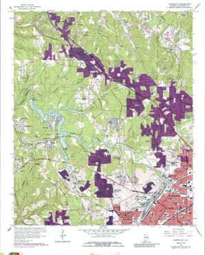
Adamsville Topo Map Alabama
To zoom in, hover over the map of Adamsville
USGS Topo Quad 33086e8 - 1:24,000 scale
| Topo Map Name: | Adamsville |
| USGS Topo Quad ID: | 33086e8 |
| Print Size: | ca. 21 1/4" wide x 27" high |
| Southeast Coordinates: | 33.5° N latitude / 86.875° W longitude |
| Map Center Coordinates: | 33.5625° N latitude / 86.9375° W longitude |
| U.S. State: | AL |
| Filename: | o33086e8.jpg |
| Download Map JPG Image: | Adamsville topo map 1:24,000 scale |
| Map Type: | Topographic |
| Topo Series: | 7.5´ |
| Map Scale: | 1:24,000 |
| Source of Map Images: | United States Geological Survey (USGS) |
| Alternate Map Versions: |
Adamsville AL 1959, updated 1960 Download PDF Buy paper map Adamsville AL 1959, updated 1971 Download PDF Buy paper map Adamsville AL 1959, updated 1978 Download PDF Buy paper map Adamsville AL 1959, updated 1987 Download PDF Buy paper map Adamsville AL 1975, updated 1977 Download PDF Buy paper map Adamsville AL 1993, updated 1998 Download PDF Buy paper map Adamsville AL 2011 Download PDF Buy paper map Adamsville AL 2014 Download PDF Buy paper map |
1:24,000 Topo Quads surrounding Adamsville
> Back to 33086e1 at 1:100,000 scale
> Back to 33086a1 at 1:250,000 scale
> Back to U.S. Topo Maps home
Adamsville topo map: Gazetteer
Adamsville: Airports
Simmons Airport elevation 196m 643′Adamsville: Crossings
Interchange 120 elevation 164m 538′Interchange 121 elevation 170m 557′
Adamsville: Dams
Bayview Lake Dam elevation 149m 488′Adamsville: Falls
Village Falls elevation 154m 505′Adamsville: Islands
Knowles Island elevation 162m 531′Adamsville: Mines
Bayview Mine elevation 149m 488′Blossburg East Mine elevation 189m 620′
Blossburg Mine elevation 120m 393′
Cooks Mine elevation 205m 672′
Docena Slope Mine elevation 192m 629′
Dolomite Mine elevation 193m 633′
Dolomite Number 1 Slope Mine elevation 203m 666′
Dolomite Number 2 Mine elevation 200m 656′
Edgewater Shaft Mine elevation 202m 662′
Hamilton Mine elevation 189m 620′
Lindbergh Number 6 Mine elevation 126m 413′
McArdle Mine elevation 170m 557′
Pratt Mines elevation 164m 538′
Reids Mine elevation 145m 475′
Republic Mine elevation 133m 436′
Rock Slope Number 4 Mine elevation 170m 557′
Warner Mine elevation 197m 646′
Woodruff Mill Mine elevation 155m 508′
Wylam Mine elevation 207m 679′
Adamsville: Parks
Adamsville Park elevation 174m 570′Ensley Park elevation 163m 534′
Exchange Park elevation 169m 554′
Fairview Park elevation 200m 656′
Highlands Park elevation 193m 633′
MacAlpin Park elevation 158m 518′
Pratt City Carline Historic District elevation 173m 567′
Tuxedo Park elevation 158m 518′
Wylam Park elevation 175m 574′
Adamsville: Populated Places
Adamsville elevation 176m 577′Bay View elevation 165m 541′
Crockard Junction elevation 183m 600′
Crumley Chapel elevation 184m 603′
Daisey City elevation 128m 419′
Daisey City Trailer Park elevation 131m 429′
Docena elevation 186m 610′
Dogtown elevation 134m 439′
Edgewater elevation 162m 531′
Edgewater Junction elevation 161m 528′
Ensley elevation 161m 528′
Ensley Highlands elevation 186m 610′
Exum elevation 196m 643′
Falls Junction elevation 188m 616′
Forest View Estates elevation 212m 695′
Forestdale elevation 197m 646′
Forestdale by the Brook elevation 140m 459′
Forestdale Mobile Home Park elevation 121m 396′
Frenchtown elevation 162m 531′
Glasgow elevation 176m 577′
Grays Gardens elevation 179m 587′
Graysville elevation 170m 557′
Graysville Heights elevation 173m 567′
Hillcrest Estates elevation 203m 666′
Hillview elevation 198m 649′
Hobson elevation 195m 639′
Little Italy elevation 160m 524′
Longview Estates elevation 178m 583′
Longview Mobile Home Park elevation 178m 583′
Maytown elevation 216m 708′
McDonald Chapel elevation 178m 583′
Merrywood elevation 199m 652′
Midway elevation 197m 646′
Minor elevation 177m 580′
Mulga elevation 175m 574′
Mulga Mine elevation 167m 547′
New Town elevation 128m 419′
Oakwood elevation 182m 597′
Red Wine elevation 166m 544′
Republic elevation 125m 410′
Sandusky elevation 170m 557′
Scarlet Town elevation 120m 393′
Shadyside elevation 169m 554′
Sherman Heights elevation 186m 610′
Sherwood Hills elevation 177m 580′
Sunset Mountain elevation 184m 603′
The Drifttracks elevation 192m 629′
Tuxedo Heights elevation 170m 557′
Union Grove elevation 184m 603′
Village Creek Junction elevation 164m 538′
West Ensley elevation 190m 623′
Westchester Estates elevation 196m 643′
Westwood elevation 184m 603′
Westwood Garden Estates elevation 190m 623′
Westwood Trailer Court elevation 196m 643′
Wylam elevation 200m 656′
Adamsville: Reservoirs
Bayview Lake elevation 149m 488′Adamsville: Ridges
Glasgow Ridge elevation 181m 593′Adamsville: Springs
Shugart Springs elevation 202m 662′Adamsville: Streams
Black Creek elevation 152m 498′Camp Branch elevation 149m 488′
Corbet Branch elevation 149m 488′
Fields Branch elevation 116m 380′
Second Creek elevation 151m 495′
Venison Branch elevation 128m 419′
Adamsville: Summits
Cat Mountain elevation 213m 698′Irish Hill elevation 196m 643′
Adamsville: Valleys
Goolsby Hollow elevation 123m 403′Hanty Hollow elevation 122m 400′
Harden Hollow elevation 132m 433′
Jacob Hollow elevation 133m 436′
Morris Hollow elevation 129m 423′
Adamsville digital topo map on disk
Buy this Adamsville topo map showing relief, roads, GPS coordinates and other geographical features, as a high-resolution digital map file on DVD:


