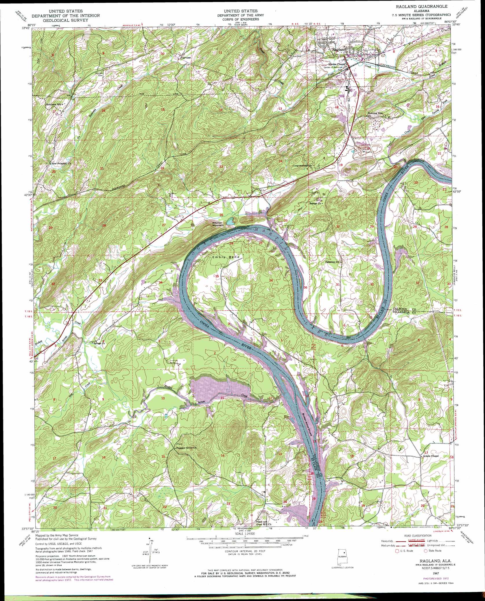
Ragland Topo Map Alabama
To zoom in, hover over the map of Ragland
USGS Topo Quad 33086f2 - 1:24,000 scale
| Topo Map Name: | Ragland |
| USGS Topo Quad ID: | 33086f2 |
| Print Size: | ca. 21 1/4" wide x 27" high |
| Southeast Coordinates: | 33.625° N latitude / 86.125° W longitude |
| Map Center Coordinates: | 33.6875° N latitude / 86.1875° W longitude |
| U.S. State: | AL |
| Filename: | o33086f2.jpg |
| Download Map JPG Image: | Ragland topo map 1:24,000 scale |
| Map Type: | Topographic |
| Topo Series: | 7.5´ |
| Map Scale: | 1:24,000 |
| Source of Map Images: | United States Geological Survey (USGS) |
| Alternate Map Versions: |
Ragland AL 1947, updated 1953 Download PDF Buy paper map Ragland AL 1947, updated 1973 Download PDF Buy paper map Ragland AL 1947, updated 1973 Download PDF Buy paper map Ragland AL 1975, updated 1977 Download PDF Buy paper map Ragland AL 2011 Download PDF Buy paper map Ragland AL 2014 Download PDF Buy paper map |
1:24,000 Topo Quads surrounding Ragland
Oneonta |
Hyatt Gap |
Steele |
Dunaway Mountain |
Glencoe |
Springville |
Ashville |
Cox Gap |
Ohatchee |
Wellington |
Odenville |
Wattsville |
Ragland |
Francis Mill |
Eulaton |
Cooks Springs |
Pell City |
Riverside |
Eastaboga |
Munford |
Vincent |
Laniers |
Sleeping Giants |
Talladega |
Ironaton |
> Back to 33086e1 at 1:100,000 scale
> Back to 33086a1 at 1:250,000 scale
> Back to U.S. Topo Maps home
Ragland topo map: Gazetteer
Ragland: Bars
Box Shoals (historical) elevation 142m 465′Broken Arrow Shoals elevation 142m 465′
Ragland: Bends
Embry Bend elevation 179m 587′Kirkseys Bend elevation 142m 465′
Ragland: Crossings
Greens Mill (historical) elevation 142m 465′Mitchells Ferry (historical) elevation 142m 465′
Woods Ferry (historical) elevation 142m 465′
Ragland: Dams
Lock Four (historical) elevation 142m 465′National Dam elevation 160m 524′
Ragland: Islands
Denson Island (historical) elevation 142m 465′McCoys Island (historical) elevation 142m 465′
Ragland: Populated Places
Embry Bend elevation 165m 541′Fairview elevation 177m 580′
Ragland elevation 171m 561′
Sherwood Shores elevation 148m 485′
Ragland: Post Offices
Ragland Post Office elevation 157m 515′Ragland: Reservoirs
National Lake elevation 160m 524′Ragland: Streams
Arnold Branch elevation 142m 465′Blue Spring Fork elevation 143m 469′
Broken Arrow Creek elevation 142m 465′
Bruner Creek elevation 161m 528′
Dry Creek elevation 146m 479′
Green Branch elevation 148m 485′
Leather Creek elevation 152m 498′
No Business Creek elevation 151m 495′
Trout Creek elevation 142m 465′
Ragland: Summits
Henderson Mountain elevation 232m 761′Mitchell Mountain elevation 227m 744′
Ragland: Valleys
Starvation Valley elevation 165m 541′Ragland digital topo map on disk
Buy this Ragland topo map showing relief, roads, GPS coordinates and other geographical features, as a high-resolution digital map file on DVD: