Odenville Topo Map Alabama
To zoom in, hover over the map of Odenville
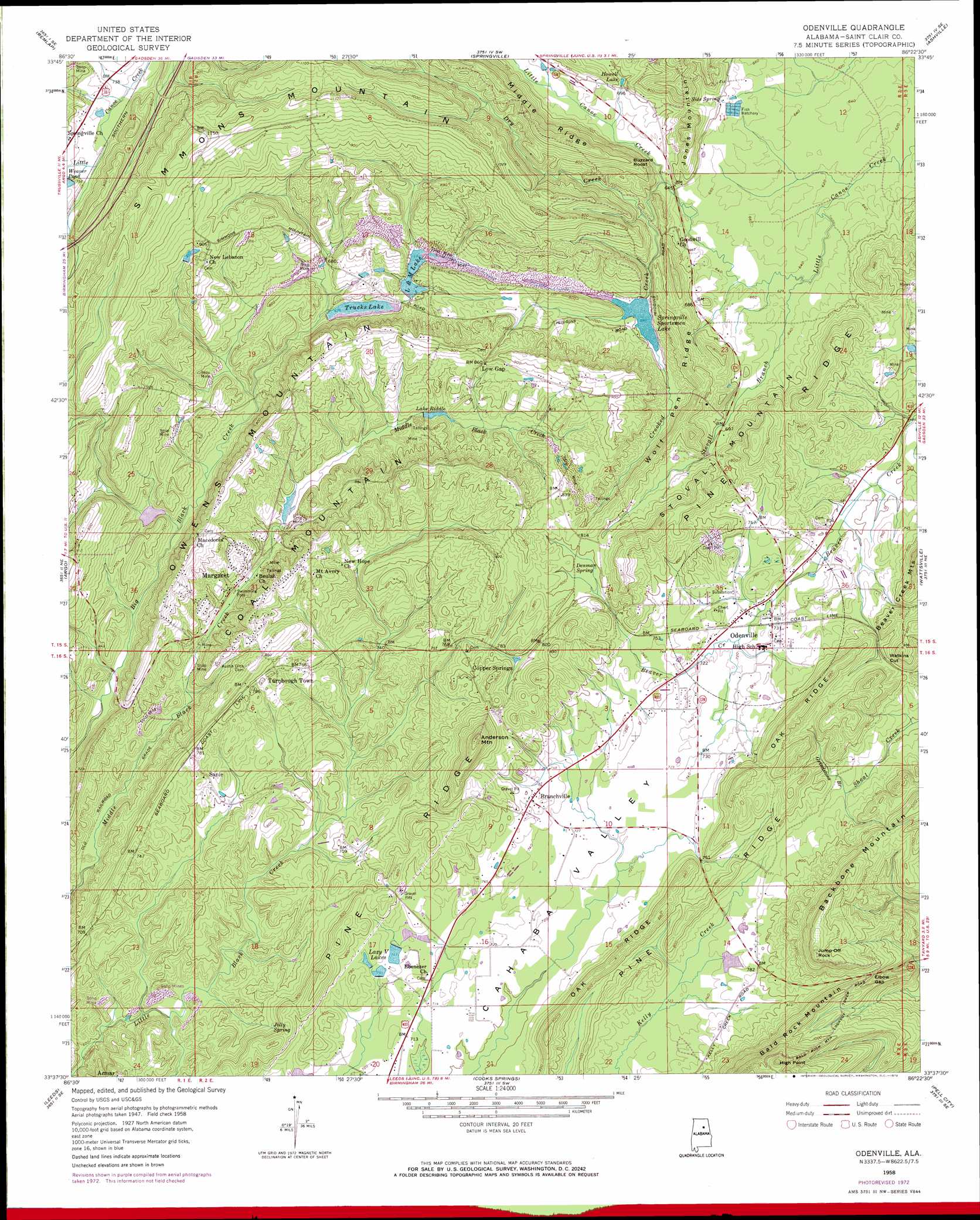
USGS Topo Quad 33086f4 - 1:24,000 scale
| Topo Map Name: | Odenville |
| USGS Topo Quad ID: | 33086f4 |
| Print Size: | ca. 21 1/4" wide x 27" high |
| Southeast Coordinates: | 33.625° N latitude / 86.375° W longitude |
| Map Center Coordinates: | 33.6875° N latitude / 86.4375° W longitude |
| U.S. State: | AL |
| Filename: | o33086f4.jpg |
| Download Map JPG Image: | Odenville topo map 1:24,000 scale |
| Map Type: | Topographic |
| Topo Series: | 7.5´ |
| Map Scale: | 1:24,000 |
| Source of Map Images: | United States Geological Survey (USGS) |
| Alternate Map Versions: |
Odenville AL 1958, updated 1960 Download PDF Buy paper map Odenville AL 1958, updated 1973 Download PDF Buy paper map Odenville AL 1975, updated 1977 Download PDF Buy paper map Odenville AL 2011 Download PDF Buy paper map Odenville AL 2014 Download PDF Buy paper map |
1:24,000 Topo Quads surrounding Odenville
Nectar |
Cleveland |
Oneonta |
Hyatt Gap |
Steele |
Trafford |
Remlap |
Springville |
Ashville |
Cox Gap |
Pinson |
Argo |
Odenville |
Wattsville |
Ragland |
Irondale |
Leeds |
Cooks Springs |
Pell City |
Riverside |
Cahaba Heights |
Vandiver |
Vincent |
Laniers |
Sleeping Giants |
> Back to 33086e1 at 1:100,000 scale
> Back to 33086a1 at 1:250,000 scale
> Back to U.S. Topo Maps home
Odenville topo map: Gazetteer
Odenville: Cliffs
Buzzard Roost elevation 275m 902′Odenville: Dams
Catfish Lake Dam elevation 222m 728′Clayton Dam elevation 229m 751′
L and M Dam elevation 211m 692′
Lazy V Ranch Dam elevation 230m 754′
Martin Dam elevation 192m 629′
Qsl Fish Hatchery Dam elevation 232m 761′
Riddle Dam elevation 219m 718′
Springville Sportsman Dam elevation 211m 692′
Trucks Dam elevation 206m 675′
Odenville: Gaps
Elbow Gap elevation 279m 915′Watkins Cut elevation 249m 816′
Odenville: Mines
Acmar Mines elevation 209m 685′Brookston Mine elevation 255m 836′
Foremans Mine elevation 242m 793′
Margaret Mine elevation 241m 790′
Odenville: Populated Places
Branchville elevation 271m 889′Copper Springs elevation 244m 800′
Crockertown elevation 225m 738′
Green Acres Estates elevation 226m 741′
Havilah Hills Estates elevation 254m 833′
Hill Number 1 elevation 269m 882′
Hill Number 2 elevation 274m 898′
Lazy V Lake Acres elevation 224m 734′
Margaret elevation 207m 679′
Odenville elevation 225m 738′
Sanie elevation 220m 721′
Shady Acres elevation 237m 777′
Turnbough Town elevation 243m 797′
Woody Acres elevation 235m 770′
Odenville: Post Offices
Margaret Post Office elevation 207m 679′Odenville: Reservoirs
Clayton Lake elevation 229m 751′Howell Lake elevation 213m 698′
L and M Lake elevation 211m 692′
Lake Melanie elevation 222m 728′
Lake Riddle elevation 215m 705′
Land M Lake elevation 207m 679′
Lazy V Lake elevation 226m 741′
Margaret Lake elevation 207m 679′
Martin Lake elevation 192m 629′
Qsl Fish Hatchery Lake elevation 232m 761′
Springville Sportsmen Lake elevation 211m 692′
Trucks Lake elevation 201m 659′
Odenville: Ridges
Oak Ridge elevation 268m 879′Pine Ridge elevation 284m 931′
Pine Ridge elevation 243m 797′
Wolf Pen Ridge elevation 258m 846′
Odenville: Springs
Denman Spring elevation 239m 784′Jolly Spring elevation 231m 757′
Side Spring elevation 213m 698′
Odenville: Streams
Crooked Creek elevation 197m 646′Dry Creek elevation 211m 692′
Grindstone Branch elevation 220m 721′
Stovall Branch elevation 189m 620′
Odenville: Summits
Anderson Mountain elevation 341m 1118′Coal Mountain elevation 293m 961′
High Point elevation 399m 1309′
Jump-Off Rock elevation 362m 1187′
Simmons Mountain elevation 356m 1167′
Stovall Mountain elevation 240m 787′
Odenville digital topo map on disk
Buy this Odenville topo map showing relief, roads, GPS coordinates and other geographical features, as a high-resolution digital map file on DVD: