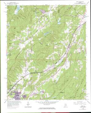
Argo Topo Map Alabama
To zoom in, hover over the map of Argo
USGS Topo Quad 33086f5 - 1:24,000 scale
| Topo Map Name: | Argo |
| USGS Topo Quad ID: | 33086f5 |
| Print Size: | ca. 21 1/4" wide x 27" high |
| Southeast Coordinates: | 33.625° N latitude / 86.5° W longitude |
| Map Center Coordinates: | 33.6875° N latitude / 86.5625° W longitude |
| U.S. State: | AL |
| Filename: | o33086f5.jpg |
| Download Map JPG Image: | Argo topo map 1:24,000 scale |
| Map Type: | Topographic |
| Topo Series: | 7.5´ |
| Map Scale: | 1:24,000 |
| Source of Map Images: | United States Geological Survey (USGS) |
| Alternate Map Versions: |
Argo AL 1959, updated 1960 Download PDF Buy paper map Argo AL 1959, updated 1960 Download PDF Buy paper map Argo AL 1959, updated 1971 Download PDF Buy paper map Argo AL 1959, updated 1985 Download PDF Buy paper map Argo AL 1959, updated 1985 Download PDF Buy paper map Argo AL 1975, updated 1977 Download PDF Buy paper map Argo AL 2011 Download PDF Buy paper map Argo AL 2014 Download PDF Buy paper map |
1:24,000 Topo Quads surrounding Argo
> Back to 33086e1 at 1:100,000 scale
> Back to 33086a1 at 1:250,000 scale
> Back to U.S. Topo Maps home
Argo topo map: Gazetteer
Argo: Crossings
Interchange 141 elevation 258m 846′Interchange 148 elevation 254m 833′
Argo: Dams
Cahaba River Lake Dam elevation 261m 856′Echo Lake Dam elevation 323m 1059′
Hilldale Farm Lake Dam elevation 238m 780′
Hubbards Lake Dam elevation 226m 741′
J M Roberts Pond Dam elevation 241m 790′
Lake in the Woods Dam elevation 289m 948′
Little Cahaba Creek Lake Dam elevation 216m 708′
Minith Dam elevation 285m 935′
Quickhaven Lake Dam elevation 266m 872′
Riggins Pond Dam elevation 230m 754′
Tadpole Dam elevation 259m 849′
Watkins Dam elevation 226m 741′
Wild Acres Lake Dam elevation 237m 777′
Windsong Lake Dam elevation 202m 662′
Argo: Gaps
Lawless Gap elevation 310m 1017′Ware Gap elevation 306m 1003′
Argo: Lakes
Hubbards Lake elevation 231m 757′Argo: Mines
Vann Quarry elevation 222m 728′Worthington Ore Mines elevation 311m 1020′
Argo: Parks
Zamora Park elevation 292m 958′Argo: Populated Places
Argo elevation 248m 813′Ayres elevation 319m 1046′
Ayres Estates elevation 323m 1059′
Breakstone Village elevation 236m 774′
Cahaba Crest elevation 240m 787′
Cahaba Village elevation 215m 705′
Candlewood Lakes elevation 296m 971′
Clay elevation 285m 935′
Confederate Estates elevation 299m 980′
Cotton Ridge elevation 250m 820′
Countryside Estates elevation 296m 971′
Dogwood Estates elevation 325m 1066′
Eagle Ridge elevation 267m 875′
East Trussville (historical) elevation 241m 790′
Echo Hills elevation 258m 846′
Meadowview Estates elevation 239m 784′
Misty Pines elevation 255m 836′
Moss Rock elevation 234m 767′
Near Acres Estates elevation 279m 915′
Parsons elevation 197m 646′
Roddams Trailer Park elevation 237m 777′
Rolling Hills elevation 267m 875′
Saddlewood elevation 232m 761′
Sherman Oaks elevation 251m 823′
Southern Acres elevation 243m 797′
Sunnyside elevation 306m 1003′
Vanns elevation 242m 793′
West Ridge elevation 307m 1007′
Woodward elevation 237m 777′
Argo: Post Offices
Clay Post Office elevation 289m 948′Argo: Reservoirs
Canoe Creek Lake elevation 289m 948′Circle Three Lakes elevation 291m 954′
Echo Lake elevation 316m 1036′
Hidden Valley Lake elevation 261m 856′
Holcomb Lake elevation 216m 708′
J M Roberts Pond elevation 241m 790′
Lake in the Woods elevation 293m 961′
Liles Lake elevation 290m 951′
Minith Lake elevation 285m 935′
Quickhaven Lake elevation 265m 869′
Riggins Pond elevation 230m 754′
Tadpole Lake elevation 259m 849′
Weaver Pond elevation 232m 761′
Wilborn Lake elevation 226m 741′
Wild Acres Lake elevation 232m 761′
Windsong Lake elevation 210m 688′
Zamora Park Lake elevation 266m 872′
Argo: Ridges
Blackjack Ridge elevation 295m 967′Chinquapir Ridge elevation 354m 1161′
Owens Mountain elevation 232m 761′
Pine Ridge elevation 351m 1151′
Rocky Ridge elevation 304m 997′
Argo: Springs
Reid Spring elevation 244m 800′Argo: Streams
Clear Branch elevation 231m 757′Dillashaw Branch elevation 257m 843′
Dry Creek elevation 212m 695′
Knox Branch elevation 217m 711′
Mill Creek elevation 224m 734′
Wadie Branch elevation 247m 810′
Argo: Summits
Black Oak Mountain elevation 413m 1354′Butler Mountain elevation 430m 1410′
Cahaba Mountain elevation 419m 1374′
Cedar Mountain elevation 338m 1108′
Foster Mountain elevation 421m 1381′
Hall Mountain elevation 381m 1250′
Hayes Mountain elevation 400m 1312′
Meridian Knob elevation 284m 931′
Meridian Mountain elevation 395m 1295′
Praytor Mountain elevation 411m 1348′
Argo: Valleys
Happy Hollow elevation 224m 734′Vann Valley elevation 251m 823′
Argo digital topo map on disk
Buy this Argo topo map showing relief, roads, GPS coordinates and other geographical features, as a high-resolution digital map file on DVD:


