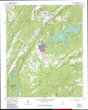
Remlap Topo Map Alabama
To zoom in, hover over the map of Remlap
USGS Topo Quad 33086g5 - 1:24,000 scale
| Topo Map Name: | Remlap |
| USGS Topo Quad ID: | 33086g5 |
| Print Size: | ca. 21 1/4" wide x 27" high |
| Southeast Coordinates: | 33.75° N latitude / 86.5° W longitude |
| Map Center Coordinates: | 33.8125° N latitude / 86.5625° W longitude |
| U.S. State: | AL |
| Filename: | o33086g5.jpg |
| Download Map JPG Image: | Remlap topo map 1:24,000 scale |
| Map Type: | Topographic |
| Topo Series: | 7.5´ |
| Map Scale: | 1:24,000 |
| Source of Map Images: | United States Geological Survey (USGS) |
| Alternate Map Versions: |
Remlap AL 1960, updated 1963 Download PDF Buy paper map Remlap AL 1960, updated 1971 Download PDF Buy paper map Remlap AL 1960, updated 1977 Download PDF Buy paper map Remlap AL 1960, updated 1978 Download PDF Buy paper map Remlap AL 1960, updated 1986 Download PDF Buy paper map Remlap AL 1960, updated 1986 Download PDF Buy paper map Remlap AL 1975, updated 1977 Download PDF Buy paper map Remlap AL 2011 Download PDF Buy paper map Remlap AL 2014 Download PDF Buy paper map |
1:24,000 Topo Quads surrounding Remlap
> Back to 33086e1 at 1:100,000 scale
> Back to 33086a1 at 1:250,000 scale
> Back to U.S. Topo Maps home
Remlap topo map: Gazetteer
Remlap: Dams
Adams Lake Dam elevation 311m 1020′Golden Dam elevation 309m 1013′
Inland Lake elevation 247m 810′
Inland Lake Dam elevation 246m 807′
Mountain Lake Dam elevation 219m 718′
Pittman Lakes Dam Number 2 elevation 228m 748′
Springville Estate Dam elevation 220m 721′
Tekawitha Dam elevation 239m 784′
Woodhaven Lake Dam elevation 281m 921′
Zamora Lake Dam elevation 232m 761′
Remlap: Gaps
Cowden Gap elevation 249m 816′Johnson Gap elevation 211m 692′
Posey Gap elevation 372m 1220′
Reese Gap elevation 300m 984′
River Gap elevation 179m 587′
Tucker Gap elevation 299m 980′
Waid Gap elevation 228m 748′
Remlap: Mines
Cowden Gap Mine elevation 274m 898′Remlap: Populated Places
Clear Springs elevation 209m 685′Inland Junction elevation 183m 600′
Pine Mountain elevation 315m 1033′
Remlap elevation 226m 741′
Springville Lake Estates elevation 224m 734′
Watseka (historical) elevation 208m 682′
Remlap: Post Offices
Remlap Post Office elevation 228m 748′Viola Post Office (historical) elevation 189m 620′
Remlap: Reservoirs
Adams Lake elevation 311m 1020′Golden Lake elevation 306m 1003′
Inland Lake elevation 239m 784′
Lake Pittman elevation 228m 748′
Mountain Lake elevation 217m 711′
Rocking H Ranch Lake elevation 309m 1013′
Springville Lake elevation 220m 721′
Tekawitha Lake elevation 239m 784′
Woodhaven Lake elevation 277m 908′
Zamora Lake elevation 236m 774′
Remlap: Ridges
Gravelly Ridge elevation 303m 994′Pine Mountain elevation 434m 1423′
Sand Ridge elevation 298m 977′
Remlap: Streams
Bear Mountain Branch elevation 248m 813′Campbell Creek elevation 177m 580′
Fall Branch elevation 220m 721′
Jones Slough elevation 239m 784′
Rock Creek elevation 239m 784′
Sally Branch elevation 176m 577′
Sawmill Slough elevation 239m 784′
Valley Creek elevation 177m 580′
Remlap: Summits
Bear Mountain elevation 400m 1312′Saint Clair Mountain elevation 414m 1358′
Village Mountain elevation 409m 1341′
Remlap: Valleys
Clayton Cove elevation 294m 964′Nedham Hollow elevation 239m 784′
Wald Hollow elevation 239m 784′
Remlap digital topo map on disk
Buy this Remlap topo map showing relief, roads, GPS coordinates and other geographical features, as a high-resolution digital map file on DVD:


