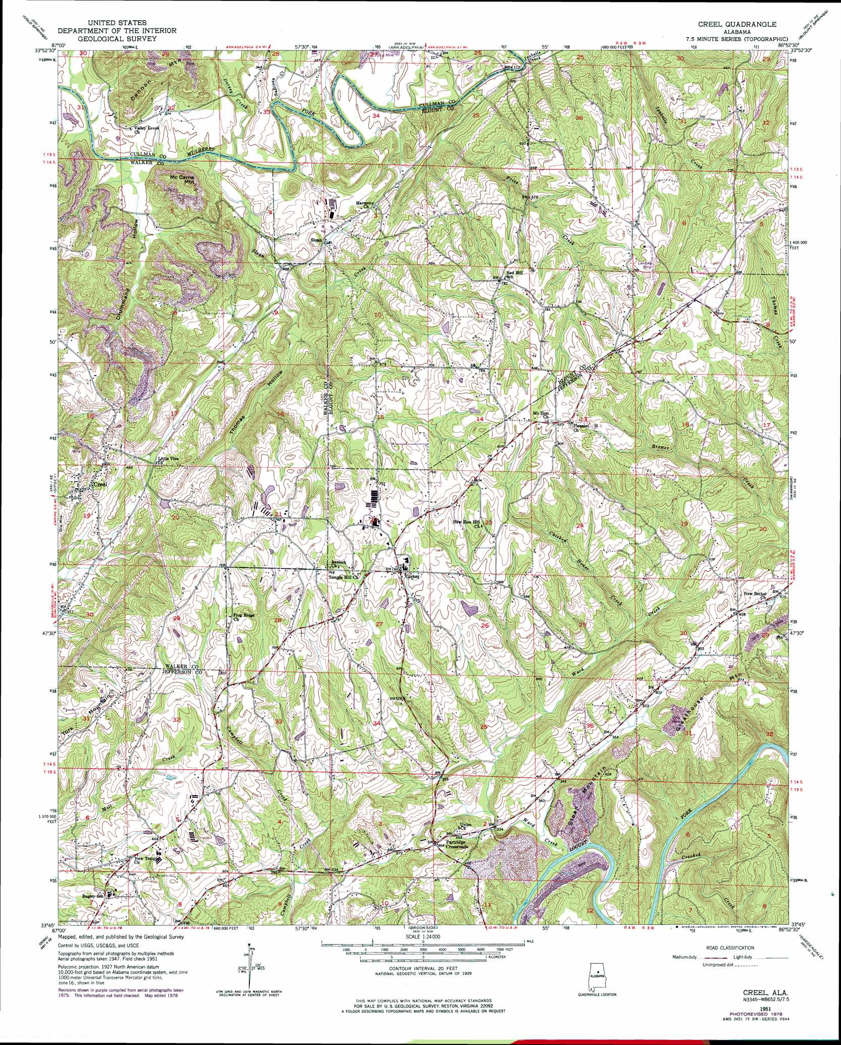
Creel Topo Map Alabama
To zoom in, hover over the map of Creel
USGS Topo Quad 33086g8 - 1:24,000 scale
| Topo Map Name: | Creel |
| USGS Topo Quad ID: | 33086g8 |
| Print Size: | ca. 21 1/4" wide x 27" high |
| Southeast Coordinates: | 33.75° N latitude / 86.875° W longitude |
| Map Center Coordinates: | 33.8125° N latitude / 86.9375° W longitude |
| U.S. State: | AL |
| Filename: | o33086g8.jpg |
| Download Map JPG Image: | Creel topo map 1:24,000 scale |
| Map Type: | Topographic |
| Topo Series: | 7.5´ |
| Map Scale: | 1:24,000 |
| Source of Map Images: | United States Geological Survey (USGS) |
| Alternate Map Versions: |
Creel AL 1951, updated 1952 Download PDF Buy paper map Creel AL 1951, updated 1971 Download PDF Buy paper map Creel AL 1951, updated 1978 Download PDF Buy paper map Creel AL 1975, updated 1977 Download PDF Buy paper map Creel AL 2011 Download PDF Buy paper map Creel AL 2014 Download PDF Buy paper map |
1:24,000 Topo Quads surrounding Creel
Arley |
Crane Hill |
Trimble |
Hanceville |
Garden City |
Sunlight |
Cold Springs |
Arkadelphia |
Blount Springs |
Nectar |
Cordova |
Sipsey |
Creel |
Warrior |
Trafford |
Goodsprings |
Dora |
Brookside |
Gardendale |
Pinson |
Gilmore |
Sylvan Springs |
Adamsville |
Birmingham North |
Irondale |
> Back to 33086e1 at 1:100,000 scale
> Back to 33086a1 at 1:250,000 scale
> Back to U.S. Topo Maps home
Creel topo map: Gazetteer
Creel: Crossings
Sullivan Ford elevation 88m 288′Creel: Mines
Beltona Mine elevation 146m 479′Bohannon Mine elevation 108m 354′
Carpet Rock Mine elevation 122m 400′
Empire Number 2 Mine elevation 140m 459′
Knob Mine elevation 200m 656′
Knob Mine Number 2 elevation 113m 370′
Wylam Number 4 Mine elevation 132m 433′
Creel: Parks
Hollow Hills Park elevation 171m 561′Creel: Populated Places
Bagley Meadows elevation 182m 597′Corner elevation 220m 721′
Creel elevation 165m 541′
Partridge Crossroads elevation 123m 403′
Red Hill elevation 238m 780′
Sloan elevation 128m 419′
Willow Grove Estates elevation 210m 688′
York Mountain elevation 231m 757′
Creel: Streams
Chicken House Creek elevation 110m 360′Crooked Creek elevation 89m 291′
Dorsey Creek elevation 85m 278′
Gleade Branch elevation 99m 324′
Isabelle Creek elevation 93m 305′
Price Creek elevation 91m 298′
Sloan Creek elevation 87m 285′
Sullivan Creek elevation 87m 285′
Ward Creek elevation 90m 295′
Creel: Summits
Greathouse Mountain elevation 202m 662′McCarne Mountain elevation 184m 603′
Sloan Mountain elevation 197m 646′
York Mountain elevation 220m 721′
Creel: Valleys
Drummond Hollow elevation 88m 288′Thomas Hollow elevation 92m 301′
Creel digital topo map on disk
Buy this Creel topo map showing relief, roads, GPS coordinates and other geographical features, as a high-resolution digital map file on DVD: