West Blocton West Topo Map Alabama
To zoom in, hover over the map of West Blocton West
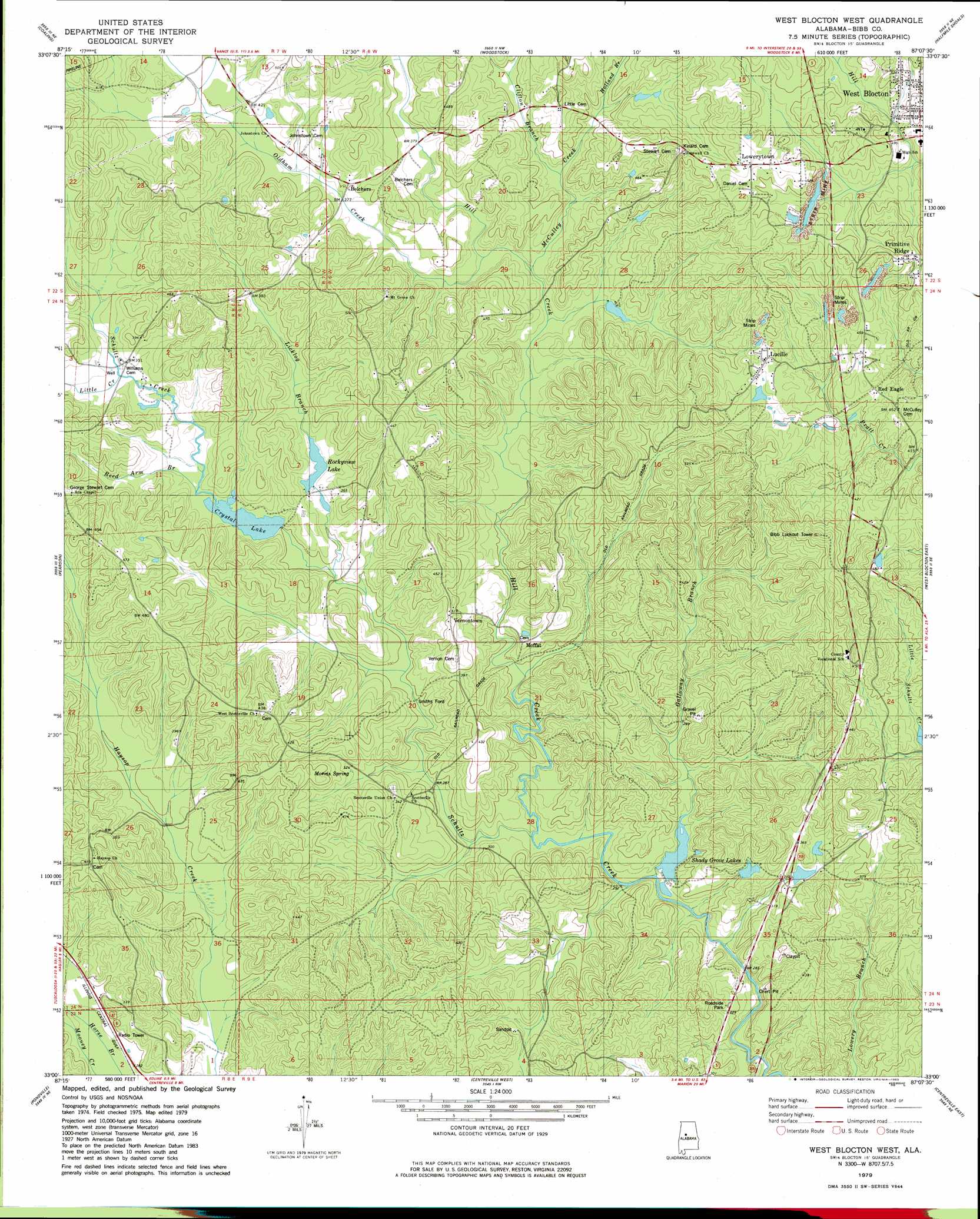
USGS Topo Quad 33087a2 - 1:24,000 scale
| Topo Map Name: | West Blocton West |
| USGS Topo Quad ID: | 33087a2 |
| Print Size: | ca. 21 1/4" wide x 27" high |
| Southeast Coordinates: | 33° N latitude / 87.125° W longitude |
| Map Center Coordinates: | 33.0625° N latitude / 87.1875° W longitude |
| U.S. State: | AL |
| Filename: | o33087a2.jpg |
| Download Map JPG Image: | West Blocton West topo map 1:24,000 scale |
| Map Type: | Topographic |
| Topo Series: | 7.5´ |
| Map Scale: | 1:24,000 |
| Source of Map Images: | United States Geological Survey (USGS) |
| Alternate Map Versions: |
West Blocton West AL 1979, updated 1980 Download PDF Buy paper map West Blocton West AL 2011 Download PDF Buy paper map West Blocton West AL 2014 Download PDF Buy paper map |
1:24,000 Topo Quads surrounding West Blocton West
Lake Nicol |
Brookwood |
Abernant |
Mccalla |
Greenwood |
Cottondale |
Coaling |
Woodstock |
Halfmile Shoals |
Pea Ridge |
Duncanville |
Pearson |
West Blocton West |
West Blocton East |
Aldrich |
Payne Lake |
Pondville |
Centreville West |
Centreville East |
Randolph |
Hogglesville |
Heiberger |
Harrisburg |
Oakmulgee |
Maplesville West |
> Back to 33087a1 at 1:100,000 scale
> Back to 33086a1 at 1:250,000 scale
> Back to U.S. Topo Maps home
West Blocton West topo map: Gazetteer
West Blocton West: Crossings
Shallow Ford elevation 89m 291′Smiths Ford elevation 85m 278′
West Blocton West: Dams
Chase Lake Dam elevation 92m 301′Pearson Lake Dam elevation 102m 334′
Shady Grove Dam Number One elevation 79m 259′
Shady Grove Dam Number Two elevation 98m 321′
West Blocton West: Mines
Braehead Slope Mine elevation 138m 452′Hill Creek Mine elevation 152m 498′
West Blocton West: Parks
Tiger Stadium elevation 144m 472′West Blocton West: Populated Places
Belchers elevation 125m 410′Fikestown (historical) elevation 134m 439′
Johnstown elevation 124m 406′
Lowerytown elevation 158m 518′
Lucille elevation 143m 469′
McCulley Creek elevation 146m 479′
McGrawtown elevation 153m 501′
Moffat elevation 112m 367′
Primitive Ridge elevation 159m 521′
Red Eagle elevation 134m 439′
Richtown elevation 163m 534′
Scottsville elevation 105m 344′
Vernontown elevation 124m 406′
West Blocton West: Reservoirs
Bibb County Lake elevation 79m 259′Crystal Lake elevation 93m 305′
Jones Lake elevation 104m 341′
Rockyview Lake elevation 102m 334′
Shady Grove Lake Number One elevation 79m 259′
Shady Grove Lake Number Two elevation 98m 321′
Shady Grove Lakes elevation 79m 259′
West Blocton West: Springs
Morris Spring elevation 98m 321′Williams Spring elevation 101m 331′
West Blocton West: Streams
Clifton Branch elevation 105m 344′Galloway Branch elevation 74m 242′
Hill Creek elevation 78m 255′
Holland Branch elevation 115m 377′
Licklog Branch elevation 89m 291′
Little Creek elevation 101m 331′
McCulley Creek elevation 97m 318′
Oldham Creek elevation 102m 334′
Reed Arm Branch elevation 95m 311′
Reedy Branch elevation 81m 265′
Stone Quarry Branch elevation 94m 308′
West Blocton West digital topo map on disk
Buy this West Blocton West topo map showing relief, roads, GPS coordinates and other geographical features, as a high-resolution digital map file on DVD: