Pearson Topo Map Alabama
To zoom in, hover over the map of Pearson
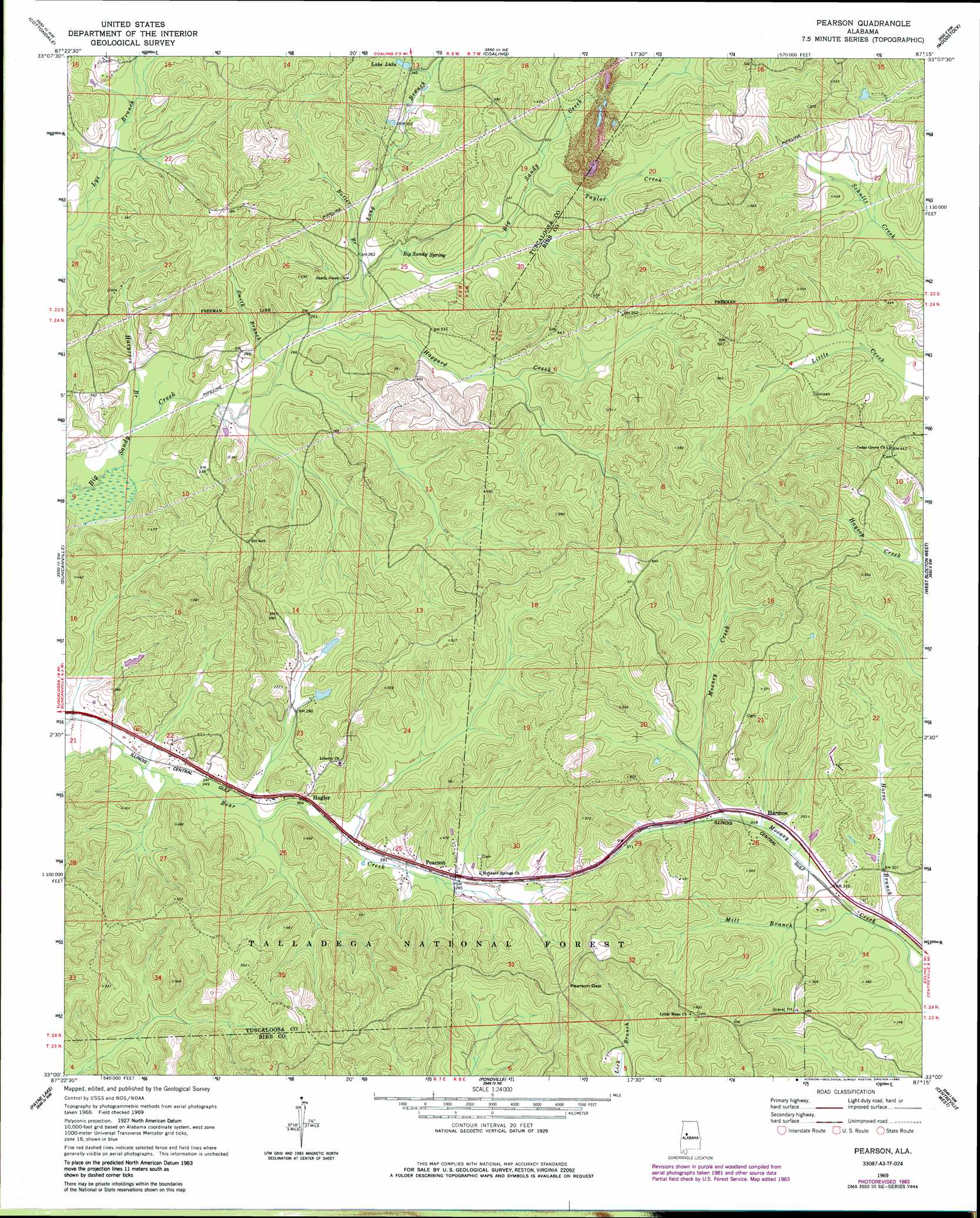
USGS Topo Quad 33087a3 - 1:24,000 scale
| Topo Map Name: | Pearson |
| USGS Topo Quad ID: | 33087a3 |
| Print Size: | ca. 21 1/4" wide x 27" high |
| Southeast Coordinates: | 33° N latitude / 87.25° W longitude |
| Map Center Coordinates: | 33.0625° N latitude / 87.3125° W longitude |
| U.S. State: | AL |
| Filename: | o33087a3.jpg |
| Download Map JPG Image: | Pearson topo map 1:24,000 scale |
| Map Type: | Topographic |
| Topo Series: | 7.5´ |
| Map Scale: | 1:24,000 |
| Source of Map Images: | United States Geological Survey (USGS) |
| Alternate Map Versions: |
Pearson AL 1969, updated 1972 Download PDF Buy paper map Pearson AL 1969, updated 1978 Download PDF Buy paper map Pearson AL 1969, updated 1985 Download PDF Buy paper map Pearson AL 2002, updated 2003 Download PDF Buy paper map Pearson AL 2011 Download PDF Buy paper map Pearson AL 2014 Download PDF Buy paper map |
| FStopo: | US Forest Service topo Pearson is available: Download FStopo PDF Download FStopo TIF |
1:24,000 Topo Quads surrounding Pearson
Lake Tuscaloosa South |
Lake Nicol |
Brookwood |
Abernant |
Mccalla |
Tuscaloosa |
Cottondale |
Coaling |
Woodstock |
Halfmile Shoals |
Englewood |
Duncanville |
Pearson |
West Blocton West |
West Blocton East |
Moundville East |
Payne Lake |
Pondville |
Centreville West |
Centreville East |
Ingram |
Hogglesville |
Heiberger |
Harrisburg |
Oakmulgee |
> Back to 33087a1 at 1:100,000 scale
> Back to 33086a1 at 1:250,000 scale
> Back to U.S. Topo Maps home
Pearson topo map: Gazetteer
Pearson: Gaps
Pearson Gap elevation 161m 528′Pearson: Populated Places
Egypt (historical) elevation 165m 541′Hagler elevation 84m 275′
Harmon elevation 98m 321′
Little Hope elevation 175m 574′
Pearson elevation 93m 305′
Stewart Settlement elevation 132m 433′
Pearson: Reservoirs
Lake Lulu elevation 106m 347′Pearson: Springs
Big Sandy Spring elevation 81m 265′Pearson: Streams
Butler Branch elevation 81m 265′Charley Branch elevation 96m 314′
Haggard Creek elevation 75m 246′
Hargrove Branch elevation 71m 232′
Long Branch elevation 78m 255′
Mill Branch elevation 90m 295′
Muddy Branch elevation 89m 291′
Smith Branch elevation 73m 239′
Taylor Creek elevation 91m 298′
Pearson digital topo map on disk
Buy this Pearson topo map showing relief, roads, GPS coordinates and other geographical features, as a high-resolution digital map file on DVD: