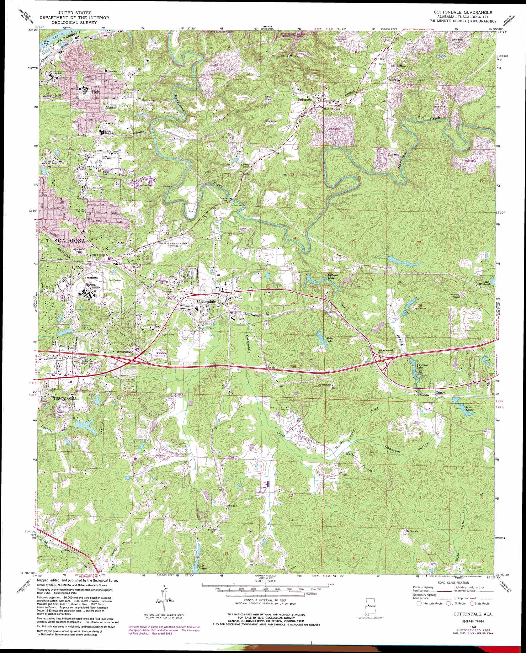
Cottondale Topo Map Alabama
To zoom in, hover over the map of Cottondale
USGS Topo Quad 33087b4 - 1:24,000 scale
| Topo Map Name: | Cottondale |
| USGS Topo Quad ID: | 33087b4 |
| Print Size: | ca. 21 1/4" wide x 27" high |
| Southeast Coordinates: | 33.125° N latitude / 87.375° W longitude |
| Map Center Coordinates: | 33.1875° N latitude / 87.4375° W longitude |
| U.S. State: | AL |
| Filename: | o33087b4.jpg |
| Download Map JPG Image: | Cottondale topo map 1:24,000 scale |
| Map Type: | Topographic |
| Topo Series: | 7.5´ |
| Map Scale: | 1:24,000 |
| Source of Map Images: | United States Geological Survey (USGS) |
| Alternate Map Versions: |
Cottondale AL 1969, updated 1973 Download PDF Buy paper map Cottondale AL 1969, updated 1978 Download PDF Buy paper map Cottondale AL 1969, updated 1983 Download PDF Buy paper map Cottondale AL 2011 Download PDF Buy paper map Cottondale AL 2014 Download PDF Buy paper map |
1:24,000 Topo Quads surrounding Cottondale
Gin Creek |
Lake Tuscaloosa North |
Windham Springs |
Burchfield Store |
Oak Grove |
Lake Lurleen |
Lake Tuscaloosa South |
Lake Nicol |
Brookwood |
Abernant |
Coker |
Tuscaloosa |
Cottondale |
Coaling |
Woodstock |
Fosters |
Englewood |
Duncanville |
Pearson |
West Blocton West |
Moundville West |
Moundville East |
Payne Lake |
Pondville |
Centreville West |
> Back to 33087a1 at 1:100,000 scale
> Back to 33086a1 at 1:250,000 scale
> Back to U.S. Topo Maps home
Cottondale topo map: Gazetteer
Cottondale: Airports
Rainey Field elevation 93m 305′Cottondale: Crossings
Interchange 76 elevation 108m 354′Interchange 79 elevation 99m 324′
Cottondale: Dams
Camp Horne Lake Dam elevation 98m 321′Camp Horne Lake Dam Number 1 elevation 98m 321′
Canyon Lake Dam elevation 73m 239′
Canyon Lake Dam Upper elevation 102m 334′
Canyon Lake Number 2 Dam elevation 105m 344′
East Lake Dam elevation 98m 321′
Echo Lake Dam elevation 95m 311′
Lake Grace Dam elevation 113m 370′
Mallard Lake Dam elevation 89m 291′
Patton Lake Dam elevation 92m 301′
Springhill Lake Dam elevation 101m 331′
Cottondale: Lakes
Echo Lake elevation 95m 311′Lake Grace elevation 113m 370′
Lake Judson elevation 88m 288′
Cottondale: Mines
Creek Pit Mine elevation 113m 370′Fleetwood Mine elevation 123m 403′
Peterson Pit Mine elevation 70m 229′
Cottondale: Parks
Woody Clements Stadium elevation 100m 328′Cottondale: Populated Places
Alpine Hills elevation 116m 380′Altamont elevation 106m 347′
Arcadia elevation 110m 360′
Arrow Wood elevation 111m 364′
Asbury elevation 89m 291′
Austin Subdivision elevation 109m 357′
Banks Villa East elevation 122m 400′
Beech Hills elevation 100m 328′
Berkley Hills elevation 114m 374′
Box Springs elevation 116m 380′
Brentwood elevation 79m 259′
Briarwood elevation 124m 406′
Broadview elevation 135m 442′
Cadillac Estates elevation 97m 318′
Canyon Lakes elevation 98m 321′
Cherrywood elevation 113m 370′
Claymont elevation 99m 324′
Clearview Hills elevation 115m 377′
Clyde Jones Subdivision elevation 109m 357′
Colony Hills elevation 89m 291′
Cottondale elevation 105m 344′
Cottonwood Park elevation 105m 344′
Cresent Heights elevation 104m 341′
Cumberland Park elevation 112m 367′
Deep Wood elevation 70m 229′
Druid Hills elevation 116m 380′
East Lake elevation 110m 360′
East Park elevation 102m 334′
Eastern Hills elevation 117m 383′
Eastover elevation 115m 377′
El Dorado East elevation 111m 364′
Elm Ridge elevation 108m 354′
Fleetwood elevation 122m 400′
Forestasia elevation 111m 364′
Glenwood Park elevation 114m 374′
Golden Acres elevation 107m 351′
Green Grove elevation 81m 265′
Grimes elevation 105m 344′
Hazelhurst elevation 86m 282′
High Point elevation 123m 403′
Hillsdale elevation 99m 324′
Hillswood elevation 123m 403′
Hillview elevation 110m 360′
Holt elevation 116m 380′
Huntland elevation 109m 357′
Hurricane Hills elevation 64m 209′
Judson Park elevation 103m 337′
Keenewood elevation 115m 377′
Kyles Subdivision elevation 87m 285′
Laurel Hills elevation 125m 410′
Lavelle Woods elevation 88m 288′
Lynn Haven elevation 110m 360′
Mayfair elevation 125m 410′
Monte Vista elevation 129m 423′
Nichol Hills elevation 108m 354′
Norris Circle elevation 103m 337′
Norris Estates elevation 103m 337′
Oak Grove elevation 87m 285′
Old Mill Trace elevation 79m 259′
Oxford Gate elevation 131m 429′
Peach Grove elevation 105m 344′
Peterson elevation 127m 416′
Poes Acres elevation 127m 416′
Sherwood Forest elevation 108m 354′
South Holt elevation 111m 364′
South Holt Highlands elevation 119m 390′
Springhill Lake elevation 125m 410′
Standridge elevation 107m 351′
Summerfield elevation 83m 272′
The Staffords elevation 107m 351′
Three Branches Estates elevation 101m 331′
Walker Subdivision elevation 97m 318′
Westview elevation 124m 406′
Whispering Hills elevation 122m 400′
Windsor Drive elevation 98m 321′
Woodland Forest elevation 103m 337′
Woodland Hills elevation 124m 406′
Woodland Park elevation 114m 374′
Woodland Pines elevation 95m 311′
Woodland Terrace elevation 117m 383′
Woodmont elevation 99m 324′
Cottondale: Post Offices
Cottondale Post Office elevation 104m 341′Peterson Post Office elevation 125m 410′
Cottondale: Reservoirs
Camp Horne Lake Number 1 elevation 98m 321′Camp Horne Lake Number 2 elevation 98m 321′
Canyon Lake Lower elevation 73m 239′
Canyon Lake Upper elevation 102m 334′
Dogwood Lake elevation 105m 344′
East Lake elevation 107m 351′
Frierson Lake elevation 88m 288′
Patton Lake elevation 95m 311′
Prudes Mill Pond elevation 97m 318′
Springhill Lake elevation 95m 311′
Woodland Lake elevation 99m 324′
Cottondale: Streams
Bee Branch elevation 57m 187′Cottondale Creek elevation 53m 173′
Goree Coal Bed Branch elevation 64m 209′
Little Flint Branch elevation 81m 265′
Mothers Branch elevation 85m 278′
Ruhama Church Branch elevation 64m 209′
Sniders Spring Branch elevation 72m 236′
Willow Swamp Creek elevation 83m 272′
Cottondale: Valleys
Opossum Hollow elevation 83m 272′Cottondale digital topo map on disk
Buy this Cottondale topo map showing relief, roads, GPS coordinates and other geographical features, as a high-resolution digital map file on DVD: