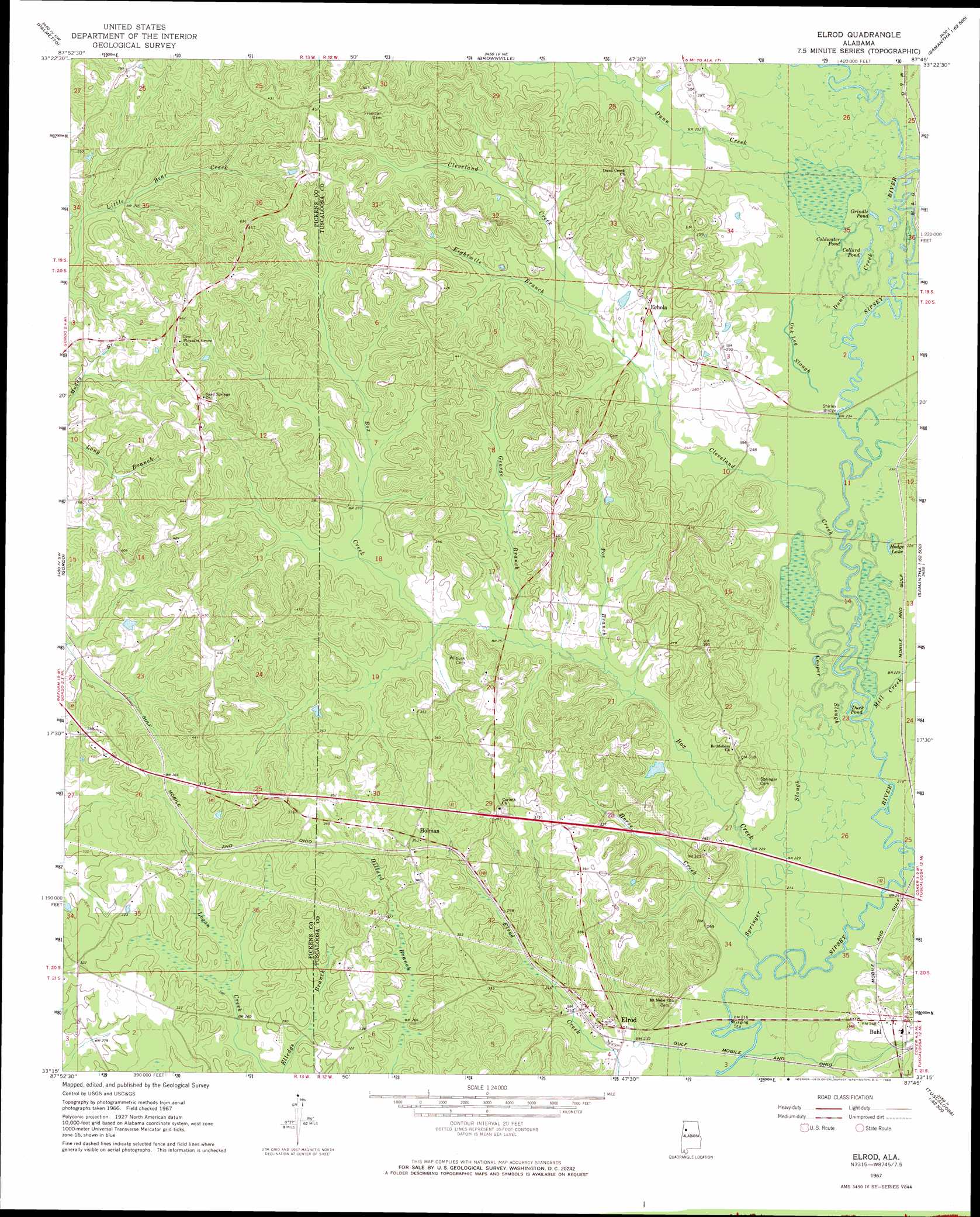
Elrod Topo Map Alabama
To zoom in, hover over the map of Elrod
USGS Topo Quad 33087c7 - 1:24,000 scale
| Topo Map Name: | Elrod |
| USGS Topo Quad ID: | 33087c7 |
| Print Size: | ca. 21 1/4" wide x 27" high |
| Southeast Coordinates: | 33.25° N latitude / 87.75° W longitude |
| Map Center Coordinates: | 33.3125° N latitude / 87.8125° W longitude |
| U.S. State: | AL |
| Filename: | o33087c7.jpg |
| Download Map JPG Image: | Elrod topo map 1:24,000 scale |
| Map Type: | Topographic |
| Topo Series: | 7.5´ |
| Map Scale: | 1:24,000 |
| Source of Map Images: | United States Geological Survey (USGS) |
| Alternate Map Versions: |
Elrod AL 1967, updated 1968 Download PDF Buy paper map Elrod AL 1967, updated 1968 Download PDF Buy paper map Elrod AL 2011 Download PDF Buy paper map Elrod AL 2014 Download PDF Buy paper map |
1:24,000 Topo Quads surrounding Elrod
Millport |
Kennedy |
Newtonville |
New Lexington |
Berry Se |
Reform |
Palmetto |
Brownville |
Gin Creek |
Lake Tuscaloosa North |
Carrollton |
Gordo |
Elrod |
Lake Lurleen |
Lake Tuscaloosa South |
Cunningham |
Kirk |
Romulus |
Coker |
Tuscaloosa |
Pleasant Ridge |
Mantua |
Ralph |
Fosters |
Englewood |
> Back to 33087a1 at 1:100,000 scale
> Back to 33086a1 at 1:250,000 scale
> Back to U.S. Topo Maps home
Elrod topo map: Gazetteer
Elrod: Bridges
Shirley Bridge elevation 70m 229′Elrod: Crossings
Cleveland Ferry (historical) elevation 70m 229′Elrod: Dams
Harless Lake Dam elevation 77m 252′Elrod: Guts
Oak Log Slough elevation 70m 229′Elrod: Lakes
Coldwater Pond elevation 70m 229′Collard Pond elevation 70m 229′
Duck Pond elevation 67m 219′
Grindle Pond elevation 70m 229′
Hodge Lake elevation 68m 223′
Elrod: Populated Places
Buhl elevation 82m 269′Echola elevation 87m 285′
Elrod elevation 75m 246′
Holman elevation 109m 357′
Elrod: Post Offices
Buhl Post Office elevation 83m 272′Echola Post Office elevation 90m 295′
Elrod: Reservoirs
Harless Lake elevation 77m 252′Elrod: Streams
Box Creek elevation 65m 213′Cleveland Creek elevation 67m 219′
Cooper Slough elevation 67m 219′
Dunn Creek elevation 70m 229′
Eightmile Branch elevation 79m 259′
George Branch elevation 77m 252′
Horse Creek elevation 64m 209′
Mud Creek elevation 70m 229′
Poe Branch elevation 71m 232′
Springer Slough elevation 64m 209′
Wards Mill Creek elevation 67m 219′
Elrod digital topo map on disk
Buy this Elrod topo map showing relief, roads, GPS coordinates and other geographical features, as a high-resolution digital map file on DVD: