Lake Tuscaloosa North Topo Map Alabama
To zoom in, hover over the map of Lake Tuscaloosa North
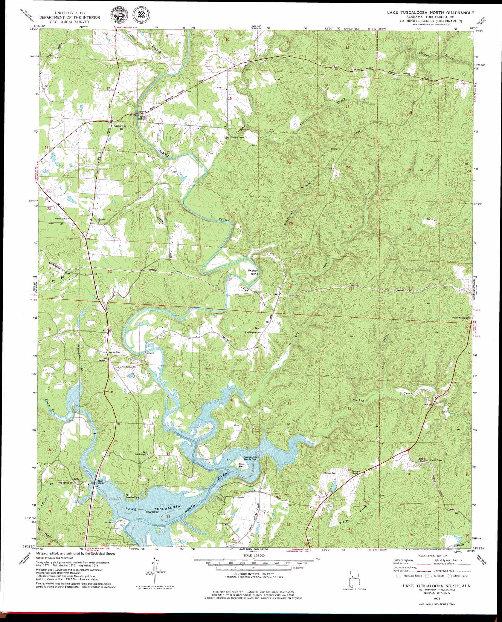
USGS Topo Quad 33087d5 - 1:24,000 scale
| Topo Map Name: | Lake Tuscaloosa North |
| USGS Topo Quad ID: | 33087d5 |
| Print Size: | ca. 21 1/4" wide x 27" high |
| Southeast Coordinates: | 33.375° N latitude / 87.5° W longitude |
| Map Center Coordinates: | 33.4375° N latitude / 87.5625° W longitude |
| U.S. State: | AL |
| Filename: | o33087d5.jpg |
| Download Map JPG Image: | Lake Tuscaloosa North topo map 1:24,000 scale |
| Map Type: | Topographic |
| Topo Series: | 7.5´ |
| Map Scale: | 1:24,000 |
| Source of Map Images: | United States Geological Survey (USGS) |
| Alternate Map Versions: |
Lake Tuscaloosa North AL 1978, updated 1986 Download PDF Buy paper map Lake Tuscaloosa North AL 1978, updated 1986 Download PDF Buy paper map Lake Tuscaloosa North AL 2011 Download PDF Buy paper map Lake Tuscaloosa North AL 2014 Download PDF Buy paper map |
1:24,000 Topo Quads surrounding Lake Tuscaloosa North
Fayette |
Bankston |
Berry |
Oakman |
Parrish |
Newtonville |
New Lexington |
Berry Se |
Wiley |
Tutwiler School |
Brownville |
Gin Creek |
Lake Tuscaloosa North |
Windham Springs |
Burchfield Store |
Elrod |
Lake Lurleen |
Lake Tuscaloosa South |
Lake Nicol |
Brookwood |
Romulus |
Coker |
Tuscaloosa |
Cottondale |
Coaling |
> Back to 33087a1 at 1:100,000 scale
> Back to 33086a1 at 1:250,000 scale
> Back to U.S. Topo Maps home
Lake Tuscaloosa North topo map: Gazetteer
Lake Tuscaloosa North: Bends
Skelton Bend elevation 73m 239′Lake Tuscaloosa North: Dams
Wagon Wheel Lake Dam elevation 121m 396′Lake Tuscaloosa North: Oilfields
Northside Gas Field elevation 105m 344′Lake Tuscaloosa North: Parks
Binion Creek Landing Park elevation 71m 232′Treasure Island County Park elevation 73m 239′
Lake Tuscaloosa North: Populated Places
Binion Heights elevation 81m 265′Hagler Mill Estates elevation 68m 223′
Holiday Shores elevation 95m 311′
North River Shores elevation 81m 265′
North Riviera elevation 92m 301′
Samantha elevation 120m 393′
Searcy Farms elevation 81m 265′
Skelton Bend Estates elevation 87m 285′
Lake Tuscaloosa North: Post Offices
Samantha Post Office elevation 111m 364′Lake Tuscaloosa North: Reservoirs
Wagon Wheel Lake elevation 121m 396′Lake Tuscaloosa North: Springs
Widow Jones Spring elevation 104m 341′Lake Tuscaloosa North: Streams
Binion Creek elevation 68m 223′Cripple Creek elevation 74m 242′
Dry Creek elevation 68m 223′
Gin Branch elevation 81m 265′
Little Creek elevation 94m 308′
Long Creek elevation 75m 246′
Pole Bridge Creek elevation 68m 223′
Thomas Mill Branch elevation 69m 226′
Turkey Creek elevation 68m 223′
Whetstone Branch elevation 94m 308′
Lake Tuscaloosa North digital topo map on disk
Buy this Lake Tuscaloosa North topo map showing relief, roads, GPS coordinates and other geographical features, as a high-resolution digital map file on DVD: