Tutwiler School Topo Map Alabama
To zoom in, hover over the map of Tutwiler School
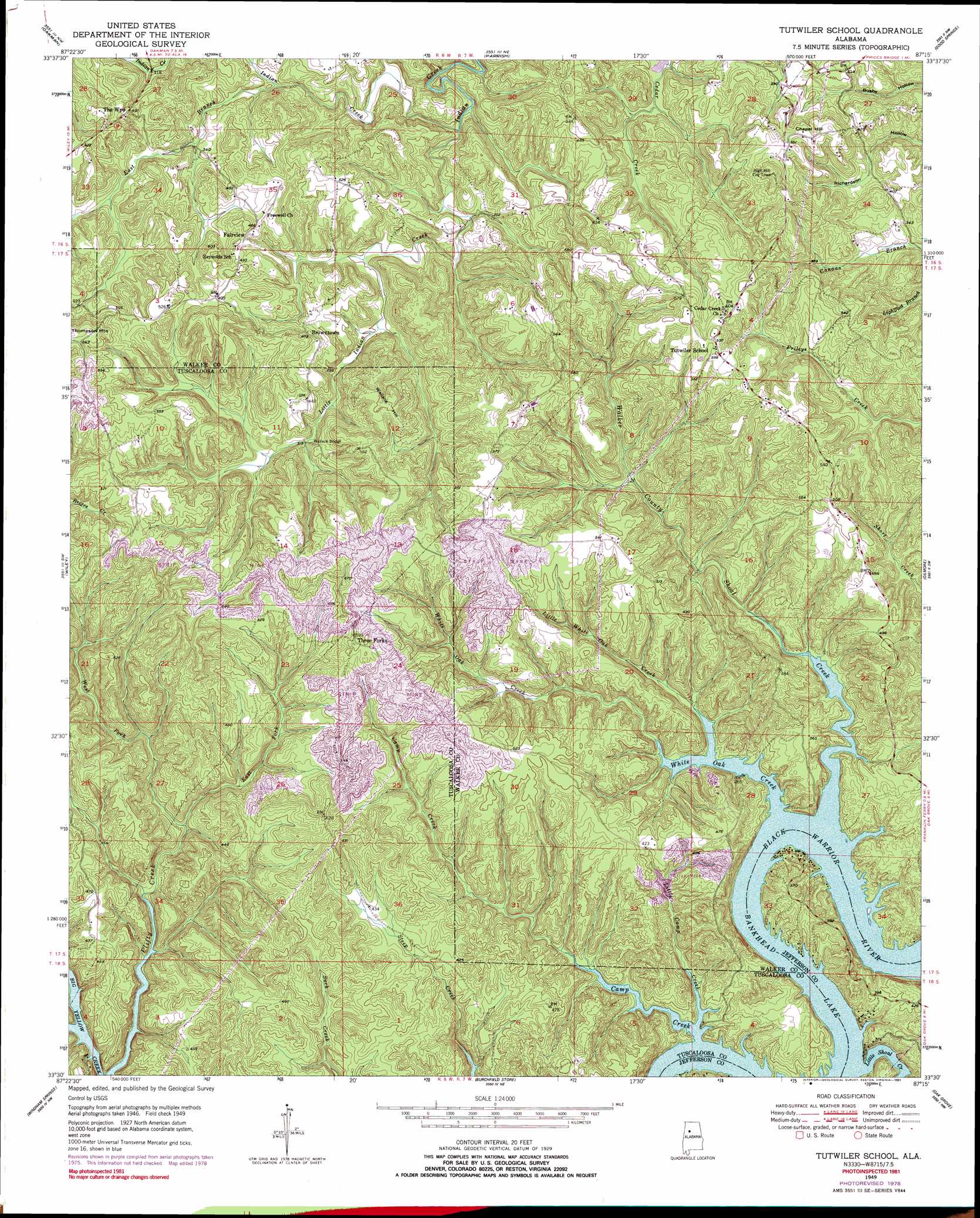
USGS Topo Quad 33087e3 - 1:24,000 scale
| Topo Map Name: | Tutwiler School |
| USGS Topo Quad ID: | 33087e3 |
| Print Size: | ca. 21 1/4" wide x 27" high |
| Southeast Coordinates: | 33.5° N latitude / 87.25° W longitude |
| Map Center Coordinates: | 33.5625° N latitude / 87.3125° W longitude |
| U.S. State: | AL |
| Filename: | o33087e3.jpg |
| Download Map JPG Image: | Tutwiler School topo map 1:24,000 scale |
| Map Type: | Topographic |
| Topo Series: | 7.5´ |
| Map Scale: | 1:24,000 |
| Source of Map Images: | United States Geological Survey (USGS) |
| Alternate Map Versions: |
Tutwiler School AL 1949, updated 1973 Download PDF Buy paper map Tutwiler School AL 1949, updated 1978 Download PDF Buy paper map Tutwiler School AL 1949, updated 1991 Download PDF Buy paper map Tutwiler School AL 1951 Download PDF Buy paper map Tutwiler School AL 1975, updated 1977 Download PDF Buy paper map Tutwiler School AL 2011 Download PDF Buy paper map Tutwiler School AL 2014 Download PDF Buy paper map |
1:24,000 Topo Quads surrounding Tutwiler School
Howard |
Townley |
Jasper |
Cordova |
Sipsey |
Berry |
Oakman |
Parrish |
Goodsprings |
Dora |
Berry Se |
Wiley |
Tutwiler School |
Gilmore |
Sylvan Springs |
Lake Tuscaloosa North |
Windham Springs |
Burchfield Store |
Oak Grove |
Concord |
Lake Tuscaloosa South |
Lake Nicol |
Brookwood |
Abernant |
Mccalla |
> Back to 33087e1 at 1:100,000 scale
> Back to 33086a1 at 1:250,000 scale
> Back to U.S. Topo Maps home
Tutwiler School topo map: Gazetteer
Tutwiler School: Airports
Drummond Airport elevation 76m 249′Tutwiler School: Bars
Black Rock Shoals elevation 76m 249′Tutwiler School: Bends
Heards Bend elevation 79m 259′Humber Bend elevation 88m 288′
Tutwiler School: Bridges
Wallace Bridge elevation 94m 308′Tutwiler School: Dams
Lock Number Twelve (historical) elevation 76m 249′Tutwiler School: Mines
Brown Coal Bed Mine elevation 103m 337′Tutwiler School: Populated Places
Browntown elevation 147m 482′Fairview elevation 150m 492′
Three Forks elevation 186m 610′
Tutwiler elevation 181m 593′
Tutwiler School: Springs
Coal Spring elevation 137m 449′Tutwiler School: Streams
Camp Creek elevation 76m 249′Clifty Creek elevation 78m 255′
East Branch Indian Creek elevation 87m 285′
East Fork Clifty Creek elevation 78m 255′
Little Camp Creek elevation 76m 249′
Little Indian Creek elevation 80m 262′
Little Shoal Creek elevation 76m 249′
Little White Oak Creek elevation 76m 249′
Rocky Branch elevation 87m 285′
Walker County Shoal Creek elevation 76m 249′
West Fork Clifty Creek elevation 97m 318′
White Oak Creek elevation 76m 249′
Wyatt Creek elevation 77m 252′
Tutwiler School: Summits
Chapel Hill elevation 171m 561′Wallace Hill elevation 184m 603′
Tutwiler School digital topo map on disk
Buy this Tutwiler School topo map showing relief, roads, GPS coordinates and other geographical features, as a high-resolution digital map file on DVD: