Oakman Topo Map Alabama
To zoom in, hover over the map of Oakman
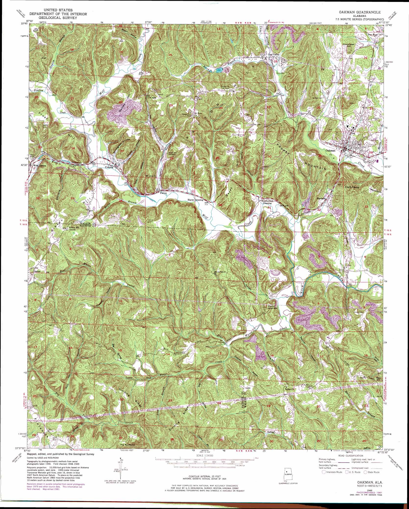
USGS Topo Quad 33087f4 - 1:24,000 scale
| Topo Map Name: | Oakman |
| USGS Topo Quad ID: | 33087f4 |
| Print Size: | ca. 21 1/4" wide x 27" high |
| Southeast Coordinates: | 33.625° N latitude / 87.375° W longitude |
| Map Center Coordinates: | 33.6875° N latitude / 87.4375° W longitude |
| U.S. State: | AL |
| Filename: | o33087f4.jpg |
| Download Map JPG Image: | Oakman topo map 1:24,000 scale |
| Map Type: | Topographic |
| Topo Series: | 7.5´ |
| Map Scale: | 1:24,000 |
| Source of Map Images: | United States Geological Survey (USGS) |
| Alternate Map Versions: |
Oakman AL 1949, updated 1972 Download PDF Buy paper map Oakman AL 1949, updated 1981 Download PDF Buy paper map Oakman AL 1951 Download PDF Buy paper map Oakman AL 2011 Download PDF Buy paper map Oakman AL 2014 Download PDF Buy paper map |
1:24,000 Topo Quads surrounding Oakman
Glen Allen |
Carbon Hill |
Nauvoo |
Manchester |
Sunlight |
Hubbertville |
Howard |
Townley |
Jasper |
Cordova |
Bankston |
Berry |
Oakman |
Parrish |
Goodsprings |
New Lexington |
Berry Se |
Wiley |
Tutwiler School |
Gilmore |
Gin Creek |
Lake Tuscaloosa North |
Windham Springs |
Burchfield Store |
Oak Grove |
> Back to 33087e1 at 1:100,000 scale
> Back to 33086a1 at 1:250,000 scale
> Back to U.S. Topo Maps home
Oakman topo map: Gazetteer
Oakman: Gaps
Low Gap elevation 159m 521′Oakman: Mines
Cave Number 7 Drift Mine elevation 135m 442′Coal Valley Drift Mine elevation 123m 403′
Coal Valley Number 1 Mine elevation 174m 570′
Coal Valley Number 10 Mine elevation 141m 462′
Coal Valley Number 11 Mine elevation 188m 616′
Corona Mine elevation 155m 508′
Corona Number 12 Mine elevation 141m 462′
Corona Number 13 Mine elevation 166m 544′
Corona Number 15 Mine elevation 165m 541′
Days Gap Drift Mine elevation 129m 423′
Deer Creek Mine elevation 164m 538′
Enslen Drift Mine elevation 149m 488′
Frost Drift Mine elevation 152m 498′
Gaslight Mine elevation 177m 580′
Gibson Hill Mine elevation 162m 531′
Marietta Mine elevation 119m 390′
Mary Emma Mine elevation 162m 531′
Mountain Valley Mine elevation 141m 462′
Oakman Mine elevation 122m 400′
Oakman Number 2 Mine elevation 146m 479′
Patton Number 3 Slope Mine elevation 145m 475′
Propst Mountain Mine elevation 209m 685′
Theron Wood Mine elevation 148m 485′
West Corona Mine elevation 124m 406′
Willie Mae Mine elevation 146m 479′
Oakman: Parks
H D Collins Field elevation 111m 364′Oakman: Populated Places
Bethel elevation 184m 603′Coal Valley elevation 112m 367′
Corona elevation 99m 324′
Enoe elevation 97m 318′
Hayes Crossing elevation 96m 314′
Key Hill elevation 186m 610′
Lockhart (historical) elevation 102m 334′
Marietta elevation 115m 377′
Mountain Valley (historical) elevation 135m 442′
Oakman elevation 104m 341′
Patton elevation 99m 324′
Salem elevation 194m 636′
Stephenson Crossing elevation 94m 308′
West Corona elevation 108m 354′
Oakman: Post Offices
Oakman Post Office elevation 104m 341′Oakman: Ridges
Dividing Ridge elevation 192m 629′The Backbone elevation 185m 606′
Oakman: Streams
Bee Spring Branch elevation 126m 413′Black Branch elevation 124m 406′
Blue Water Creek elevation 86m 282′
Dickey Branch elevation 124m 406′
Frost Creek elevation 97m 318′
Jenkins Branch elevation 102m 334′
Lick Branch elevation 109m 357′
Little Blue Water Creek elevation 94m 308′
Pendley Creek elevation 98m 321′
Rocky Branch elevation 94m 308′
Shelton Branch elevation 112m 367′
Oakman: Summits
Biscuit Mountain elevation 135m 442′Clemments Mountain elevation 170m 557′
Cowcumber Hill elevation 172m 564′
Gaines Hill elevation 200m 656′
Gibson Hill elevation 205m 672′
Hayes Hill elevation 176m 577′
Patton Hill elevation 184m 603′
Propst Mountain elevation 205m 672′
Red Hill elevation 172m 564′
Oakman: Valleys
Big Jim Hollow elevation 100m 328′Birmingham Hollow elevation 101m 331′
Brown Hollow elevation 108m 354′
Church Hollow elevation 159m 521′
Coalbed Hollow elevation 115m 377′
Coalbed Hollow elevation 95m 311′
Dipping Vat Hollow elevation 91m 298′
Hamner Hollow elevation 91m 298′
New England Hollow elevation 110m 360′
Patton Hollow elevation 102m 334′
Porter Hollow elevation 106m 347′
Stanford Hollow elevation 104m 341′
Swindle Hollow elevation 89m 291′
Tank Hollow elevation 98m 321′
Wolf Den Hollow elevation 133m 436′
Oakman digital topo map on disk
Buy this Oakman topo map showing relief, roads, GPS coordinates and other geographical features, as a high-resolution digital map file on DVD: