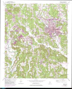
Jasper Topo Map Alabama
To zoom in, hover over the map of Jasper
USGS Topo Quad 33087g3 - 1:24,000 scale
| Topo Map Name: | Jasper |
| USGS Topo Quad ID: | 33087g3 |
| Print Size: | ca. 21 1/4" wide x 27" high |
| Southeast Coordinates: | 33.75° N latitude / 87.25° W longitude |
| Map Center Coordinates: | 33.8125° N latitude / 87.3125° W longitude |
| U.S. State: | AL |
| Filename: | o33087g3.jpg |
| Download Map JPG Image: | Jasper topo map 1:24,000 scale |
| Map Type: | Topographic |
| Topo Series: | 7.5´ |
| Map Scale: | 1:24,000 |
| Source of Map Images: | United States Geological Survey (USGS) |
| Alternate Map Versions: |
Jasper AL 1949, updated 1969 Download PDF Buy paper map Jasper AL 1949, updated 1981 Download PDF Buy paper map Jasper AL 1951 Download PDF Buy paper map Jasper AL 2011 Download PDF Buy paper map Jasper AL 2014 Download PDF Buy paper map |
1:24,000 Topo Quads surrounding Jasper
> Back to 33087e1 at 1:100,000 scale
> Back to 33086a1 at 1:250,000 scale
> Back to U.S. Topo Maps home
Jasper topo map: Gazetteer
Jasper: Airports
Walker County Airport (historical) elevation 148m 485′Jasper: Bridges
McLain Bridge elevation 91m 298′Tubbs Bridge elevation 86m 282′
Jasper: Mines
Bankhead Shaft Mine elevation 151m 495′Calumet Number 2 Slope Mine elevation 166m 544′
Childress Mine elevation 106m 347′
Cunningham Mine elevation 158m 518′
Dark Hollow Drift Mine elevation 181m 593′
Davis Mine elevation 143m 469′
Gamble Mines elevation 154m 505′
Gambrell Mines elevation 151m 495′
Hawes Drift Mine elevation 114m 374′
Hillard Drift Mine elevation 126m 413′
Hillard Mine elevation 138m 452′
McCollum Mine elevation 129m 423′
McCollum Mine elevation 102m 334′
Will-More Mine elevation 142m 465′
Wilson Hill Mine elevation 129m 423′
Jasper: Parks
Carver Park elevation 96m 314′James Fowler Park elevation 108m 354′
Memorial Park elevation 106m 347′
Valley Park elevation 120m 393′
Jasper: Populated Places
Bankhead elevation 127m 416′Calumet elevation 101m 331′
Cameron elevation 101m 331′
Frisco Quarters elevation 96m 314′
Hillsdale elevation 143m 469′
Hudson Mobile Home Park elevation 130m 426′
Jasper elevation 100m 328′
McCollum elevation 133m 436′
New Jagger elevation 121m 396′
Oak Hill elevation 134m 439′
Pleasant Grove elevation 105m 344′
Sardis elevation 149m 488′
Jasper: Post Offices
Jasper Post Office elevation 103m 337′Jasper: Streams
Coke Oven Branch elevation 97m 318′Doctors Branch elevation 97m 318′
Flat Creek elevation 103m 337′
Mooney Branch elevation 108m 354′
Pumpkin Creek elevation 87m 285′
Queen Branch elevation 94m 308′
Rocky Branch elevation 91m 298′
Simmons Branch elevation 86m 282′
Slate Creek elevation 89m 291′
Sparks Branch elevation 98m 321′
Tanyard Creek elevation 91m 298′
Town Creek elevation 88m 288′
Wolf Branch elevation 85m 278′
Jasper: Summits
Academy Hill elevation 135m 442′Bear Pen Mountain elevation 168m 551′
Coke Oven Hill elevation 135m 442′
Crump Hill elevation 123m 403′
Horseshoe Mountain elevation 194m 636′
Kimbrell Hill elevation 181m 593′
Peach Orchard Hill elevation 144m 472′
Stocks Hill elevation 183m 600′
Tubbs Hill elevation 135m 442′
Water Tank Hill elevation 129m 423′
Jasper: Valleys
Dark Hollow elevation 130m 426′Jasper digital topo map on disk
Buy this Jasper topo map showing relief, roads, GPS coordinates and other geographical features, as a high-resolution digital map file on DVD:


