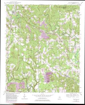
Nauvoo Topo Map Alabama
To zoom in, hover over the map of Nauvoo
USGS Topo Quad 33087h4 - 1:24,000 scale
| Topo Map Name: | Nauvoo |
| USGS Topo Quad ID: | 33087h4 |
| Print Size: | ca. 21 1/4" wide x 27" high |
| Southeast Coordinates: | 33.875° N latitude / 87.375° W longitude |
| Map Center Coordinates: | 33.9375° N latitude / 87.4375° W longitude |
| U.S. State: | AL |
| Filename: | o33087h4.jpg |
| Download Map JPG Image: | Nauvoo topo map 1:24,000 scale |
| Map Type: | Topographic |
| Topo Series: | 7.5´ |
| Map Scale: | 1:24,000 |
| Source of Map Images: | United States Geological Survey (USGS) |
| Alternate Map Versions: |
Nauvoo AL 1949, updated 1973 Download PDF Buy paper map Nauvoo AL 1949, updated 1981 Download PDF Buy paper map Nauvoo AL 1950 Download PDF Buy paper map Nauvoo AL 2000, updated 2003 Download PDF Buy paper map Nauvoo AL 2011 Download PDF Buy paper map Nauvoo AL 2014 Download PDF Buy paper map |
| FStopo: | US Forest Service topo Nauvoo is available: Download FStopo PDF Download FStopo TIF |
1:24,000 Topo Quads surrounding Nauvoo
> Back to 33087e1 at 1:100,000 scale
> Back to 33086a1 at 1:250,000 scale
> Back to U.S. Topo Maps home
Nauvoo topo map: Gazetteer
Nauvoo: Bridges
Buck Creek Bridge elevation 144m 472′Staggs Bridge elevation 144m 472′
Nauvoo: Dams
Odums Mill Dam elevation 153m 501′Nauvoo: Mines
Benson Push Mine elevation 183m 600′Black Creek Mine Number Two elevation 171m 561′
Black Creek Mines elevation 184m 603′
Cedrum Mine elevation 184m 603′
Chickasaw Mine elevation 169m 554′
Deepwater Black Creek Mine elevation 212m 695′
Hill Push Mine elevation 220m 721′
Little Blackwater Mine elevation 193m 633′
Mary Lee Mine elevation 158m 518′
Mary Lee Slope Mine elevation 188m 616′
Nauvoo Number 2 Mine elevation 173m 567′
Pocahontas Mine elevation 183m 600′
Prospect Mines elevation 167m 547′
Rock Slope Mine elevation 178m 583′
Saragosa Mine elevation 185m 606′
Sterling Mine elevation 193m 633′
Tupelo Drift Mine elevation 184m 603′
Nauvoo: Populated Places
Lupton elevation 167m 547′Nauvoo elevation 173m 567′
Prospect elevation 197m 646′
Rosehill elevation 195m 639′
Saragossa elevation 165m 541′
Nauvoo: Post Offices
Nauvoo Post Office elevation 174m 570′Nauvoo: Reservoirs
Odums Mill Pond elevation 153m 501′Nauvoo: Streams
Buck Creek elevation 144m 472′Bunkum Creek elevation 152m 498′
Camp Creek elevation 159m 521′
Cheatham Branch elevation 128m 419′
Cheatham Creek elevation 107m 351′
Dry Branch elevation 144m 472′
Dry Creek elevation 162m 531′
Flat Branch elevation 152m 498′
Gum Fork elevation 148m 485′
Home Creek elevation 146m 479′
Indian Creek elevation 156m 511′
Indian Creek elevation 117m 383′
Leonard Creek elevation 113m 370′
Mill Creek elevation 121m 396′
Panther Branch elevation 149m 488′
Prescott Branch elevation 138m 452′
Sims Branch elevation 135m 442′
Teagle Creek elevation 146m 479′
Wilson Branch elevation 147m 482′
Nauvoo digital topo map on disk
Buy this Nauvoo topo map showing relief, roads, GPS coordinates and other geographical features, as a high-resolution digital map file on DVD:


