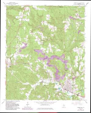
Carbon Hill Topo Map Alabama
To zoom in, hover over the map of Carbon Hill
USGS Topo Quad 33087h5 - 1:24,000 scale
| Topo Map Name: | Carbon Hill |
| USGS Topo Quad ID: | 33087h5 |
| Print Size: | ca. 21 1/4" wide x 27" high |
| Southeast Coordinates: | 33.875° N latitude / 87.5° W longitude |
| Map Center Coordinates: | 33.9375° N latitude / 87.5625° W longitude |
| U.S. State: | AL |
| Filename: | o33087h5.jpg |
| Download Map JPG Image: | Carbon Hill topo map 1:24,000 scale |
| Map Type: | Topographic |
| Topo Series: | 7.5´ |
| Map Scale: | 1:24,000 |
| Source of Map Images: | United States Geological Survey (USGS) |
| Alternate Map Versions: |
Carbon Hill AL 1967, updated 1968 Download PDF Buy paper map Carbon Hill AL 1967, updated 1977 Download PDF Buy paper map Carbon Hill AL 1967, updated 1983 Download PDF Buy paper map Carbon Hill AL 2011 Download PDF Buy paper map Carbon Hill AL 2014 Download PDF Buy paper map |
1:24,000 Topo Quads surrounding Carbon Hill
> Back to 33087e1 at 1:100,000 scale
> Back to 33086a1 at 1:250,000 scale
> Back to U.S. Topo Maps home
Carbon Hill topo map: Gazetteer
Carbon Hill: Dams
Jays Lake Dam elevation 176m 577′Carbon Hill: Mines
Banner Mine elevation 160m 524′Bynum Drift Mine elevation 140m 459′
Carbon Hill Mine elevation 152m 498′
Elk River Shaft Mine elevation 157m 515′
Elliots Mine elevation 132m 433′
Galloway Mine Number Eleven elevation 136m 446′
Galloway Mine Number Six elevation 159m 521′
Galloway Mines elevation 175m 574′
Guthrie Mine elevation 156m 511′
Harris Slope Mine elevation 172m 564′
Hope Mine elevation 211m 692′
Hope-Galloway Mine elevation 189m 620′
Jagger Mine Number Two elevation 195m 639′
Jagger Mines elevation 185m 606′
McGough New Slope Mine elevation 155m 508′
Monroe Mine elevation 178m 583′
Nauvoo Mine elevation 195m 639′
Nauvoo Number 1 Mine elevation 201m 659′
Radiant Mine elevation 172m 564′
Standard Mine elevation 142m 465′
Thornberry Drift Mine elevation 170m 557′
Truck Mine elevation 170m 557′
Wagon Mine elevation 155m 508′
Waldon Mine elevation 191m 626′
Whitson Number 1 Mine elevation 161m 528′
Yateman Mines elevation 159m 521′
Carbon Hill: Oilfields
Eldridge Gas Field elevation 183m 600′Carbon Hill: Populated Places
Carbon Hill elevation 146m 479′Clarke elevation 152m 498′
Dogtown elevation 182m 597′
Eldridge elevation 169m 554′
Flatwood elevation 180m 590′
Kansas elevation 140m 459′
Slicklizzard elevation 187m 613′
Spring Hill elevation 201m 659′
Carbon Hill: Reservoirs
Jays Lake elevation 176m 577′Carbon Hill: Streams
Allen Creek elevation 124m 406′Camp Spring Branch elevation 149m 488′
Clifty Branch elevation 121m 396′
Cranford Creek elevation 122m 400′
Gilder Creek elevation 133m 436′
Old Glady Branch elevation 162m 531′
Rabbit Branch elevation 122m 400′
Trinity Creek elevation 130m 426′
Turkey Creek elevation 128m 419′
Carbon Hill: Summits
Seamore Mountain elevation 239m 784′Sleepy Mountain elevation 192m 629′
Carbon Hill digital topo map on disk
Buy this Carbon Hill topo map showing relief, roads, GPS coordinates and other geographical features, as a high-resolution digital map file on DVD:


