West Point Topo Map Mississippi
To zoom in, hover over the map of West Point
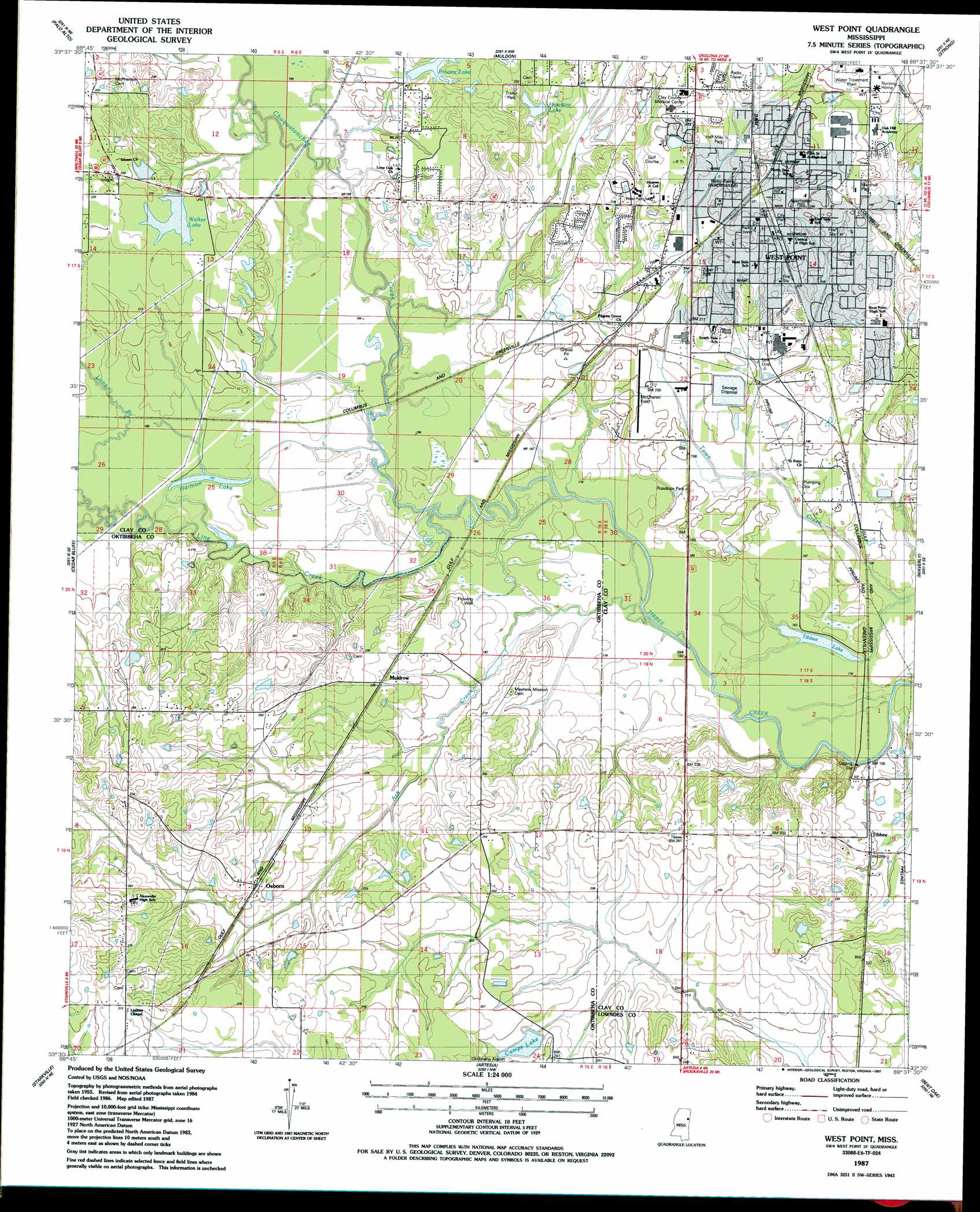
USGS Topo Quad 33088e6 - 1:24,000 scale
| Topo Map Name: | West Point |
| USGS Topo Quad ID: | 33088e6 |
| Print Size: | ca. 21 1/4" wide x 27" high |
| Southeast Coordinates: | 33.5° N latitude / 88.625° W longitude |
| Map Center Coordinates: | 33.5625° N latitude / 88.6875° W longitude |
| U.S. State: | MS |
| Filename: | o33088e6.jpg |
| Download Map JPG Image: | West Point topo map 1:24,000 scale |
| Map Type: | Topographic |
| Topo Series: | 7.5´ |
| Map Scale: | 1:24,000 |
| Source of Map Images: | United States Geological Survey (USGS) |
| Alternate Map Versions: |
West Point MS 1987, updated 1987 Download PDF Buy paper map West Point MS 2012 Download PDF Buy paper map West Point MS 2015 Download PDF Buy paper map |
1:24,000 Topo Quads surrounding West Point
Sparta |
Trebloc |
Prairie |
Aberdeen |
Amory Sw |
Montpelier |
Palo Alto |
Muldon |
Strong |
Hamilton |
Pheba |
Cedar Bluff |
West Point |
Waverly |
Columbus North |
Longview |
Starkville |
Artesia |
Bent Oak |
Columbus South |
Bradley |
Bluff Lake |
Crawford West |
Crawford East |
Trinity |
> Back to 33088e1 at 1:100,000 scale
> Back to 33088a1 at 1:250,000 scale
> Back to U.S. Topo Maps home
West Point topo map: Gazetteer
West Point: Airports
McCharen Field elevation 60m 196′West Point: Cliffs
Lyons Bluff elevation 62m 203′West Point: Crossings
Dicks Ferry (historical) elevation 51m 167′West Point: Dams
Camps Lake Dam elevation 73m 239′Crumpton Lake Dam elevation 73m 239′
Hawkins Lake Dam elevation 67m 219′
Johnson Lake Dam elevation 63m 206′
Love Lake Dam elevation 70m 229′
Love Lake Dam elevation 77m 252′
Mississippi No Name 152 Dam elevation 62m 203′
Proctor Lake Dam elevation 64m 209′
Starkville Gun Club Lake Dam elevation 95m 311′
Walker Lake Dam elevation 64m 209′
West Point Sewage Lagoon Dam elevation 61m 200′
Wilkie Lake Dam elevation 64m 209′
West Point: Lakes
Harmon Lake elevation 54m 177′Tibbee Lake elevation 52m 170′
West Point: Parks
Bruce Field elevation 77m 252′Chuck Keys Field elevation 76m 249′
Half Mile Park elevation 70m 229′
Marshall Park elevation 78m 255′
Sportsman Park elevation 74m 242′
Stumpy Wood Field elevation 77m 252′
West Point City Park elevation 73m 239′
Zuber Park elevation 65m 213′
West Point: Populated Places
Muldrow elevation 70m 229′Osborn elevation 80m 262′
Tibbee elevation 62m 203′
West Point elevation 71m 232′
West Point: Post Offices
West Point Post Office elevation 73m 239′West Point: Reservoirs
Camps Lake elevation 73m 239′Hawkins Lake elevation 67m 219′
Lake Wooten elevation 75m 246′
Proctor Lake elevation 64m 209′
Walker Lake elevation 63m 206′
West Point: Streams
Ash Creek elevation 52m 170′Chuquatonchee Creek elevation 52m 170′
Line Creek elevation 52m 170′
Long Branch elevation 55m 180′
West Point digital topo map on disk
Buy this West Point topo map showing relief, roads, GPS coordinates and other geographical features, as a high-resolution digital map file on DVD: