Eupora Topo Map Mississippi
To zoom in, hover over the map of Eupora
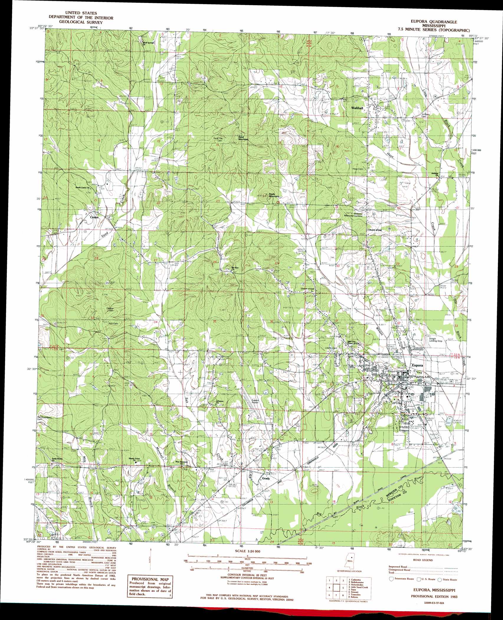
USGS Topo Quad 33089e3 - 1:24,000 scale
| Topo Map Name: | Eupora |
| USGS Topo Quad ID: | 33089e3 |
| Print Size: | ca. 21 1/4" wide x 27" high |
| Southeast Coordinates: | 33.5° N latitude / 89.25° W longitude |
| Map Center Coordinates: | 33.5625° N latitude / 89.3125° W longitude |
| U.S. State: | MS |
| Filename: | o33089e3.jpg |
| Download Map JPG Image: | Eupora topo map 1:24,000 scale |
| Map Type: | Topographic |
| Topo Series: | 7.5´ |
| Map Scale: | 1:24,000 |
| Source of Map Images: | United States Geological Survey (USGS) |
| Alternate Map Versions: |
Walthall SE MS 1976, updated 1977 Download PDF Buy paper map Eupora MS 1983, updated 1984 Download PDF Buy paper map Eupora MS 1983, updated 1984 Download PDF Buy paper map Eupora MS 2012 Download PDF Buy paper map Eupora MS 2015 Download PDF Buy paper map |
1:24,000 Topo Quads surrounding Eupora
Gore Springs |
Big Creek |
Calhoun City |
Atlanta |
Woodland |
Sweatman |
Cadaretta |
Bellefontaine |
Hohenlinden |
Mantee |
Lodi |
Little Sand Creek |
Eupora |
Sapa |
Maben |
Kilmichael |
Stewart |
Tomnolen |
Reform |
Double Springs |
Poplar Creek |
French Camp |
Weir |
Ackerman |
Sturgis |
> Back to 33089e1 at 1:100,000 scale
> Back to 33088a1 at 1:250,000 scale
> Back to U.S. Topo Maps home
Eupora topo map: Gazetteer
Eupora: Airports
Eupora Airport elevation 129m 423′Eupora: Dams
Doss Lake Dam elevation 115m 377′Russell Lake Dam elevation 135m 442′
Eupora: Populated Places
Center elevation 121m 396′Eupora elevation 117m 383′
Gibson elevation 130m 426′
Grady elevation 108m 354′
Magnolia Heights elevation 116m 380′
Pine Hill Estates elevation 129m 423′
Shady Grove elevation 133m 436′
Southland Park elevation 119m 390′
Walthall elevation 140m 459′
Westwood elevation 130m 426′
Whites Creek East elevation 122m 400′
Whites Creek West elevation 128m 419′
Eupora: Streams
Hays Creek elevation 114m 374′Little Black Creek elevation 106m 347′
Whites Creek elevation 110m 360′
Eupora: Summits
Church Hill elevation 147m 482′Rocky Mountain elevation 183m 600′
Sand Mountain elevation 200m 656′
Eupora digital topo map on disk
Buy this Eupora topo map showing relief, roads, GPS coordinates and other geographical features, as a high-resolution digital map file on DVD: