Shelby Topo Map Mississippi
To zoom in, hover over the map of Shelby
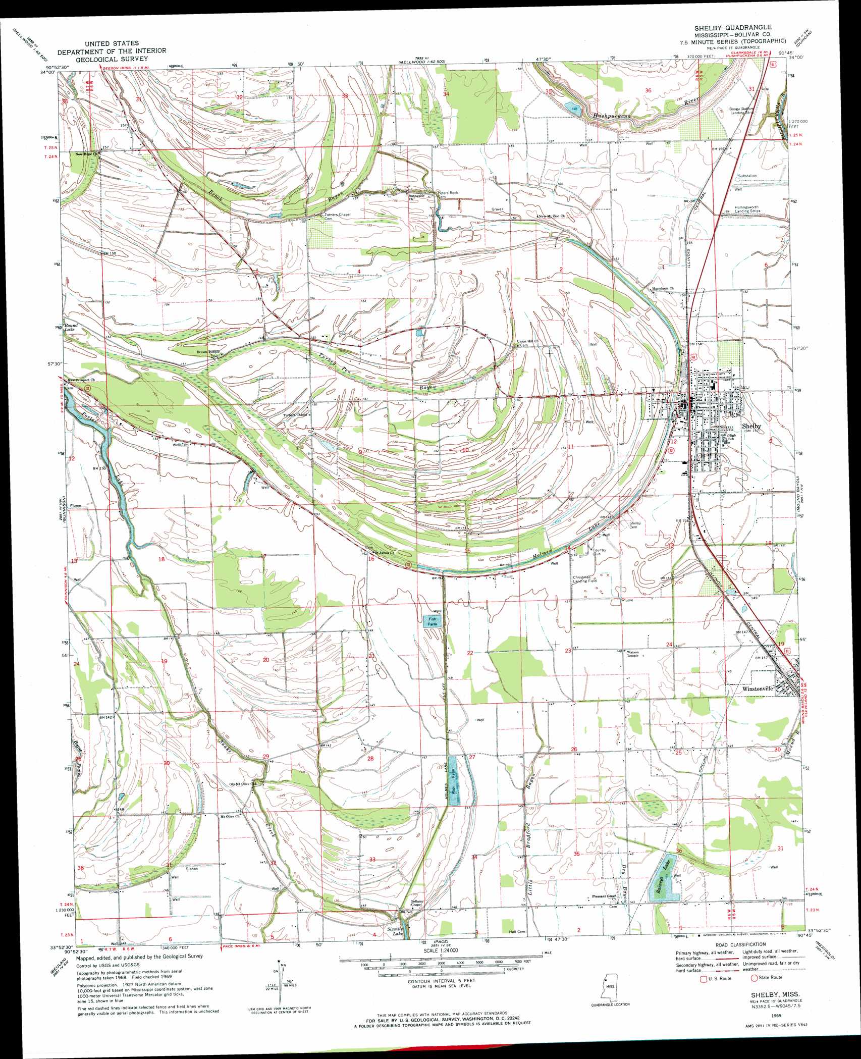
USGS Topo Quad 33090h7 - 1:24,000 scale
| Topo Map Name: | Shelby |
| USGS Topo Quad ID: | 33090h7 |
| Print Size: | ca. 21 1/4" wide x 27" high |
| Southeast Coordinates: | 33.875° N latitude / 90.75° W longitude |
| Map Center Coordinates: | 33.9375° N latitude / 90.8125° W longitude |
| U.S. State: | MS |
| Filename: | o33090h7.jpg |
| Download Map JPG Image: | Shelby topo map 1:24,000 scale |
| Map Type: | Topographic |
| Topo Series: | 7.5´ |
| Map Scale: | 1:24,000 |
| Source of Map Images: | United States Geological Survey (USGS) |
| Alternate Map Versions: |
Shelby MS 1969, updated 1971 Download PDF Buy paper map Shelby MS 2012 Download PDF Buy paper map Shelby MS 2015 Download PDF Buy paper map |
1:24,000 Topo Quads surrounding Shelby
Henrico Ne |
Mellwood |
Rena Lara |
Sherard |
Clarksdale |
Snow Lake |
Laconia |
Round Lake |
Duncan |
Mattson |
Montgomery Island |
Gunnison |
Shelby |
Mound Bayou |
Baltzer |
Rosedale |
Beulah |
Pace |
Merigold |
Drew |
Benoit |
Lobdell |
Skene |
Cleveland |
Ruleville |
> Back to 33090e1 at 1:100,000 scale
> Back to 33090a1 at 1:250,000 scale
> Back to U.S. Topo Maps home
Shelby topo map: Gazetteer
Shelby: Airports
Christmas Airport elevation 46m 150′Shelby: Canals
Ditch Number Five elevation 43m 141′Ditch Number Four elevation 44m 144′
Ditch Number One elevation 44m 144′
Ditch Number Six elevation 43m 141′
Ditch Number Three elevation 42m 137′
Holmes Lake Cut-Off elevation 43m 141′
Shelby: Dams
Allendales Lake Dam elevation 38m 124′Mound Bayou Recreation Lake Dam elevation 44m 144′
Shelby: Guts
Turkey Pen Bayou elevation 43m 141′Shelby: Lakes
Holmes Lake elevation 42m 137′Porter Lake elevation 41m 134′
Raineys Lake elevation 42m 137′
Shelby: Populated Places
Shelby elevation 47m 154′Winstonville elevation 45m 147′
Shelby: Streams
Upper Bogue elevation 44m 144′Shelby: Swamps
California Brake (historical) elevation 43m 141′Shelby digital topo map on disk
Buy this Shelby topo map showing relief, roads, GPS coordinates and other geographical features, as a high-resolution digital map file on DVD: