Macon Lake Topo Map Arkansas
To zoom in, hover over the map of Macon Lake
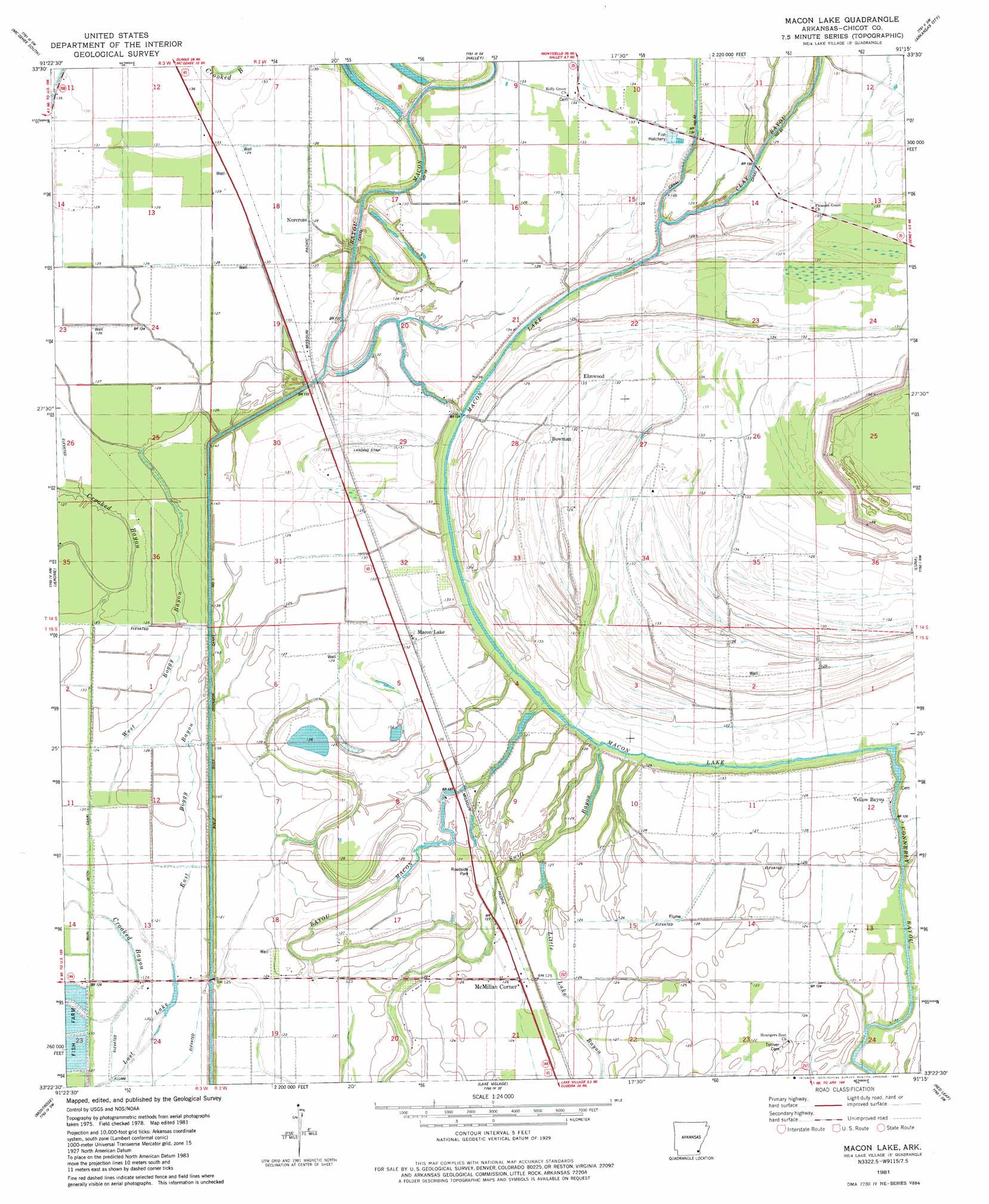
USGS Topo Quad 33091d3 - 1:24,000 scale
| Topo Map Name: | Macon Lake |
| USGS Topo Quad ID: | 33091d3 |
| Print Size: | ca. 21 1/4" wide x 27" high |
| Southeast Coordinates: | 33.375° N latitude / 91.25° W longitude |
| Map Center Coordinates: | 33.4375° N latitude / 91.3125° W longitude |
| U.S. State: | AR |
| Filename: | o33091d3.jpg |
| Download Map JPG Image: | Macon Lake topo map 1:24,000 scale |
| Map Type: | Topographic |
| Topo Series: | 7.5´ |
| Map Scale: | 1:24,000 |
| Source of Map Images: | United States Geological Survey (USGS) |
| Alternate Map Versions: |
Lake Village NE AR 1975, updated 1976 Download PDF Buy paper map Macon Lake AR 1981, updated 1982 Download PDF Buy paper map Macon Lake AR 2011 Download PDF Buy paper map Macon Lake AR 2014 Download PDF Buy paper map |
1:24,000 Topo Quads surrounding Macon Lake
Selma |
Mcgehee North |
Mcarthur |
Catfish Point |
Benoit |
Collins |
Mcgehee South |
Halley |
Arkansas City |
Scott |
Line |
Jerome |
Macon Lake |
Luna |
Greenville |
Snyder |
Montrose |
Lake Village |
Red Leaf |
Wayside |
Portland |
Eudora Nw |
Eudora North |
Eminence |
Avon |
> Back to 33091a1 at 1:100,000 scale
> Back to 33090a1 at 1:250,000 scale
> Back to U.S. Topo Maps home
Macon Lake topo map: Gazetteer
Macon Lake: Canals
Diversion Canal Number 1 elevation 36m 118′Macon Lake: Dams
Connerly Bayou Pumping Station Dam elevation 34m 111′Macon Lake: Guts
Connerly Bayou elevation 38m 124′Swift Bayou elevation 40m 131′
Macon Lake: Lakes
Duck Lake elevation 39m 127′Macon Lake elevation 32m 104′
Macon Lake: Populated Places
Bowman elevation 39m 127′Elmwood elevation 38m 124′
Kaplin (historical) elevation 39m 127′
Macon Lake elevation 39m 127′
Maxey (historical) elevation 38m 124′
McMillan Corner elevation 39m 127′
Yellow Bayou elevation 39m 127′
Macon Lake: Streams
East Boggy Bayou elevation 37m 121′West Boggy Bayou elevation 37m 121′
Macon Lake digital topo map on disk
Buy this Macon Lake topo map showing relief, roads, GPS coordinates and other geographical features, as a high-resolution digital map file on DVD: