Snow Hill Topo Map Arkansas
To zoom in, hover over the map of Snow Hill
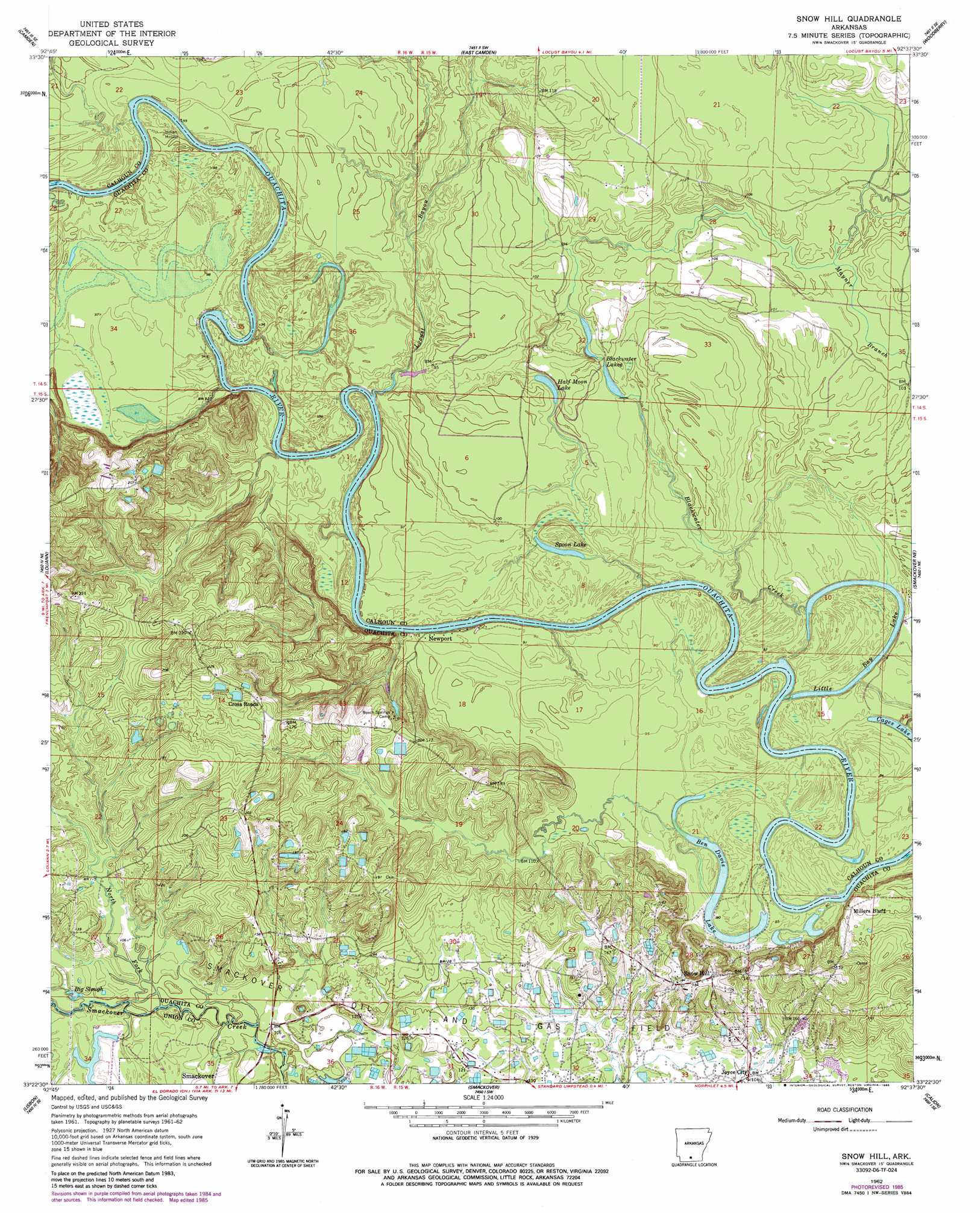
USGS Topo Quad 33092d6 - 1:24,000 scale
| Topo Map Name: | Snow Hill |
| USGS Topo Quad ID: | 33092d6 |
| Print Size: | ca. 21 1/4" wide x 27" high |
| Southeast Coordinates: | 33.375° N latitude / 92.625° W longitude |
| Map Center Coordinates: | 33.4375° N latitude / 92.6875° W longitude |
| U.S. State: | AR |
| Filename: | o33092d6.jpg |
| Download Map JPG Image: | Snow Hill topo map 1:24,000 scale |
| Map Type: | Topographic |
| Topo Series: | 7.5´ |
| Map Scale: | 1:24,000 |
| Source of Map Images: | United States Geological Survey (USGS) |
| Alternate Map Versions: |
Snow Hill AR 1962, updated 1963 Download PDF Buy paper map Snow Hill AR 1962, updated 1971 Download PDF Buy paper map Snow Hill AR 1962, updated 1986 Download PDF Buy paper map Snow Hill AR 2011 Download PDF Buy paper map Snow Hill AR 2014 Download PDF Buy paper map |
1:24,000 Topo Quads surrounding Snow Hill
Bragg City |
Harmony Grove |
Eagle Mills |
Bearden |
Chambersville |
Camden Sw |
Camden |
East Camden |
Woodberry |
Hampton |
Buena Vista |
Louann |
Snow Hill |
Smackover Ne |
Artesian |
Mount Holly |
Lisbon |
Smackover |
Calion |
Harrell Brake |
Marysville |
Newell |
El Dorado West |
El Dorado East |
Urbana |
> Back to 33092a1 at 1:100,000 scale
> Back to 33092a1 at 1:250,000 scale
> Back to U.S. Topo Maps home
Snow Hill topo map: Gazetteer
Snow Hill: Bars
Blue Beach Shoals elevation 25m 82′Cold Bite Shoal elevation 25m 82′
English Bee Shoal elevation 25m 82′
Hog Eye Shoal elevation 26m 85′
Newport Shoals elevation 23m 75′
Spoon Camp Shoals elevation 25m 82′
Snow Hill: Guts
Big Slough elevation 31m 101′Snow Hill: Lakes
Ben Davis Lake elevation 24m 78′Blackwater Lakes elevation 28m 91′
Cages Lake elevation 25m 82′
Half Moon Lake elevation 28m 91′
Little Bay Lake elevation 26m 85′
Spoon Lake elevation 26m 85′
Snow Hill: Oilfields
Smackover Oil and Gas Field elevation 40m 131′Snow Hill: Populated Places
Cross Roads elevation 54m 177′Joyce City elevation 32m 104′
Little Bay (historical) elevation 30m 98′
Millers Bluff elevation 39m 127′
Newport elevation 26m 85′
Snow Hill elevation 56m 183′
Snow Hill: Streams
Blackwater Creek elevation 27m 88′Hill Slough elevation 25m 82′
Locust Bayou elevation 26m 85′
North Fork Smackover Creek elevation 34m 111′
Snow Hill digital topo map on disk
Buy this Snow Hill topo map showing relief, roads, GPS coordinates and other geographical features, as a high-resolution digital map file on DVD: