Doddridge Se Topo Map Arkansas
To zoom in, hover over the map of Doddridge Se
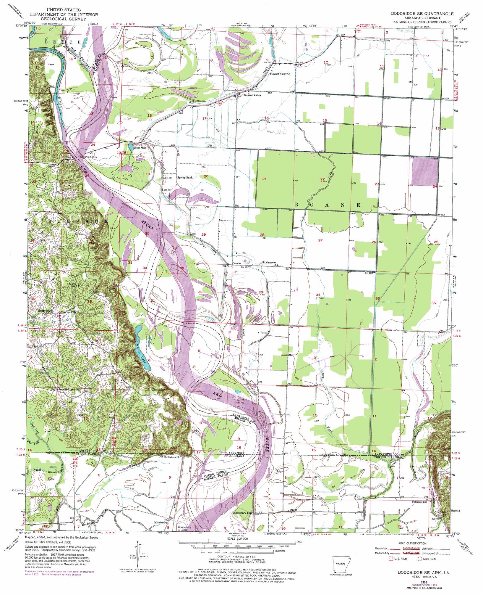
USGS Topo Quad 33093a7 - 1:24,000 scale
| Topo Map Name: | Doddridge Se |
| USGS Topo Quad ID: | 33093a7 |
| Print Size: | ca. 21 1/4" wide x 27" high |
| Southeast Coordinates: | 33° N latitude / 93.75° W longitude |
| Map Center Coordinates: | 33.0625° N latitude / 93.8125° W longitude |
| U.S. States: | AR, LA |
| Filename: | o33093a7.jpg |
| Download Map JPG Image: | Doddridge Se topo map 1:24,000 scale |
| Map Type: | Topographic |
| Topo Series: | 7.5´ |
| Map Scale: | 1:24,000 |
| Source of Map Images: | United States Geological Survey (USGS) |
| Alternate Map Versions: |
Doddridge SE AR 1952, updated 1953 Download PDF Buy paper map Doddridge SE AR 1952, updated 1973 Download PDF Buy paper map Doddridge SE AR 1952, updated 1976 Download PDF Buy paper map Doddridge SE AR 2011 Download PDF Buy paper map Doddridge SE AR 2014 Download PDF Buy paper map |
1:24,000 Topo Quads surrounding Doddridge Se
Domino |
Fouke |
Fouke Se |
Garland |
Lewisville |
Bloomburg |
Doddridge Nw |
Doddridge Ne |
Canfield |
Bradley Ne |
Ravanna |
Doddridge |
Doddridge Se |
Bradley |
Bradley Se |
Mcleod |
Vivian North |
Wardview |
Plain Dealing |
Carterville |
Trees |
Vivian South |
Gilliam |
Hughes |
Ivan |
> Back to 33093a1 at 1:100,000 scale
> Back to 33092a1 at 1:250,000 scale
> Back to U.S. Topo Maps home
Doddridge Se topo map: Gazetteer
Doddridge Se: Flats
Old Bed Rotten Lake elevation 59m 193′Doddridge Se: Lakes
Blue Hole elevation 61m 200′Palmer Lake elevation 60m 196′
Doddridge Se: Oilfields
Kiblah Oil and Gas Field elevation 61m 200′Doddridge Se: Populated Places
Canale elevation 61m 200′Missionary elevation 63m 206′
Pleasant Valley elevation 63m 206′
Smithville elevation 72m 236′
Spring Bank (historical) elevation 101m 331′
Doddridge Se: Streams
Bardstown Bayou elevation 60m 196′Dry Fork elevation 57m 187′
Dry Fork elevation 61m 200′
East Fork Kelly Bayou elevation 59m 193′
Nance Branch elevation 59m 193′
Old Channel McKinney Bayou elevation 59m 193′
Posten Bayou elevation 59m 193′
Stillhouse Bayou elevation 59m 193′
Sulphur River elevation 56m 183′
West Fork Kelly Bayou elevation 58m 190′
Doddridge Se digital topo map on disk
Buy this Doddridge Se topo map showing relief, roads, GPS coordinates and other geographical features, as a high-resolution digital map file on DVD: