Bloomburg Topo Map Texas
To zoom in, hover over the map of Bloomburg
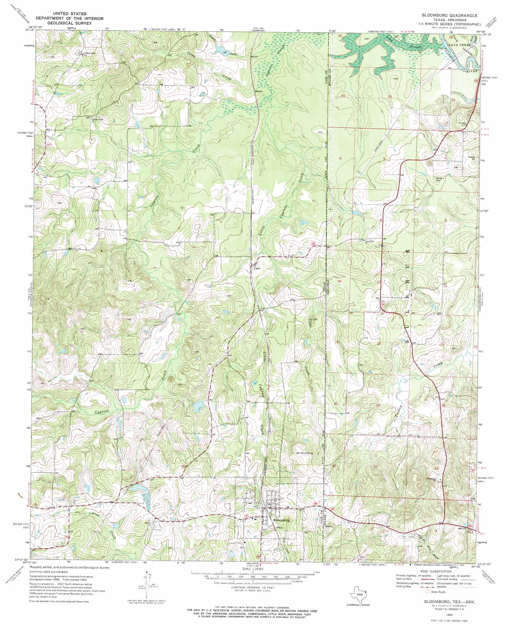
USGS Topo Quad 33094b1 - 1:24,000 scale
| Topo Map Name: | Bloomburg |
| USGS Topo Quad ID: | 33094b1 |
| Print Size: | ca. 21 1/4" wide x 27" high |
| Southeast Coordinates: | 33.125° N latitude / 94° W longitude |
| Map Center Coordinates: | 33.1875° N latitude / 94.0625° W longitude |
| U.S. States: | TX, AR |
| Filename: | o33094b1.jpg |
| Download Map JPG Image: | Bloomburg topo map 1:24,000 scale |
| Map Type: | Topographic |
| Topo Series: | 7.5´ |
| Map Scale: | 1:24,000 |
| Source of Map Images: | United States Geological Survey (USGS) |
| Alternate Map Versions: |
Bloomburg TX 1969, updated 1972 Download PDF Buy paper map Bloomburg TX 2011 Download PDF Buy paper map Bloomburg TX 2013 Download PDF Buy paper map Bloomburg TX 2016 Download PDF Buy paper map |
1:24,000 Topo Quads surrounding Bloomburg
Hooks |
Leary |
Texarkana |
Mandeville |
Fouke Ne |
Maud |
Wright Patman Dam |
Domino |
Fouke |
Fouke Se |
Douglassville |
Atlanta North |
Bloomburg |
Doddridge Nw |
Doddridge Ne |
Linden |
Atlanta South |
Ravanna |
Doddridge |
Doddridge Se |
Lanier |
Kildare |
Mcleod |
Vivian North |
Wardview |
> Back to 33094a1 at 1:100,000 scale
> Back to 33094a1 at 1:250,000 scale
> Back to U.S. Topo Maps home
Bloomburg topo map: Gazetteer
Bloomburg: Dams
Alex Smith Lake Dam elevation 63m 206′International Paper Company Dam elevation 68m 223′
Long Slough Dam elevation 63m 206′
Porterfield Lake Dam elevation 77m 252′
Bloomburg: Lakes
Long Slough elevation 61m 200′Bloomburg: Populated Places
Bloomburg elevation 96m 314′Cass elevation 73m 239′
Bloomburg: Reservoirs
Porterfield Lake elevation 77m 252′Smith Lake elevation 63m 206′
Supervisors Club Pond elevation 68m 223′
Bloomburg: Streams
Camp Creek elevation 63m 206′Cypress Creek elevation 63m 206′
Grassy Creek elevation 64m 209′
Little Cypress Creek elevation 63m 206′
Texas Creek elevation 66m 216′
Bloomburg digital topo map on disk
Buy this Bloomburg topo map showing relief, roads, GPS coordinates and other geographical features, as a high-resolution digital map file on DVD: