Dalby Springs Topo Map Texas
To zoom in, hover over the map of Dalby Springs
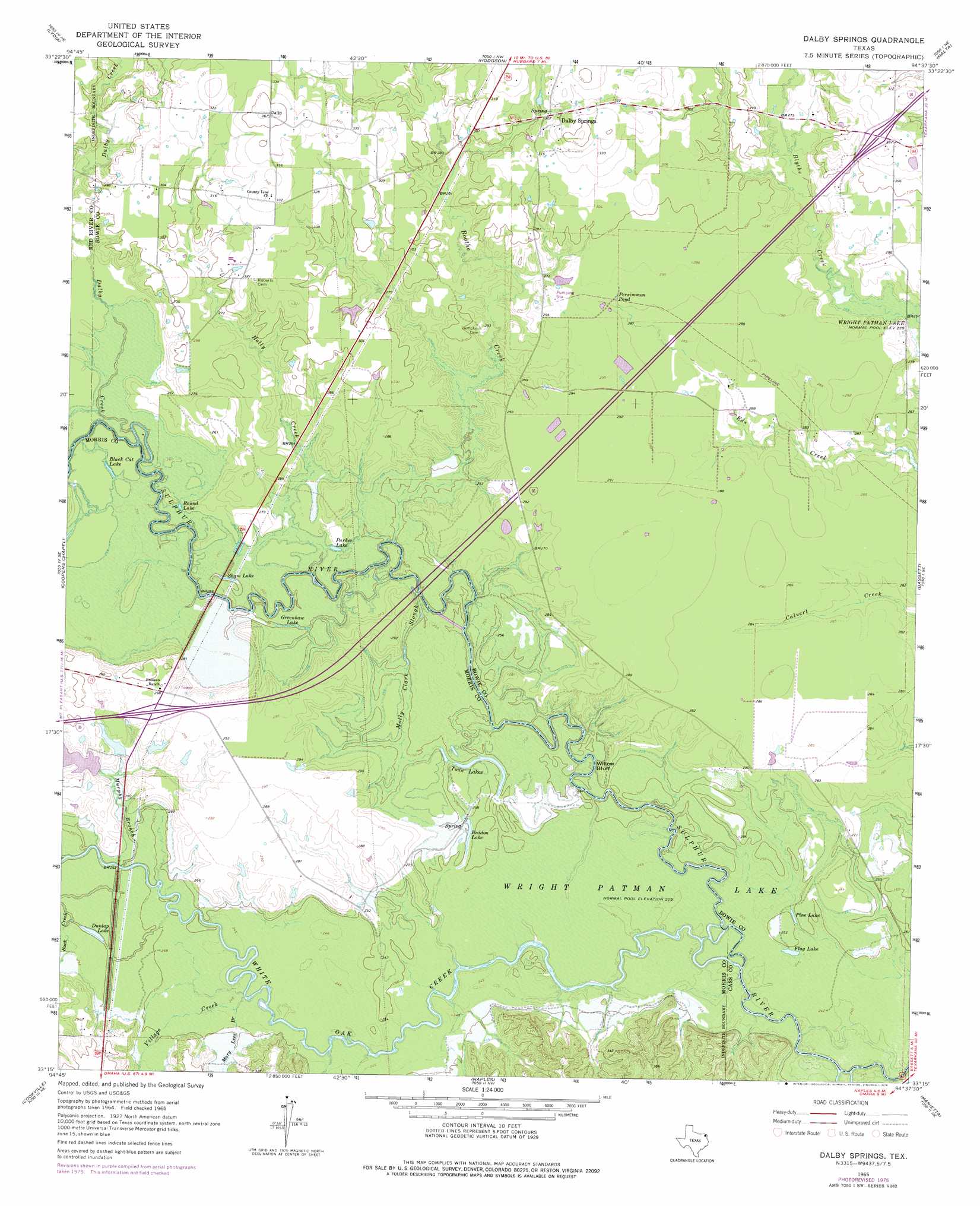
USGS Topo Quad 33094c6 - 1:24,000 scale
| Topo Map Name: | Dalby Springs |
| USGS Topo Quad ID: | 33094c6 |
| Print Size: | ca. 21 1/4" wide x 27" high |
| Southeast Coordinates: | 33.25° N latitude / 94.625° W longitude |
| Map Center Coordinates: | 33.3125° N latitude / 94.6875° W longitude |
| U.S. State: | TX |
| Filename: | o33094c6.jpg |
| Download Map JPG Image: | Dalby Springs topo map 1:24,000 scale |
| Map Type: | Topographic |
| Topo Series: | 7.5´ |
| Map Scale: | 1:24,000 |
| Source of Map Images: | United States Geological Survey (USGS) |
| Alternate Map Versions: |
Dalby Springs TX 1965, updated 1967 Download PDF Buy paper map Dalby Springs TX 1965, updated 1976 Download PDF Buy paper map Dalby Springs TX 2010 Download PDF Buy paper map Dalby Springs TX 2013 Download PDF Buy paper map Dalby Springs TX 2016 Download PDF Buy paper map |
1:24,000 Topo Quads surrounding Dalby Springs
Annona |
Avery |
Oak Grove |
De Kalb |
Daniels Chapel |
Boxelder |
Lydia |
Hodgson |
Malta |
New Boston |
Wilkinson |
Coopers Chapel |
Dalby Springs |
Bassett |
Corley |
Mount Pleasant |
Cookville |
Naples |
Marietta |
Bryans Mill |
Harvard |
Cason |
Daingerfield |
Sardis |
Carterville |
> Back to 33094a1 at 1:100,000 scale
> Back to 33094a1 at 1:250,000 scale
> Back to U.S. Topo Maps home
Dalby Springs topo map: Gazetteer
Dalby Springs: Cliffs
Willow Bluff elevation 72m 236′Dalby Springs: Dams
Broseco Dam Number 1 elevation 84m 275′Deer Pasture Dam elevation 79m 259′
Dalby Springs: Guts
Molly Clark Slough elevation 76m 249′Dalby Springs: Lakes
Black Cat Lake elevation 79m 259′Dunlap Lake elevation 76m 249′
Flag Lake elevation 75m 246′
Greenhaw Lake elevation 76m 249′
Parker Lake elevation 78m 255′
Pine Lake elevation 76m 249′
Reddon Lake elevation 76m 249′
Round Lake elevation 79m 259′
Shaw Lake elevation 75m 246′
Twin Lakes elevation 76m 249′
Dalby Springs: Populated Places
Dalby Springs elevation 95m 311′Ward Creek elevation 102m 334′
Dalby Springs: Reservoirs
Broseco Lake Number 1 elevation 84m 275′Deer Pasture Lake elevation 79m 259′
Persimmon Pond elevation 89m 291′
Dalby Springs: Springs
Dalby Springs elevation 93m 305′Dalby Springs: Streams
Boothe Creek elevation 76m 249′Dalby Creek elevation 76m 249′
Holly Creek elevation 75m 246′
Mary Lees Branch elevation 73m 239′
Murphy Branch elevation 76m 249′
Village Creek elevation 73m 239′
White Oak Creek elevation 68m 223′
Dalby Springs digital topo map on disk
Buy this Dalby Springs topo map showing relief, roads, GPS coordinates and other geographical features, as a high-resolution digital map file on DVD: