Idabel Se Topo Map Oklahoma
To zoom in, hover over the map of Idabel Se
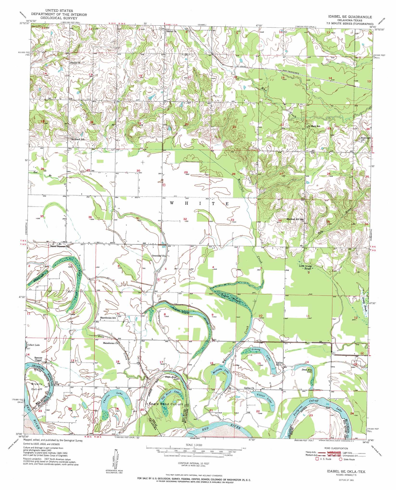
USGS Topo Quad 33094g7 - 1:24,000 scale
| Topo Map Name: | Idabel Se |
| USGS Topo Quad ID: | 33094g7 |
| Print Size: | ca. 21 1/4" wide x 27" high |
| Southeast Coordinates: | 33.75° N latitude / 94.75° W longitude |
| Map Center Coordinates: | 33.8125° N latitude / 94.8125° W longitude |
| U.S. States: | OK, TX |
| Filename: | o33094g7.jpg |
| Download Map JPG Image: | Idabel Se topo map 1:24,000 scale |
| Map Type: | Topographic |
| Topo Series: | 7.5´ |
| Map Scale: | 1:24,000 |
| Source of Map Images: | United States Geological Survey (USGS) |
| Alternate Map Versions: |
Idabel SE OK 1951 Download PDF Buy paper map Idabel SE OK 2010 Download PDF Buy paper map Idabel SE OK 2012 Download PDF Buy paper map Idabel SE OK 2016 Download PDF Buy paper map |
| FStopo: | US Forest Service topo Idabel SE is available: Download FStopo PDF Download FStopo TIF |
1:24,000 Topo Quads surrounding Idabel Se
Wright City |
Golden |
Steel Junction |
Broken Bow |
Eagletown |
Millerton |
Garvin |
Idabel |
Shults |
Goodwater |
Negley |
Acworth |
Idabel Se |
Haworth |
Bokhoma |
Dimple |
White Rock |
English |
De Kalb Nw |
Tom |
Clarksville |
Annona |
Avery |
Oak Grove |
De Kalb |
> Back to 33094e1 at 1:100,000 scale
> Back to 33094a1 at 1:250,000 scale
> Back to U.S. Topo Maps home
Idabel Se topo map: Gazetteer
Idabel Se: Bends
Bryarly Cut-off elevation 107m 351′Eagle Bend Cut-Off elevation 104m 341′
Idabel Se: Dams
Oknoname 089003 Dam elevation 129m 423′Oknoname 089012 Dam elevation 106m 347′
Oknoname 089016 Dam elevation 107m 351′
Waterfall-Gilford Creek Site 9 Dam elevation 109m 357′
Waterfall-Gilford Creeks Site 12 Dam elevation 106m 347′
Waterfall-Gilford Creeks Site 2 Dam elevation 113m 370′
Waterfall-Gilford Creeks Site 3 Dam elevation 113m 370′
Waterfall-Gilford Creeks Site 4 Dam elevation 110m 360′
Waterfall-Gilford Creeks Site 5 Dam elevation 114m 374′
Waterfall-Gilford Creeks Site 6 Dam elevation 107m 351′
Waterfall-Gilford Creeks Site 7 Dam elevation 110m 360′
Waterfall-Gilford Creeks Site 8 Dam elevation 110m 360′
Idabel Se: Guts
Jenkins Reilly Slough elevation 104m 341′Lewis Slough elevation 104m 341′
Little Grassy Slough elevation 106m 347′
Idabel Se: Lakes
Bryarly Lake elevation 104m 341′Charles Lake elevation 105m 344′
Dead Man Lake elevation 104m 341′
Eagle Bend Lake elevation 104m 341′
Forty-one Cut-off Lake elevation 100m 328′
Grassy Lake elevation 106m 347′
Mintubbe Lake elevation 103m 337′
Old River Lake elevation 103m 337′
Victor Lake elevation 103m 337′
Idabel Se: Reservoirs
Oknoname 089003 Reservoir elevation 129m 423′Oknoname 089012 Reservoir elevation 106m 347′
Oknoname 089016 Reservoir elevation 107m 351′
Waterfall-Gilford Creek Site 9 Reservoir elevation 109m 357′
Waterfall-Gilford Creeks Site 12 Reservoir elevation 106m 347′
Waterfall-Gilford Creeks Site 2 Reservoir elevation 113m 370′
Waterfall-Gilford Creeks Site 3 Reservoir elevation 113m 370′
Waterfall-Gilford Creeks Site 4 Reservoir elevation 110m 360′
Waterfall-Gilford Creeks Site 5 Reservoir elevation 114m 374′
Waterfall-Gilford Creeks Site 6 Reservoir elevation 107m 351′
Waterfall-Gilford Creeks Site 7 Reservoir elevation 110m 360′
Waterfall-Gilford Creeks Site 8 Reservoir elevation 110m 360′
Idabel Se: Streams
Boss Creek elevation 103m 337′Deadman Branch elevation 104m 341′
Deadman Branch elevation 104m 341′
Waterfall Creek elevation 102m 334′
Idabel Se: Swamps
Fish Pond elevation 107m 351′Gilford Lake elevation 107m 351′
Grassy Slough elevation 106m 347′
Idabel Se digital topo map on disk
Buy this Idabel Se topo map showing relief, roads, GPS coordinates and other geographical features, as a high-resolution digital map file on DVD: