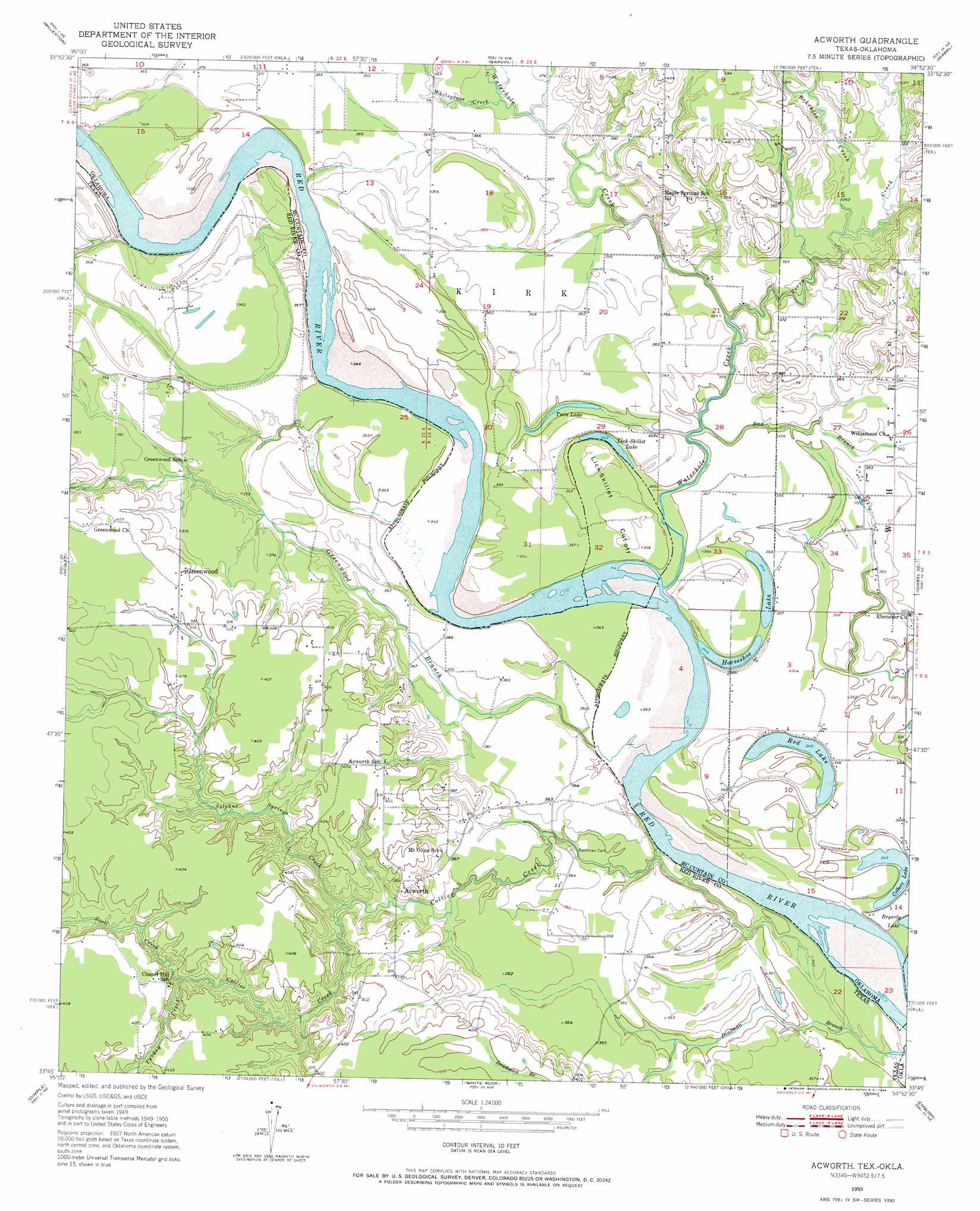
Acworth Topo Map Texas
To zoom in, hover over the map of Acworth
USGS Topo Quad 33094g8 - 1:24,000 scale
| Topo Map Name: | Acworth |
| USGS Topo Quad ID: | 33094g8 |
| Print Size: | ca. 21 1/4" wide x 27" high |
| Southeast Coordinates: | 33.75° N latitude / 94.875° W longitude |
| Map Center Coordinates: | 33.8125° N latitude / 94.9375° W longitude |
| U.S. States: | TX, OK |
| Filename: | o33094g8.jpg |
| Download Map JPG Image: | Acworth topo map 1:24,000 scale |
| Map Type: | Topographic |
| Topo Series: | 7.5´ |
| Map Scale: | 1:24,000 |
| Source of Map Images: | United States Geological Survey (USGS) |
| Alternate Map Versions: |
Acworth TX 1950, updated 1968 Download PDF Buy paper map Acworth TX 1951 Download PDF Buy paper map Acworth TX 2010 Download PDF Buy paper map Acworth TX 2013 Download PDF Buy paper map Acworth TX 2016 Download PDF Buy paper map |
1:24,000 Topo Quads surrounding Acworth
Swink |
Wright City |
Golden |
Steel Junction |
Broken Bow |
Kiomatia |
Millerton |
Garvin |
Idabel |
Shults |
Manchester |
Negley |
Acworth |
Idabel Se |
Haworth |
Bagwell |
Dimple |
White Rock |
English |
De Kalb Nw |
Line Branch |
Clarksville |
Annona |
Avery |
Oak Grove |
> Back to 33094e1 at 1:100,000 scale
> Back to 33094a1 at 1:250,000 scale
> Back to U.S. Topo Maps home
Acworth topo map: Gazetteer
Acworth: Bends
Lick-Skillet Cut-Off elevation 110m 360′Acworth: Dams
Oknoname 089004 Dam elevation 116m 380′Waterfall-Gilford Creeks Site 1 Dam elevation 106m 347′
Acworth: Lakes
Colbert Lake elevation 105m 344′Horseshoe Lake elevation 104m 341′
Lick-Skillet Lake elevation 105m 344′
Red Lake elevation 105m 344′
Twin Lake elevation 106m 347′
Acworth: Populated Places
Acworth elevation 120m 393′Greenwood elevation 122m 400′
Acworth: Reservoirs
Oknoname 089004 Reservoir elevation 116m 380′Waterfall-Gilford Creeks Site 1 Reservoir elevation 106m 347′
Acworth: Springs
Bryarly Springs elevation 107m 351′Acworth: Streams
Bad Branch elevation 107m 351′Bokchito Creek elevation 110m 360′
Collier Creek elevation 101m 331′
Greenwood Branch elevation 104m 341′
McKinsey Slough elevation 104m 341′
Perry Creek elevation 106m 347′
Snell Creek elevation 112m 367′
Sulpher Springs Creek elevation 108m 354′
Turkey Branch elevation 114m 374′
Waterhole Creek elevation 104m 341′
Whitegrass Creek elevation 110m 360′
Acworth digital topo map on disk
Buy this Acworth topo map showing relief, roads, GPS coordinates and other geographical features, as a high-resolution digital map file on DVD: