Sulphur Springs Topo Map Texas
To zoom in, hover over the map of Sulphur Springs
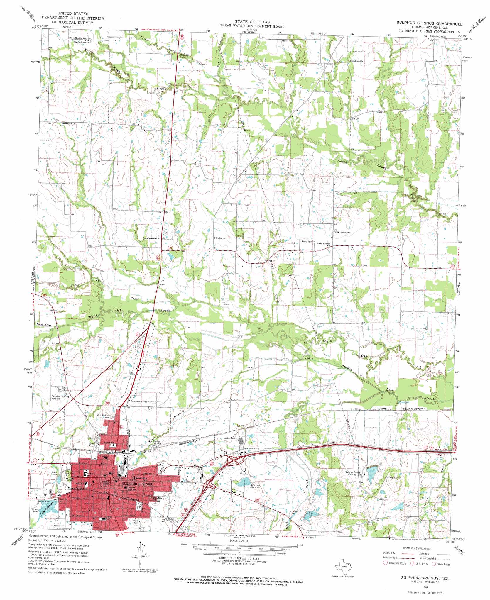
USGS Topo Quad 33095b5 - 1:24,000 scale
| Topo Map Name: | Sulphur Springs |
| USGS Topo Quad ID: | 33095b5 |
| Print Size: | ca. 21 1/4" wide x 27" high |
| Southeast Coordinates: | 33.125° N latitude / 95.5° W longitude |
| Map Center Coordinates: | 33.1875° N latitude / 95.5625° W longitude |
| U.S. State: | TX |
| Filename: | o33095b5.jpg |
| Download Map JPG Image: | Sulphur Springs topo map 1:24,000 scale |
| Map Type: | Topographic |
| Topo Series: | 7.5´ |
| Map Scale: | 1:24,000 |
| Source of Map Images: | United States Geological Survey (USGS) |
| Alternate Map Versions: |
Sulphur Springs TX 1964, updated 1968 Download PDF Buy paper map Sulphur Springs TX 2010 Download PDF Buy paper map Sulphur Springs TX 2013 Download PDF Buy paper map Sulphur Springs TX 2016 Download PDF Buy paper map |
1:24,000 Topo Quads surrounding Sulphur Springs
Pecan Gap |
Cooper North |
Charleston |
Minter |
Cunningham |
Klondike |
Cooper South |
Tira |
Sulphur Bluff |
Mitchell Creek |
Cumby |
Gafford Chapel |
Sulphur Springs |
Dike |
Saltillo |
Miller Grove |
Brashear |
Sulphur Springs Se |
Como |
Purley |
Emory North |
Arbala |
Yantis |
Pleasant Grove |
Winnsboro |
> Back to 33095a1 at 1:100,000 scale
> Back to 33094a1 at 1:250,000 scale
> Back to U.S. Topo Maps home
Sulphur Springs topo map: Gazetteer
Sulphur Springs: Airports
Sulphur Springs Municipal Airport elevation 144m 472′Sulphur Springs: Dams
Gooding Lake Dam elevation 142m 465′Helm Lake Number 1 Dam elevation 138m 452′
Helm Lake Number 2 Dam elevation 135m 442′
Helm Lake Number 3 Dam elevation 141m 462′
Lake Coleman Dam elevation 157m 515′
Sulphur Springs Country Club Dam elevation 133m 436′
Sulphur Springs Dam elevation 134m 439′
Sulphur Springs: Parks
Pacific Park elevation 155m 508′Suplhur Springs City Park elevation 158m 518′
Sulphur Springs: Populated Places
Sulphur Springs elevation 153m 501′Sulphur Springs: Reservoirs
Gooding Lake elevation 142m 465′Helm Lake Number 1 elevation 138m 452′
Helm Lake Number 2 elevation 135m 442′
Helm Lake Number 3 elevation 141m 462′
Lake Coleman elevation 157m 515′
Lake Sulphur Springs elevation 134m 439′
Sulphur Springs Country Club Lake elevation 133m 436′
Sulphur Springs: Streams
Black Creek elevation 134m 439′Horse Pen Creek elevation 128m 419′
Little Caney Creek elevation 134m 439′
Midget Creek elevation 125m 410′
Town Branch elevation 122m 400′
Wolf Creek elevation 135m 442′
Sulphur Springs digital topo map on disk
Buy this Sulphur Springs topo map showing relief, roads, GPS coordinates and other geographical features, as a high-resolution digital map file on DVD: