Lavon Topo Map Texas
To zoom in, hover over the map of Lavon
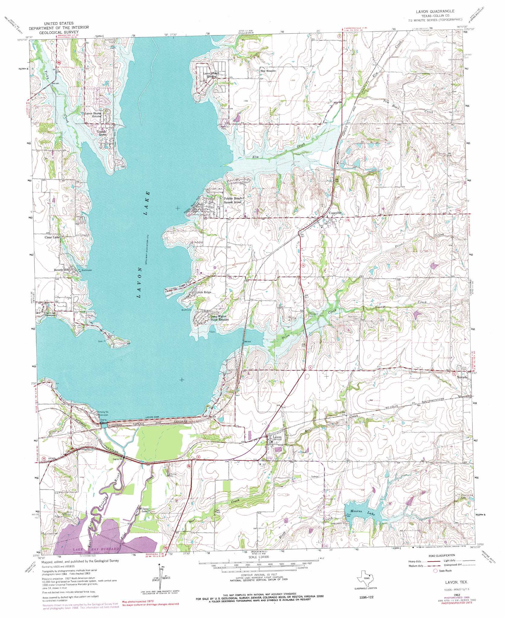
USGS Topo Quad 33096a4 - 1:24,000 scale
| Topo Map Name: | Lavon |
| USGS Topo Quad ID: | 33096a4 |
| Print Size: | ca. 21 1/4" wide x 27" high |
| Southeast Coordinates: | 33° N latitude / 96.375° W longitude |
| Map Center Coordinates: | 33.0625° N latitude / 96.4375° W longitude |
| U.S. State: | TX |
| Filename: | o33096a4.jpg |
| Download Map JPG Image: | Lavon topo map 1:24,000 scale |
| Map Type: | Topographic |
| Topo Series: | 7.5´ |
| Map Scale: | 1:24,000 |
| Source of Map Images: | United States Geological Survey (USGS) |
| Alternate Map Versions: |
Lavon TX 1963, updated 1964 Download PDF Buy paper map Lavon TX 1963, updated 1969 Download PDF Buy paper map Lavon TX 1963, updated 1978 Download PDF Buy paper map Lavon TX 2010 Download PDF Buy paper map Lavon TX 2013 Download PDF Buy paper map Lavon TX 2016 Download PDF Buy paper map |
1:24,000 Topo Quads surrounding Lavon
Weston |
Anna |
Blue Ridge |
Pike |
Celeste |
Mckinney West |
Mckinney East |
Culleoka |
Farmersville |
Greenville Nw |
Plano |
Wylie |
Lavon |
Josephine |
Greenville Sw |
Garland |
Rowlett |
Rockwall |
Royse City |
Quinlan |
White Rock Lake |
Mesquite |
Forney North |
Terrell North |
Poetry |
> Back to 33096a1 at 1:100,000 scale
> Back to 33096a1 at 1:250,000 scale
> Back to U.S. Topo Maps home
Lavon topo map: Gazetteer
Lavon: Dams
Bell Lake Dam elevation 167m 547′Boyd Lake Dam elevation 173m 567′
Lavon Dam elevation 148m 485′
Soil Conservation Service Site 2 Dam elevation 154m 505′
Lavon: Lakes
Wilson Lake elevation 136m 446′Lavon: Parks
Avalon Park elevation 153m 501′Clear Lake Park elevation 149m 488′
Cottonwood Park elevation 156m 511′
Culleoka Park elevation 159m 521′
Lakeland Park elevation 159m 521′
Lavonia Park elevation 154m 505′
Little Ridge Park elevation 151m 495′
Mallard Park elevation 162m 531′
Pebble Beach Park elevation 147m 482′
Ticky Creek Park elevation 151m 495′
Lavon: Populated Places
Beverly Hill elevation 156m 511′Clear Lake elevation 162m 531′
Copeville elevation 169m 554′
Deep Water Point Estates elevation 158m 518′
Lavon elevation 160m 524′
Lavon Beach Estates elevation 160m 524′
Lavon Shores Estates elevation 159m 521′
Little Ridge elevation 153m 501′
New Mesquite elevation 159m 521′
Pebble Beach Sunset Acres elevation 157m 515′
Yucote Acres elevation 158m 518′
Lavon: Reservoirs
Bell Lake elevation 167m 547′Boyd Lake elevation 173m 567′
Lavon Lake elevation 151m 495′
Moores Lake elevation 155m 508′
Soil Conservation Service Site 2 Reservoir elevation 154m 505′
Lavon: Streams
Elm Creek elevation 144m 472′George Creek elevation 149m 488′
Price Creek elevation 149m 488′
Ticky Creek elevation 144m 472′
Tom Bean Creek elevation 152m 498′
Lavon digital topo map on disk
Buy this Lavon topo map showing relief, roads, GPS coordinates and other geographical features, as a high-resolution digital map file on DVD: