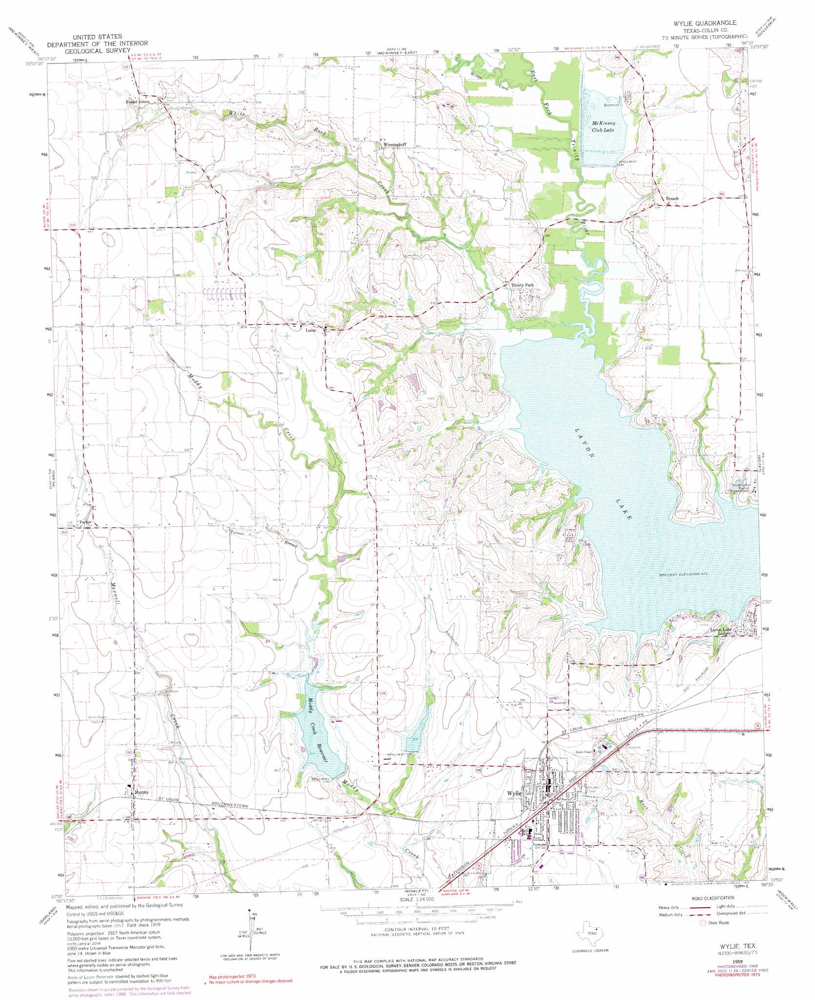
Wylie Topo Map Texas
To zoom in, hover over the map of Wylie
USGS Topo Quad 33096a5 - 1:24,000 scale
| Topo Map Name: | Wylie |
| USGS Topo Quad ID: | 33096a5 |
| Print Size: | ca. 21 1/4" wide x 27" high |
| Southeast Coordinates: | 33° N latitude / 96.5° W longitude |
| Map Center Coordinates: | 33.0625° N latitude / 96.5625° W longitude |
| U.S. State: | TX |
| Filename: | o33096a5.jpg |
| Download Map JPG Image: | Wylie topo map 1:24,000 scale |
| Map Type: | Topographic |
| Topo Series: | 7.5´ |
| Map Scale: | 1:24,000 |
| Source of Map Images: | United States Geological Survey (USGS) |
| Alternate Map Versions: |
Wylie TX 1959, updated 1961 Download PDF Buy paper map Wylie TX 1959, updated 1968 Download PDF Buy paper map Wylie TX 1959, updated 1969 Download PDF Buy paper map Wylie TX 1959, updated 1976 Download PDF Buy paper map Wylie TX 2010 Download PDF Buy paper map Wylie TX 2013 Download PDF Buy paper map Wylie TX 2016 Download PDF Buy paper map |
1:24,000 Topo Quads surrounding Wylie
Celina |
Weston |
Anna |
Blue Ridge |
Pike |
Frisco |
Mckinney West |
Mckinney East |
Culleoka |
Farmersville |
Hebron |
Plano |
Wylie |
Lavon |
Josephine |
Addison |
Garland |
Rowlett |
Rockwall |
Royse City |
Dallas |
White Rock Lake |
Mesquite |
Forney North |
Terrell North |
> Back to 33096a1 at 1:100,000 scale
> Back to 33096a1 at 1:250,000 scale
> Back to U.S. Topo Maps home
Wylie topo map: Gazetteer
Wylie: Airports
Aero Crafter Incorporated Heliport elevation 166m 544′Ladue Ranch Heliport elevation 159m 521′
Putman Heliport elevation 168m 551′
Walden Ranch Heliport elevation 159m 521′
Wylie: Dams
Lago Grande Dam elevation 157m 515′Monroe Lake Dam elevation 166m 544′
Sies Lagos Number 5 Dam elevation 162m 531′
Soil Conservation Service Site 4 Dam elevation 156m 511′
Soil Conservation Service Site 5 Dam elevation 157m 515′
Texas No Name Number 25 Dam elevation 162m 531′
Wylie: Parks
Bratonia Park elevation 161m 528′Brockdale Park elevation 155m 508′
Collin Park elevation 165m 541′
East Fork Park elevation 156m 511′
Highland Park elevation 154m 505′
Pirate Field elevation 164m 538′
Wylie: Populated Places
Branch elevation 159m 521′Forest Grove elevation 186m 610′
Lavon Lake Lodges elevation 156m 511′
Lucas elevation 173m 567′
Murphy elevation 177m 580′
Parker elevation 184m 603′
Saint Paul elevation 172m 564′
Trinity Park elevation 161m 528′
Winningkoff elevation 171m 561′
Wylie elevation 170m 557′
Wylie: Reservoirs
Lago Grande elevation 157m 515′McKinney Club Lake elevation 150m 492′
Monroe Lake elevation 166m 544′
Muddy Creek Reservoir elevation 156m 511′
Sies Lagos Number 5 elevation 162m 531′
Soil Conservation Service Site 4 Reservoir elevation 156m 511′
Soil Conservation Service Site 5 Reservoir elevation 157m 515′
Wylie: Streams
Turner Branch elevation 162m 531′White Rock Creek elevation 144m 472′
Wilson Creek elevation 146m 479′
Wylie: Trails
Trinity Trail elevation 157m 515′Wylie Community Park Trail elevation 158m 518′
Wylie digital topo map on disk
Buy this Wylie topo map showing relief, roads, GPS coordinates and other geographical features, as a high-resolution digital map file on DVD: