Lewisville East Topo Map Texas
To zoom in, hover over the map of Lewisville East
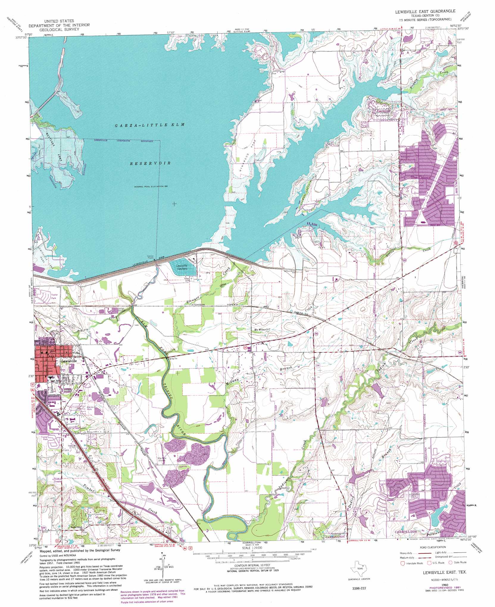
USGS Topo Quad 33096a8 - 1:24,000 scale
| Topo Map Name: | Lewisville East |
| USGS Topo Quad ID: | 33096a8 |
| Print Size: | ca. 21 1/4" wide x 27" high |
| Southeast Coordinates: | 33° N latitude / 96.875° W longitude |
| Map Center Coordinates: | 33.0625° N latitude / 96.9375° W longitude |
| U.S. State: | TX |
| Filename: | o33096a8.jpg |
| Download Map JPG Image: | Lewisville East topo map 1:24,000 scale |
| Map Type: | Topographic |
| Topo Series: | 7.5´ |
| Map Scale: | 1:24,000 |
| Source of Map Images: | United States Geological Survey (USGS) |
| Alternate Map Versions: |
Lewisville East TX 1960, updated 1962 Download PDF Buy paper map Lewisville East TX 1960, updated 1967 Download PDF Buy paper map Lewisville East TX 1960, updated 1969 Download PDF Buy paper map Lewisville East TX 1960, updated 1974 Download PDF Buy paper map Lewisville East TX 1960, updated 1982 Download PDF Buy paper map Lewisville East TX 2010 Download PDF Buy paper map Lewisville East TX 2013 Download PDF Buy paper map Lewisville East TX 2016 Download PDF Buy paper map |
1:24,000 Topo Quads surrounding Lewisville East
Sanger |
Green Valley |
Aubrey |
Celina |
Weston |
Denton West |
Denton East |
Little Elm |
Frisco |
Mckinney West |
Argyle |
Lewisville West |
Lewisville East |
Hebron |
Plano |
Colleyville |
Grapevine |
Carrollton |
Addison |
Garland |
Hurst |
Euless |
Irving |
Dallas |
White Rock Lake |
> Back to 33096a1 at 1:100,000 scale
> Back to 33096a1 at 1:250,000 scale
> Back to U.S. Topo Maps home
Lewisville East topo map: Gazetteer
Lewisville East: Crossings
Interchange 448A elevation 143m 469′Interchange 449 elevation 148m 485′
Interchange 450 elevation 161m 528′
Lewisville East: Dams
Bright Lake Dam elevation 154m 505′Colonial House Lake Dam elevation 156m 511′
Lewisville Dam elevation 148m 485′
Underwood Lake Dam elevation 158m 518′
Lewisville East: Parks
American Indoor Sports Facility elevation 140m 459′Delay Middle School Football Field elevation 160m 524′
East Hill Park elevation 168m 551′
Eastvale Park elevation 168m 551′
Griffin Middle School Football Field elevation 176m 577′
Stewart Creek Park elevation 161m 528′
Tommy Briggs Cougar Stadium elevation 179m 587′
Wynnwood Park elevation 164m 538′
Lewisville East: Populated Places
Lewisville elevation 160m 524′The Colony elevation 180m 590′
Lewisville East: Post Offices
Old Town Finance Post Office elevation 161m 528′Rosemeade Post Office elevation 172m 564′
The Colony Post Office elevation 184m 603′
Lewisville East: Reservoirs
Bright Lake elevation 154m 505′Colonial House Lake elevation 156m 511′
Lake Lewisville elevation 171m 561′
Underwood Lake elevation 158m 518′
Lewisville East: Streams
Indian Creek elevation 137m 449′McWhorter Creek elevation 139m 456′
Midway Branch elevation 135m 442′
Office Creek elevation 140m 459′
Prairie Creek elevation 138m 452′
Stewart Creek elevation 134m 439′
Lewisville East digital topo map on disk
Buy this Lewisville East topo map showing relief, roads, GPS coordinates and other geographical features, as a high-resolution digital map file on DVD: