Farmersville Topo Map Texas
To zoom in, hover over the map of Farmersville
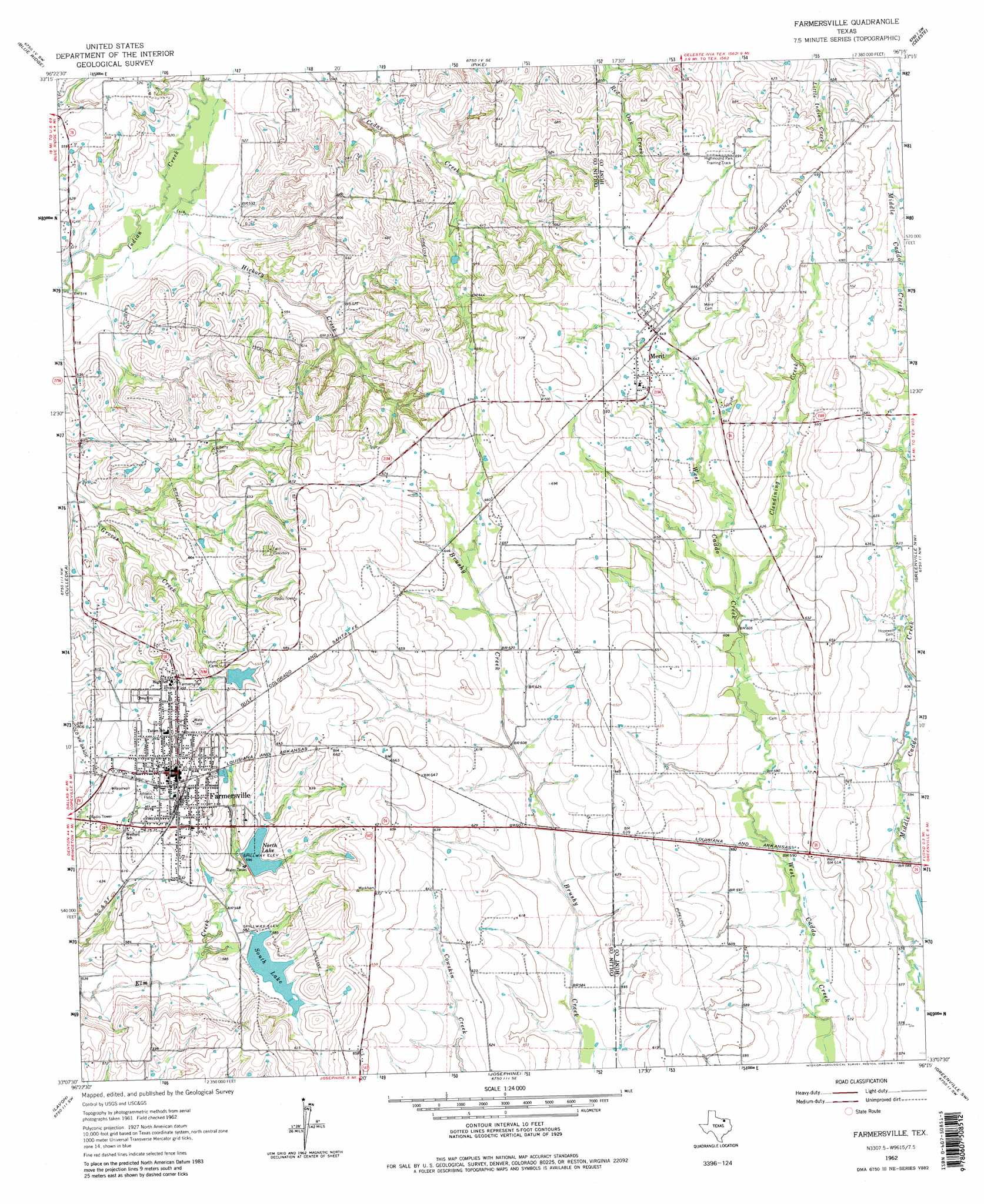
USGS Topo Quad 33096b3 - 1:24,000 scale
| Topo Map Name: | Farmersville |
| USGS Topo Quad ID: | 33096b3 |
| Print Size: | ca. 21 1/4" wide x 27" high |
| Southeast Coordinates: | 33.125° N latitude / 96.25° W longitude |
| Map Center Coordinates: | 33.1875° N latitude / 96.3125° W longitude |
| U.S. State: | TX |
| Filename: | o33096b3.jpg |
| Download Map JPG Image: | Farmersville topo map 1:24,000 scale |
| Map Type: | Topographic |
| Topo Series: | 7.5´ |
| Map Scale: | 1:24,000 |
| Source of Map Images: | United States Geological Survey (USGS) |
| Alternate Map Versions: |
Farmersville TX 1962, updated 1965 Download PDF Buy paper map Farmersville TX 1962, updated 1980 Download PDF Buy paper map Farmersville TX 1962, updated 1980 Download PDF Buy paper map Farmersville TX 2010 Download PDF Buy paper map Farmersville TX 2013 Download PDF Buy paper map Farmersville TX 2016 Download PDF Buy paper map |
1:24,000 Topo Quads surrounding Farmersville
Van Alstyne |
Pilot Grove |
Trenton |
Leonard |
Gober |
Anna |
Blue Ridge |
Pike |
Celeste |
Wolfe City |
Mckinney East |
Culleoka |
Farmersville |
Greenville Nw |
Greenville Ne |
Wylie |
Lavon |
Josephine |
Greenville Sw |
Greenville Se |
Rowlett |
Rockwall |
Royse City |
Quinlan |
West Tawakoni |
> Back to 33096a1 at 1:100,000 scale
> Back to 33096a1 at 1:250,000 scale
> Back to U.S. Topo Maps home
Farmersville topo map: Gazetteer
Farmersville: Airports
Flying m Airport elevation 178m 583′Short Stop Airport elevation 197m 646′
Farmersville: Dams
Soil Conservation Service Site 73 Dam elevation 171m 561′Soil Conservation Service Site 75 Dam elevation 175m 574′
Soil Conservation Service Site 76 Dam elevation 179m 587′
Soil Conservation Service Site 77 Dam elevation 164m 538′
Soil Conservation Service Site 79 Dam elevation 171m 561′
Soil Conservation Service Site 80 Dam elevation 171m 561′
Soil Conservation Service Site 82 Dam elevation 177m 580′
Soil Conservation Service Site 83a Dam elevation 181m 593′
Tatum Dam elevation 194m 636′
Farmersville: Parks
Farmer Stadium elevation 203m 666′J W Spain Athletic Complex elevation 203m 666′
Farmersville: Populated Places
Farmersville elevation 199m 652′Merit elevation 198m 649′
Farmersville: Reservoirs
North Lake elevation 182m 597′Soil Conservation Service Site 73 Reservoir elevation 171m 561′
Soil Conservation Service Site 75 Reservoir elevation 175m 574′
Soil Conservation Service Site 76 Reservoir elevation 179m 587′
Soil Conservation Service Site 77 Reservoir elevation 164m 538′
Soil Conservation Service Site 79 Reservoir elevation 171m 561′
Soil Conservation Service Site 80 Reservoir elevation 171m 561′
Soil Conservation Service Site 82 Reservoir elevation 177m 580′
Soil Conservation Service Site 83a Reservoir elevation 181m 593′
South Lake elevation 178m 583′
Tatum Lake elevation 194m 636′
Farmersville: Streams
Clendining Creek elevation 186m 610′Hickory Creek elevation 156m 511′
Farmersville digital topo map on disk
Buy this Farmersville topo map showing relief, roads, GPS coordinates and other geographical features, as a high-resolution digital map file on DVD: