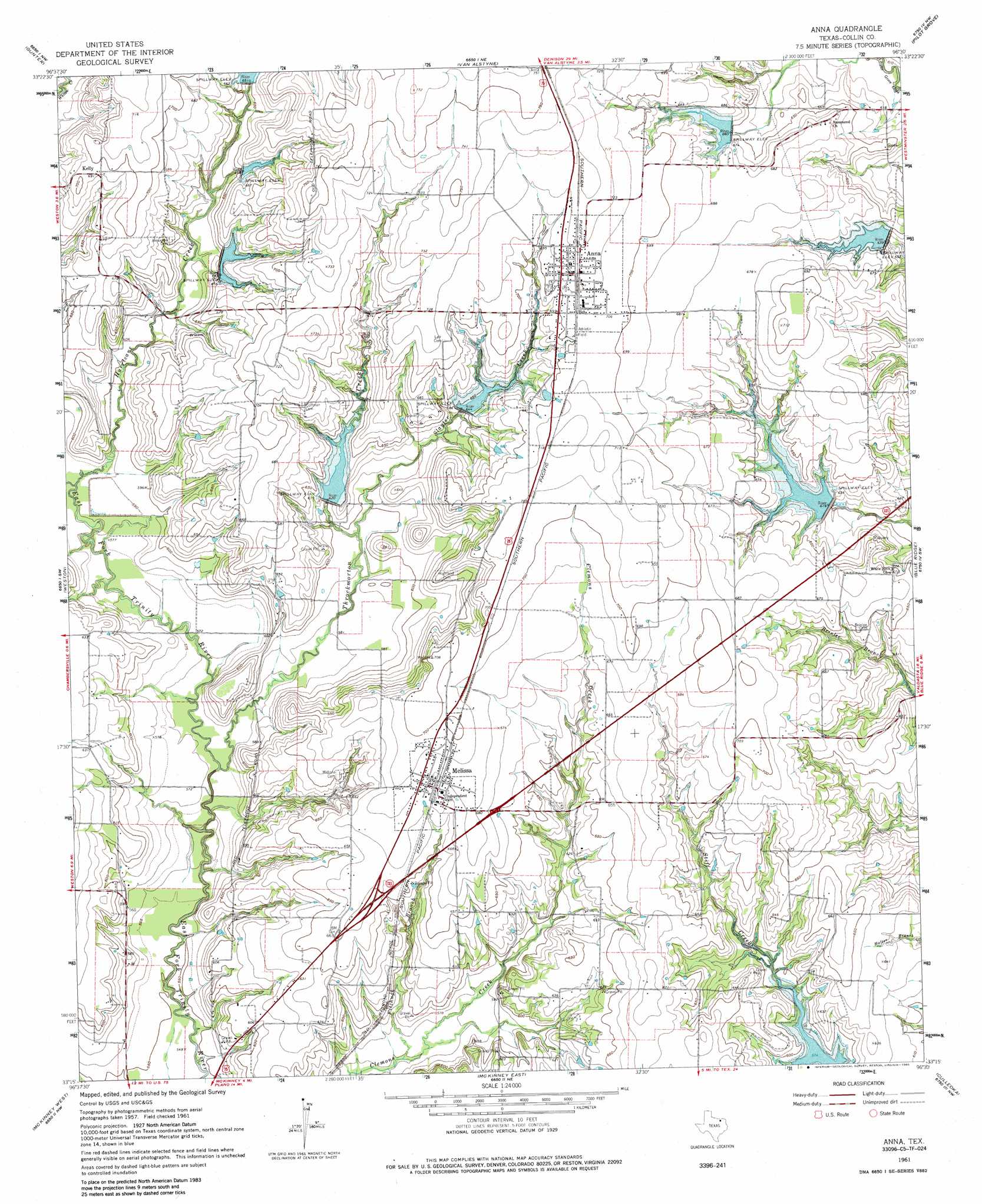
Anna Topo Map Texas
To zoom in, hover over the map of Anna
USGS Topo Quad 33096c5 - 1:24,000 scale
| Topo Map Name: | Anna |
| USGS Topo Quad ID: | 33096c5 |
| Print Size: | ca. 21 1/4" wide x 27" high |
| Southeast Coordinates: | 33.25° N latitude / 96.5° W longitude |
| Map Center Coordinates: | 33.3125° N latitude / 96.5625° W longitude |
| U.S. State: | TX |
| Filename: | o33096c5.jpg |
| Download Map JPG Image: | Anna topo map 1:24,000 scale |
| Map Type: | Topographic |
| Topo Series: | 7.5´ |
| Map Scale: | 1:24,000 |
| Source of Map Images: | United States Geological Survey (USGS) |
| Alternate Map Versions: |
Anna TX 1961, updated 1963 Download PDF Buy paper map Anna TX 1961, updated 1975 Download PDF Buy paper map Anna TX 1961, updated 1985 Download PDF Buy paper map Anna TX 2010 Download PDF Buy paper map Anna TX 2013 Download PDF Buy paper map Anna TX 2016 Download PDF Buy paper map |
1:24,000 Topo Quads surrounding Anna
Ethel |
Dorchester |
Howe |
Whitewright |
Ector |
Marilee |
Gunter |
Van Alstyne |
Pilot Grove |
Trenton |
Celina |
Weston |
Anna |
Blue Ridge |
Pike |
Frisco |
Mckinney West |
Mckinney East |
Culleoka |
Farmersville |
Hebron |
Plano |
Wylie |
Lavon |
Josephine |
> Back to 33096a1 at 1:100,000 scale
> Back to 33096a1 at 1:250,000 scale
> Back to U.S. Topo Maps home
Anna topo map: Gazetteer
Anna: Dams
Meat Producers Dam elevation 195m 639′Soil Conservation Service Site 43 Dam elevation 192m 629′
Soil Conservation Service Site 44 Dam elevation 200m 656′
Soil Conservation Service Site 45 Dam elevation 199m 652′
Soil Conservation Service Site 46 Dam elevation 191m 626′
Soil Conservation Service Site 47 Dam elevation 194m 636′
Soil Conservation Service Site 48 Dam elevation 179m 587′
Soil Conservation Service Site 6 Dam elevation 204m 669′
Soil Conservation Service Site 7 Dam elevation 198m 649′
Soil Conservation Service Site 8 Dam elevation 199m 652′
Soil Conservation Service Site 9 Dam elevation 194m 636′
Anna: Populated Places
Anna elevation 217m 711′Kelly elevation 210m 688′
Melissa elevation 207m 679′
Parris (historical) elevation 168m 551′
Anna: Reservoirs
Meat Producers Reservoir elevation 195m 639′Soil Conservation Service Site 43 Reservoir elevation 192m 629′
Soil Conservation Service Site 44 Reservoir elevation 200m 656′
Soil Conservation Service Site 45 Reservoir elevation 199m 652′
Soil Conservation Service Site 46 Reservoir elevation 191m 626′
Soil Conservation Service Site 47 Reservoir elevation 194m 636′
Soil Conservation Service Site 48 Reservoir elevation 179m 587′
Soil Conservation Service Site 6 Reservoir elevation 204m 669′
Soil Conservation Service Site 7 Reservoir elevation 198m 649′
Soil Conservation Service Site 8 Reservoir elevation 199m 652′
Soil Conservation Service Site 9 Reservoir elevation 194m 636′
Anna: Streams
Fitzhugh Branch elevation 171m 561′Hurricane Creek elevation 177m 580′
Slayter Creek elevation 180m 590′
Throckmorton Creek elevation 171m 561′
Anna digital topo map on disk
Buy this Anna topo map showing relief, roads, GPS coordinates and other geographical features, as a high-resolution digital map file on DVD: