Denton East Topo Map Texas
To zoom in, hover over the map of Denton East
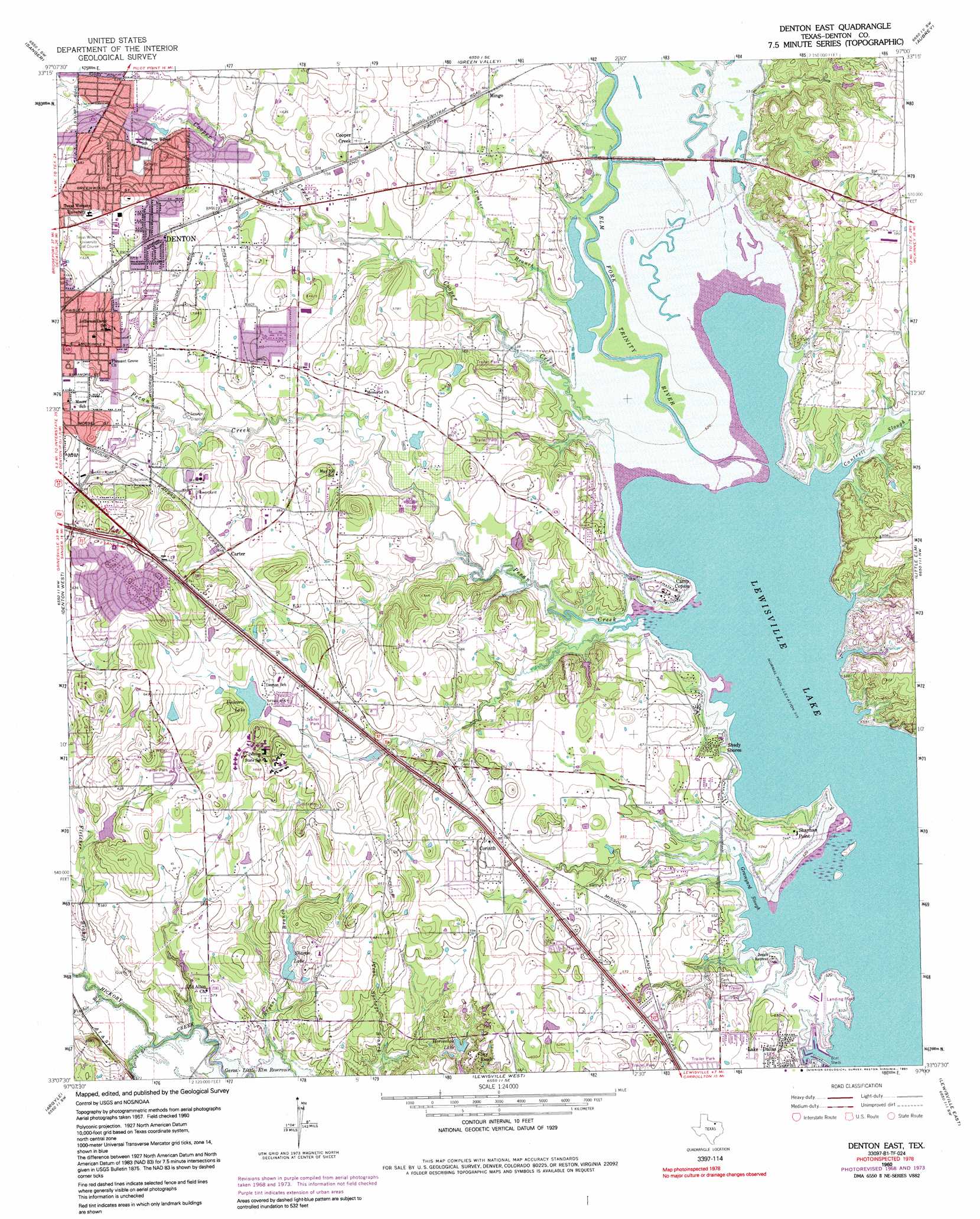
USGS Topo Quad 33097b1 - 1:24,000 scale
| Topo Map Name: | Denton East |
| USGS Topo Quad ID: | 33097b1 |
| Print Size: | ca. 21 1/4" wide x 27" high |
| Southeast Coordinates: | 33.125° N latitude / 97° W longitude |
| Map Center Coordinates: | 33.1875° N latitude / 97.0625° W longitude |
| U.S. State: | TX |
| Filename: | o33097b1.jpg |
| Download Map JPG Image: | Denton East topo map 1:24,000 scale |
| Map Type: | Topographic |
| Topo Series: | 7.5´ |
| Map Scale: | 1:24,000 |
| Source of Map Images: | United States Geological Survey (USGS) |
| Alternate Map Versions: |
Denton East TX 1960, updated 1962 Download PDF Buy paper map Denton East TX 1960, updated 1969 Download PDF Buy paper map Denton East TX 1960, updated 1974 Download PDF Buy paper map Denton East TX 1960, updated 1985 Download PDF Buy paper map Denton East TX 1960, updated 1991 Download PDF Buy paper map Denton East TX 2010 Download PDF Buy paper map Denton East TX 2013 Download PDF Buy paper map Denton East TX 2016 Download PDF Buy paper map |
1:24,000 Topo Quads surrounding Denton East
Era |
Valley View |
Mountain Springs |
Pilot Point |
Marilee |
Era Se |
Sanger |
Green Valley |
Aubrey |
Celina |
Ponder |
Denton West |
Denton East |
Little Elm |
Frisco |
Justin |
Argyle |
Lewisville West |
Lewisville East |
Hebron |
Keller |
Colleyville |
Grapevine |
Carrollton |
Addison |
> Back to 33097a1 at 1:100,000 scale
> Back to 33096a1 at 1:250,000 scale
> Back to U.S. Topo Maps home
Denton East topo map: Gazetteer
Denton East: Airports
Hidden Valley Airpark elevation 185m 606′Lakeview Airport elevation 162m 531′
Denton East: Bays
Graveyard Slough elevation 157m 515′Denton East: Bridges
Old Alton Bridge elevation 156m 511′Denton East: Cliffs
Shayhan Point elevation 162m 531′Denton East: Dams
Galbraith Lake Dam elevation 187m 613′John Knox Village Lake Dam elevation 185m 606′
Lake Sharon Dam elevation 167m 547′
Denton East: Parks
Big Sandy Park elevation 162m 531′Falcon Stadium elevation 192m 629′
Fish Trap Park elevation 161m 528′
Mack Park elevation 188m 616′
Moore Park elevation 186m 610′
Phoenix Park elevation 183m 600′
Schultz Park elevation 193m 633′
Schultz Park elevation 194m 636′
Skiles Park elevation 202m 662′
Woodrow Park elevation 180m 590′
Denton East: Populated Places
Carter elevation 193m 633′Cooper Creek elevation 184m 603′
Corinth elevation 185m 606′
Cross Roads elevation 183m 600′
Mayhill elevation 174m 570′
Mingo elevation 177m 580′
Shady Shores elevation 164m 538′
Denton East: Reservoirs
Galbraith Lake elevation 187m 613′Horseshoe Lake elevation 164m 538′
John Knox Village Lake elevation 185m 606′
Lake Sharon elevation 167m 547′
Sharon Lake elevation 168m 551′
Unicorn Lake elevation 187m 613′
Denton East: Streams
Cantrell Slough elevation 157m 515′Cooper Creek elevation 157m 515′
Fincher Branch elevation 160m 524′
Fletcher Branch elevation 160m 524′
Loving Branch elevation 156m 511′
Pecan Creek elevation 157m 515′
Timber Branch elevation 161m 528′
Denton East: Trails
Rail Trail elevation 181m 593′Denton East digital topo map on disk
Buy this Denton East topo map showing relief, roads, GPS coordinates and other geographical features, as a high-resolution digital map file on DVD: