Forestburg Topo Map Texas
To zoom in, hover over the map of Forestburg
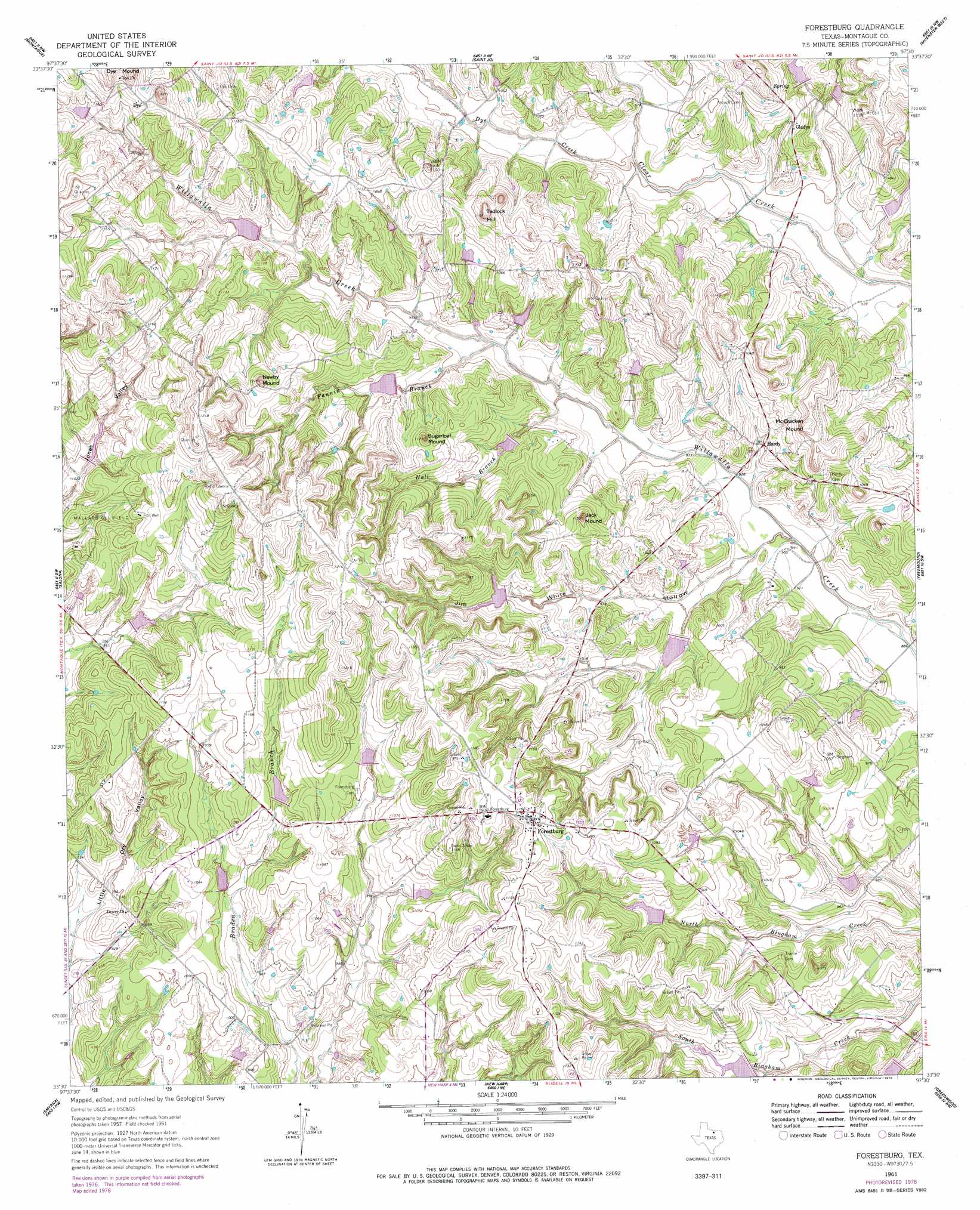
USGS Topo Quad 33097e5 - 1:24,000 scale
| Topo Map Name: | Forestburg |
| USGS Topo Quad ID: | 33097e5 |
| Print Size: | ca. 21 1/4" wide x 27" high |
| Southeast Coordinates: | 33.5° N latitude / 97.5° W longitude |
| Map Center Coordinates: | 33.5625° N latitude / 97.5625° W longitude |
| U.S. State: | TX |
| Filename: | o33097e5.jpg |
| Download Map JPG Image: | Forestburg topo map 1:24,000 scale |
| Map Type: | Topographic |
| Topo Series: | 7.5´ |
| Map Scale: | 1:24,000 |
| Source of Map Images: | United States Geological Survey (USGS) |
| Alternate Map Versions: |
Forestburg TX 1961, updated 1963 Download PDF Buy paper map Forestburg TX 1961, updated 1978 Download PDF Buy paper map Forestburg TX 2010 Download PDF Buy paper map Forestburg TX 2013 Download PDF Buy paper map Forestburg TX 2016 Download PDF Buy paper map |
1:24,000 Topo Quads surrounding Forestburg
Belcherville |
Nocona |
Bonita |
Leon South |
Marysville |
Buzzard Roost Knob |
Montague |
Saint Jo |
Muenster West |
Muenster East |
Bowie |
Salona |
Forestburg |
Freemound |
Hood |
Sunset |
Smyrna |
New Harp |
Greenwood |
Era |
Chico |
Alvord |
Pecan Creek |
Slidell |
Era Se |
> Back to 33097e1 at 1:100,000 scale
> Back to 33096a1 at 1:250,000 scale
> Back to U.S. Topo Maps home
Forestburg topo map: Gazetteer
Forestburg: Dams
Gaylord Lake Number 1 Dam elevation 307m 1007′Gaylord Lake Number 2 Dam elevation 315m 1033′
Soil Conservation Service Sediment Control Structure 103 elevation 325m 1066′
Soil Conservation Service Sediment Control Structure 104 elevation 347m 1138′
Soil Conservation Service Sediment Control Structure 105 elevation 313m 1026′
Soil Conservation Service Sediment Control Structure 106 elevation 298m 977′
Soil Conservation Service Sediment Control Structure 107 elevation 299m 980′
Soil Conservation Service Sediment Control Structure 109 elevation 291m 954′
Soil Conservation Service Sediment Control Structure 111 elevation 302m 990′
Soil Conservation Service Sediment Control Structure 112 elevation 308m 1010′
Soil Conservation Service Sediment Control Structure 113 elevation 317m 1040′
Soil Conservation Service Sediment Control Structure 16-1 elevation 300m 984′
Soil Conservation Service Sediment Control Structure 16-2 elevation 285m 935′
Soil Conservation Service Sediment Control Structure 7-6 elevation 294m 964′
Soil Conservation Service Site 12 Dam elevation 303m 994′
Soil Conservation Service Site 13 Dam elevation 303m 994′
Soil Conservation Service Site 14 Dam elevation 294m 964′
Soil Conservation Service Site 22 Dam elevation 318m 1043′
Soil Conservation Service Site 23 Dam elevation 313m 1026′
Soil Conservation Service Site 24 Dam elevation 307m 1007′
Soil Conservation Service Site 25 Dam elevation 318m 1043′
Soil Conservation Service Site 26 Dam elevation 293m 961′
Soil Conservation Service Site 27 Dam elevation 313m 1026′
Soil Conservation Service Site 28 Dam elevation 282m 925′
Soil Conservation Service Site 29 Dam elevation 298m 977′
Soil Conservation Service Site 30 Dam elevation 285m 935′
Soil Conservation Service Site 7b Dam elevation 314m 1030′
Soil Conservation Service Site 7d Dam elevation 320m 1049′
Soil Conservation Service Site 9a Dam elevation 316m 1036′
Soil Conservation Service Site 9b Dam elevation 320m 1049′
Soil Conservation Service Site 9c Dam elevation 305m 1000′
Soil Conservation Service Site 9d Dam elevation 309m 1013′
Forestburg: Populated Places
Dye elevation 360m 1181′Forestburg elevation 355m 1164′
Gladys elevation 314m 1030′
Hardy elevation 300m 984′
Forestburg: Reservoirs
Gaylord Lake Number 1 elevation 307m 1007′Gaylord Lake Number 2 elevation 315m 1033′
Sediment Control Structure 112 Reservoir elevation 308m 1010′
Sediment Control Structure 7-6 Reservoir elevation 294m 964′
Soil Conservation Service Sediment Control Structure 103 elevation 325m 1066′
Soil Conservation Service Sediment Control Structure 104 Reservoir elevation 347m 1138′
Soil Conservation Service Sediment Control Structure 105 Reservoir elevation 313m 1026′
Soil Conservation Service Sediment Control Structure 106 Reservoir elevation 298m 977′
Soil Conservation Service Sediment Control Structure 107 Reservoir elevation 299m 980′
Soil Conservation Service Sediment Control Structure 109 Reservoir elevation 291m 954′
Soil Conservation Service Sediment Control Structure 111 Reservoir elevation 302m 990′
Soil Conservation Service Sediment Control Structure 113 Reservoir elevation 317m 1040′
Soil Conservation Service Sediment Control Structure 16-1 Reservoir elevation 300m 984′
Soil Conservation Service Sediment Control Structure 16-2 Reservoir elevation 285m 935′
Soil Conservation Service Site 12 Reservoir elevation 303m 994′
Soil Conservation Service Site 13 Reservoir elevation 303m 994′
Soil Conservation Service Site 14 Reservoir elevation 294m 964′
Soil Conservation Service Site 22 Reservoir elevation 318m 1043′
Soil Conservation Service Site 23 Reservoir elevation 313m 1026′
Soil Conservation Service Site 24 Reservoir elevation 307m 1007′
Soil Conservation Service Site 25 Reservoir elevation 318m 1043′
Soil Conservation Service Site 26 Reservoir elevation 293m 961′
Soil Conservation Service Site 27 Reservoir elevation 313m 1026′
Soil Conservation Service Site 28 Reservoir elevation 282m 925′
Soil Conservation Service Site 29 Reservoir elevation 298m 977′
Soil Conservation Service Site 30 Reservoir elevation 285m 935′
Soil Conservation Service Site 7b Reservoir elevation 314m 1030′
Soil Conservation Service Site 7d Reservoir elevation 320m 1049′
Soil Conservation Service Site 9a Reservoir elevation 316m 1036′
Soil Conservation Service Site 9b Reservoir elevation 320m 1049′
Soil Conservation Service Site 9c Reservoir elevation 305m 1000′
Soil Conservation Service Site 9d Reservoir elevation 309m 1013′
Forestburg: Streams
Dye Creek elevation 289m 948′Fannin Branch elevation 292m 958′
Hall Branch elevation 286m 938′
Forestburg: Summits
Dye Mound elevation 388m 1272′Jack Mound elevation 348m 1141′
McCracken Mound elevation 343m 1125′
Newby Mound elevation 368m 1207′
Sugarloaf Mound elevation 356m 1167′
Tadlock Hill elevation 362m 1187′
Forestburg: Valleys
Jim White Hollow elevation 278m 912′Forestburg digital topo map on disk
Buy this Forestburg topo map showing relief, roads, GPS coordinates and other geographical features, as a high-resolution digital map file on DVD: