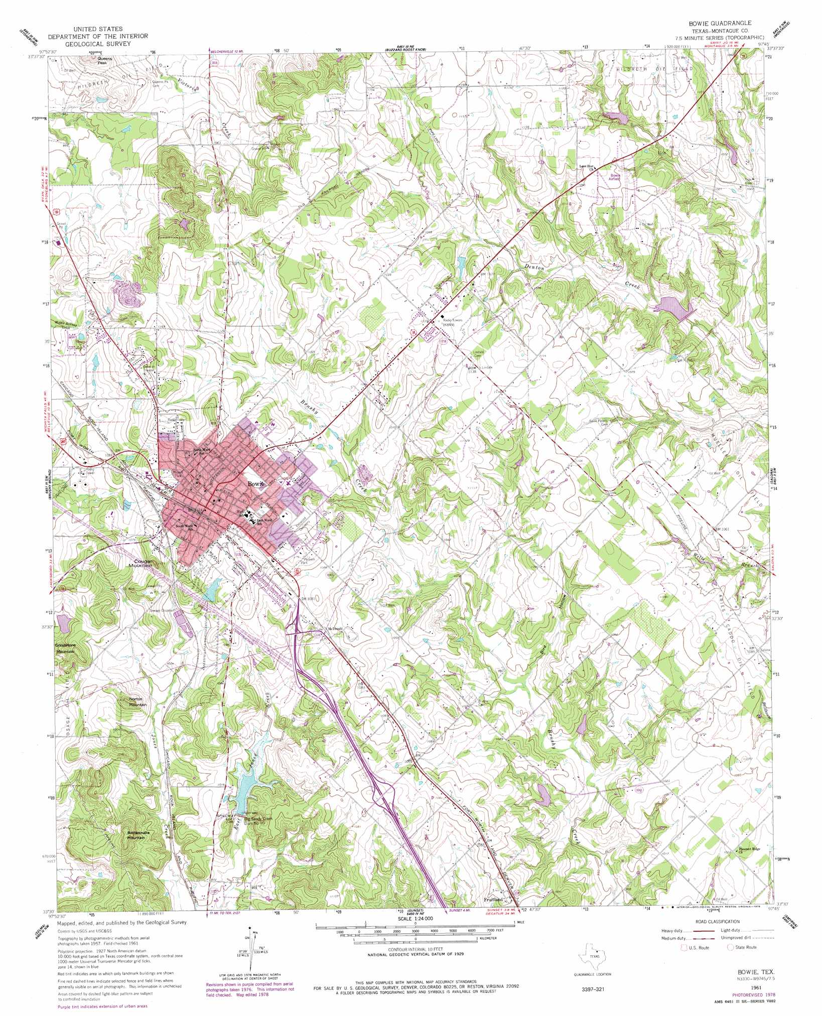
Bowie Topo Map Texas
To zoom in, hover over the map of Bowie
USGS Topo Quad 33097e7 - 1:24,000 scale
| Topo Map Name: | Bowie |
| USGS Topo Quad ID: | 33097e7 |
| Print Size: | ca. 21 1/4" wide x 27" high |
| Southeast Coordinates: | 33.5° N latitude / 97.75° W longitude |
| Map Center Coordinates: | 33.5625° N latitude / 97.8125° W longitude |
| U.S. State: | TX |
| Filename: | o33097e7.jpg |
| Download Map JPG Image: | Bowie topo map 1:24,000 scale |
| Map Type: | Topographic |
| Topo Series: | 7.5´ |
| Map Scale: | 1:24,000 |
| Source of Map Images: | United States Geological Survey (USGS) |
| Alternate Map Versions: |
Bowie TX 1961, updated 1963 Download PDF Buy paper map Bowie TX 1961, updated 1978 Download PDF Buy paper map Bowie TX 2010 Download PDF Buy paper map Bowie TX 2013 Download PDF Buy paper map Bowie TX 2016 Download PDF Buy paper map |
1:24,000 Topo Quads surrounding Bowie
Dickworsham |
Ringgold |
Belcherville |
Nocona |
Bonita |
Bellevue |
Stoneburg |
Buzzard Roost Knob |
Montague |
Saint Jo |
Vashti |
Brushy Mound |
Bowie |
Salona |
Forestburg |
Newport |
Selma |
Sunset |
Smyrna |
New Harp |
Cundiff |
Crafton |
Chico |
Alvord |
Pecan Creek |
> Back to 33097e1 at 1:100,000 scale
> Back to 33096a1 at 1:250,000 scale
> Back to U.S. Topo Maps home
Bowie topo map: Gazetteer
Bowie: Airports
Bowie Municipal Airport elevation 333m 1092′Bowie: Dams
Big Sandy Creek Dam Number 10 elevation 304m 997′Mose Johnson Lake Dam elevation 323m 1059′
Soil Conservation Service Site 10 Dam elevation 297m 974′
Soil Conservation Service Site 18 Dam elevation 299m 980′
Soil Conservation Service Site 1a Dam elevation 306m 1003′
Soil Conservation Service Site 1b2 Dam elevation 318m 1043′
Soil Conservation Service Site 1c Dam elevation 301m 987′
Soil Conservation Service Site 1h Dam elevation 327m 1072′
Soil Conservation Service Site 20 Dam elevation 296m 971′
Bowie: Oilfields
Mueller Oil Field elevation 322m 1056′Osage Oil Field elevation 316m 1036′
Bowie: Parks
Jackrabbit Stadium elevation 335m 1099′Meyers Park elevation 343m 1125′
Pelham Park elevation 343m 1125′
Bowie: Populated Places
Bowie elevation 344m 1128′Fruitland elevation 320m 1049′
McDonald elevation 338m 1108′
Bowie: Reservoirs
Mose Johnson Lake elevation 323m 1059′Soil Conservation Service Site 10 Reservoir elevation 297m 974′
Soil Conservation Service Site 18 Reservoir elevation 299m 980′
Soil Conservation Service Site 1a Reservoir elevation 306m 1003′
Soil Conservation Service Site 1b2 Reservoir elevation 318m 1043′
Soil Conservation Service Site 1c Reservoir elevation 301m 987′
Soil Conservation Service Site 1h Reservoir elevation 327m 1072′
Soil Conservation Service Site 20 Reservoir elevation 296m 971′
Bowie: Summits
Cougar Mountain elevation 348m 1141′Grindstone Mountain elevation 339m 1112′
Norton Mountain elevation 336m 1102′
Rattlesnake Mountain elevation 339m 1112′
Bowie: Valleys
Bird Hollow elevation 302m 990′Bowie digital topo map on disk
Buy this Bowie topo map showing relief, roads, GPS coordinates and other geographical features, as a high-resolution digital map file on DVD: