Burneyville Topo Map Oklahoma
To zoom in, hover over the map of Burneyville
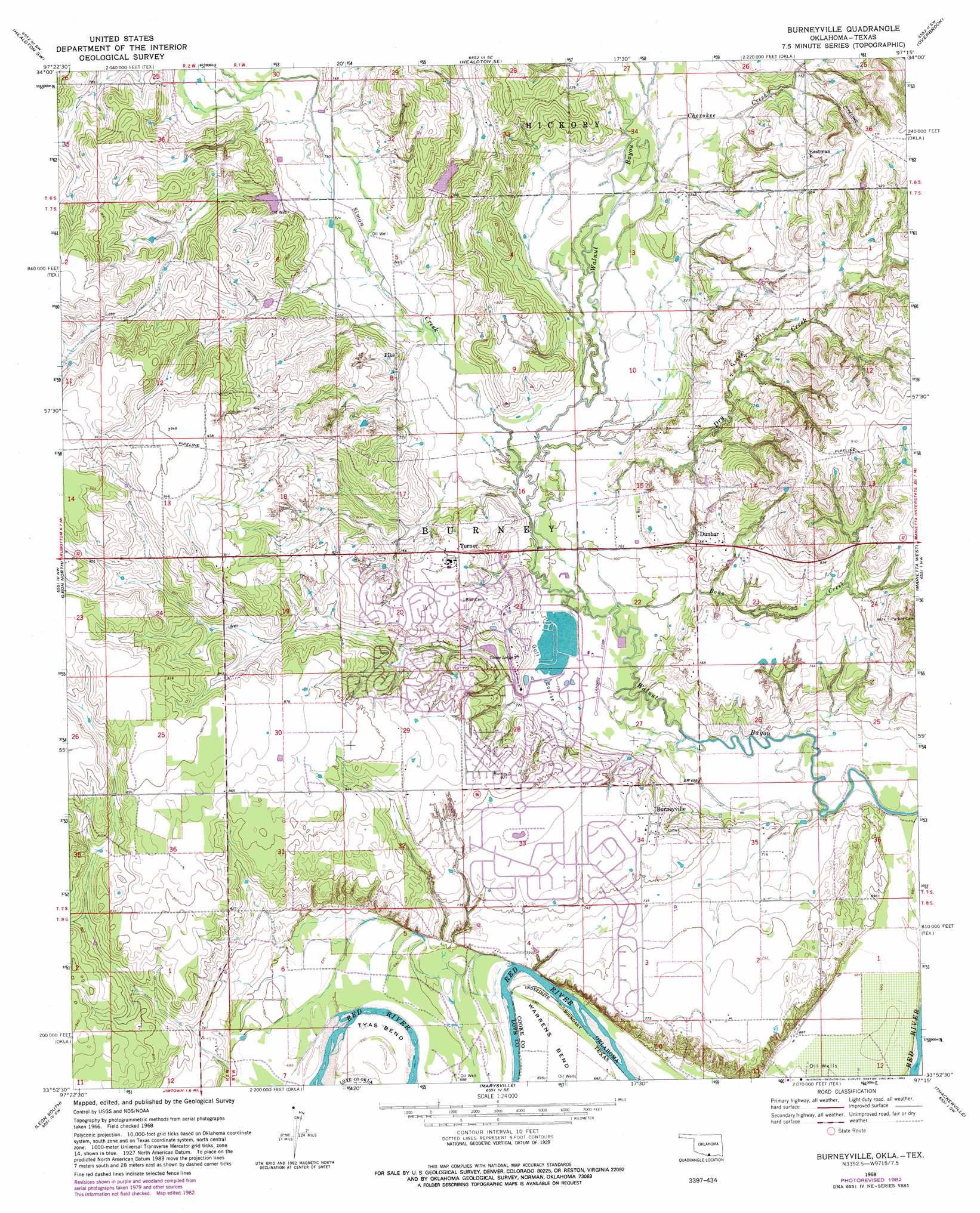
USGS Topo Quad 33097h3 - 1:24,000 scale
| Topo Map Name: | Burneyville |
| USGS Topo Quad ID: | 33097h3 |
| Print Size: | ca. 21 1/4" wide x 27" high |
| Southeast Coordinates: | 33.875° N latitude / 97.25° W longitude |
| Map Center Coordinates: | 33.9375° N latitude / 97.3125° W longitude |
| U.S. States: | OK, TX |
| Filename: | o33097h3.jpg |
| Download Map JPG Image: | Burneyville topo map 1:24,000 scale |
| Map Type: | Topographic |
| Topo Series: | 7.5´ |
| Map Scale: | 1:24,000 |
| Source of Map Images: | United States Geological Survey (USGS) |
| Alternate Map Versions: |
Burneyville OK 1968, updated 1971 Download PDF Buy paper map Burneyville OK 1968, updated 1982 Download PDF Buy paper map Burneyville OK 2010 Download PDF Buy paper map Burneyville OK 2013 Download PDF Buy paper map Burneyville OK 2016 Download PDF Buy paper map |
1:24,000 Topo Quads surrounding Burneyville
Ringling |
Healdton |
Lone Grove |
Ardmore West |
Ardmore East |
Orr |
Healdton Sw |
Healdton Se |
Overbrook |
Lake Murray |
Spanish Fort |
Leon North |
Burneyville |
Marietta West |
Marietta East |
Bonita |
Leon South |
Marysville |
Thackerville |
Horseshoe Bend |
Saint Jo |
Muenster West |
Muenster East |
Gainesville North |
Callisburg |
> Back to 33097e1 at 1:100,000 scale
> Back to 33096a1 at 1:250,000 scale
> Back to U.S. Topo Maps home
Burneyville topo map: Gazetteer
Burneyville: Bends
Tyas Bend elevation 209m 685′Burneyville: Dams
Lower Bayou Creek Site 17 Dam elevation 230m 754′Lower Bayou Creek Site 18 Dam elevation 237m 777′
Oknoname 085006 Dam elevation 210m 688′
Burneyville: Populated Places
Burneyville elevation 234m 767′Dunbar elevation 231m 757′
Eastman elevation 259m 849′
Pike elevation 230m 754′
Turner elevation 242m 793′
Burneyville: Ranges
Eastman Hills elevation 288m 944′Burneyville: Reservoirs
Lower Bayou Creek Site 17 Reservoir elevation 230m 754′Lower Bayou Creek Site 18 Reservoir elevation 237m 777′
Oknoname 085006 Reservoir elevation 210m 688′
Burneyville: Streams
Bone Creek elevation 210m 688′Cherokee Creek elevation 216m 708′
Dry Creek elevation 210m 688′
Simon Creek elevation 213m 698′
Burneyville digital topo map on disk
Buy this Burneyville topo map showing relief, roads, GPS coordinates and other geographical features, as a high-resolution digital map file on DVD: