Ross Mountain Topo Map Texas
To zoom in, hover over the map of Ross Mountain
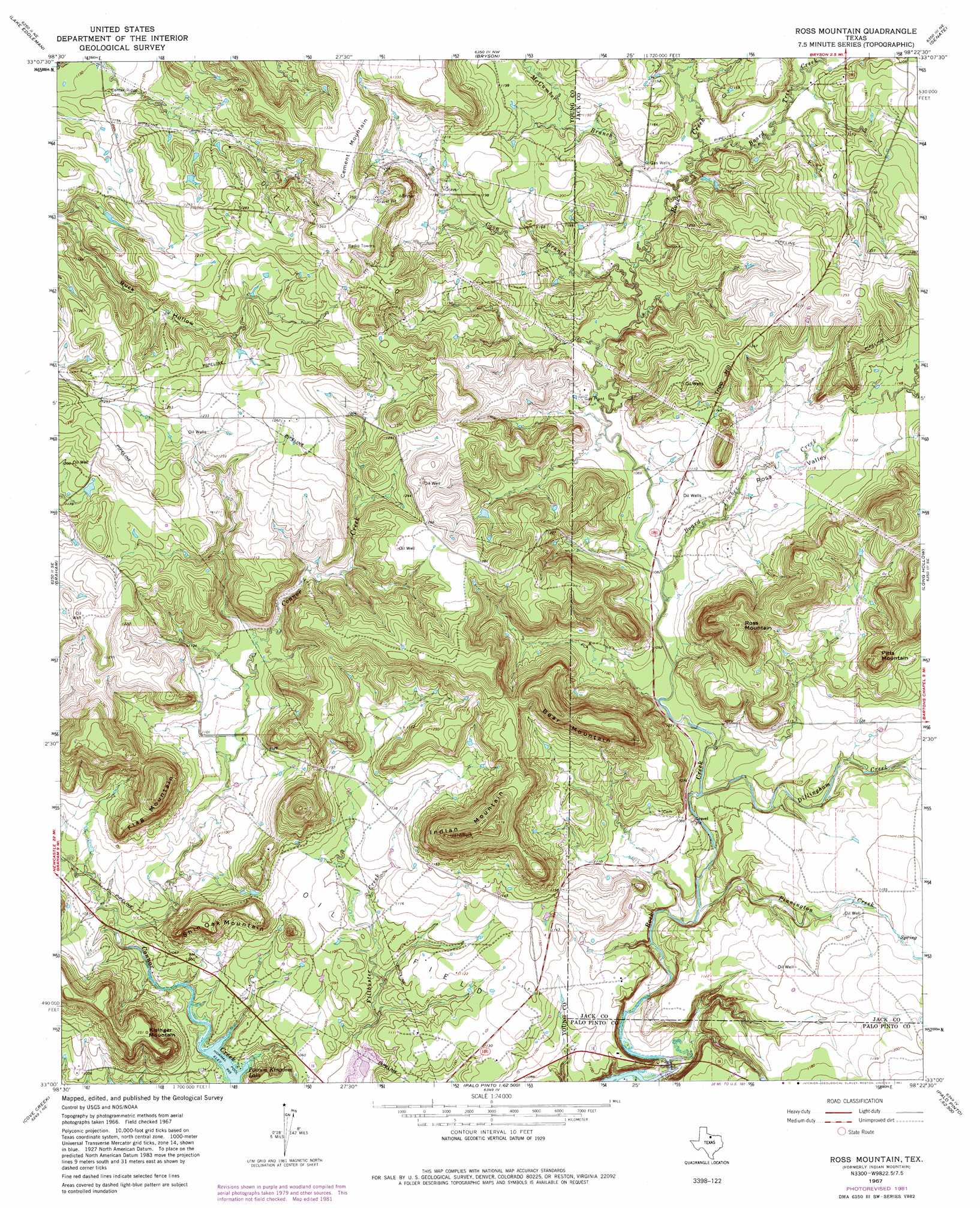
USGS Topo Quad 33098a4 - 1:24,000 scale
| Topo Map Name: | Ross Mountain |
| USGS Topo Quad ID: | 33098a4 |
| Print Size: | ca. 21 1/4" wide x 27" high |
| Southeast Coordinates: | 33° N latitude / 98.375° W longitude |
| Map Center Coordinates: | 33.0625° N latitude / 98.4375° W longitude |
| U.S. State: | TX |
| Filename: | o33098a4.jpg |
| Download Map JPG Image: | Ross Mountain topo map 1:24,000 scale |
| Map Type: | Topographic |
| Topo Series: | 7.5´ |
| Map Scale: | 1:24,000 |
| Source of Map Images: | United States Geological Survey (USGS) |
| Alternate Map Versions: |
Ross Mountain TX 1967, updated 1982 Download PDF Buy paper map Ross Mountain TX 2010 Download PDF Buy paper map Ross Mountain TX 2012 Download PDF Buy paper map Ross Mountain TX 2016 Download PDF Buy paper map |
1:24,000 Topo Quads surrounding Ross Mountain
True |
Loving |
Markley |
Lynn Creek |
Johnson Lake |
Newcastle |
Lake Eddleman |
Bryson |
Senate |
Jacksboro |
South Bend |
Graham |
Ross Mountain |
Long Hollow |
Bartons Chapel |
Ivan North |
Cove Creek |
Costello Island |
Graford West |
Graford East |
Ivan South |
Brad |
Fortune Bend |
Palo Pinto |
Mineral Wells West |
> Back to 33098a1 at 1:100,000 scale
> Back to 33098a1 at 1:250,000 scale
> Back to U.S. Topo Maps home
Ross Mountain topo map: Gazetteer
Ross Mountain: Streams
Board Timber Creek elevation 328m 1076′Board Tree Creek elevation 339m 1112′
Boaro Timber Creek elevation 352m 1154′
Coon Branch elevation 332m 1089′
Dillingham Creek elevation 319m 1046′
McCumber Branch elevation 336m 1102′
Pinnington Creek elevation 314m 1030′
Ross Mountain: Summits
Bear Mountain elevation 438m 1437′Cement Mountain elevation 410m 1345′
Flag Mountain elevation 417m 1368′
Indian Mountain elevation 434m 1423′
Kisinger Mountain elevation 379m 1243′
Pitts Mountain elevation 420m 1377′
Ross Mountain elevation 431m 1414′
Shin Oak Mountain elevation 380m 1246′
Tripp Hill elevation 381m 1250′
Ross Mountain: Valleys
Ross Valley elevation 335m 1099′Ross Mountain digital topo map on disk
Buy this Ross Mountain topo map showing relief, roads, GPS coordinates and other geographical features, as a high-resolution digital map file on DVD: